Pa Tio District
| Pa Tio ป่าติ้ว | |
|---|---|
| Amphoe | |
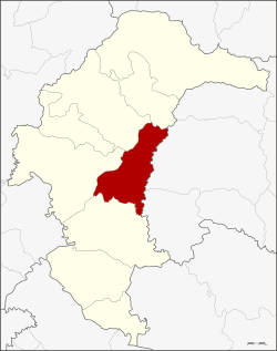 Amphoe location in Yasothon Province | |
| Coordinates: 15°49′53″N 104°23′8″E / 15.83139°N 104.38556°ECoordinates: 15°49′53″N 104°23′8″E / 15.83139°N 104.38556°E | |
| Country | Thailand |
| Province | Yasothon |
| Seat | Pho Sai |
| Area | |
| • Total | 308 km2 (119 sq mi) |
| Population (2005) | |
| • Total | 35,398 |
| • Density | 114.9/km2 (298/sq mi) |
| Time zone | UTC+7 (ICT) |
| Postal code | 35150 |
| Geocode | 3505 |
Pa Tio (Thai: ป่าติ้ว, pronounced [pàː tîw]) is a district of Yasothon Province in northeastern Thailand.
History
Around 1889 there was an influx of Lao settlers into the Isan region after a large area of Thailand east of the Mekong River was ceded to the French. Among the villages established in this migration was Ban Pa Tio.
In 1933 the Highway Department built a road from Yasothon to Amnat Charoen District and Khemarat District, which were then all districts of Ubon Ratchathani Province. The road passed through Pa Tio village, and led to its growth and expansion. In 1951, a petition was made for Pa Tio to be given minor district (king amphoe) status with jurisdiction over three (tambons): Pho Sai, Krachai, and Khok Na Ko, but it was not until 17 August 1966 that it was officially made so. It became effective on 1 September 1966.[1]
In 1969 Pa Tio was raised to district (amphoe) status, in Ubon Ratchathani Province.[2] When Yasothon became a separate province on 1 March 1972, Pa Tio was one of six districts reassigned to the new province.
Geography
Neighboring districts are (from the west clockwise) Mueang Yasothon, Kut Chum, Thai Charoen of Yasothon Province, Mueang Amnat Charoen and Hua Taphan of Amnat Charoen Province, and Kham Khuean Kaeo of Yasothon Province.
Administration
The district is divided into five sub-districts (tambon), which make up 57 villages (muban).
|
Education
The secondary schools in Pa Tio are:
References
- ↑ ประกาศกระทรวงมหาดไทย เรื่อง แบ่งท้องที่ตั้งเป็นกิ่งอำเภอ (PDF). Royal Gazette (in Thai). 83 (74 ง special): 6. September 1, 1966.
- ↑ พระราชกฤษฎีกาจัดตั้งอำเภอสมเด็จ อำเภอสีชมพู อำเภอหนองบัวแดง อำเภอบ้านแท่น อำเภอดอนตูม อำเภอนากลาง อำเภอศรีบุญเรือง และอำเภอป่าติ้ว พ.ศ. ๒๕๑๒ (PDF). Royal Gazette (in Thai). 86 (16 ก): 225–229. February 25, 1969.
External links
- District website
- amphoe.com