Yankton County, South Dakota
| Yankton County, South Dakota | |
|---|---|
_from_E_1.JPG) Scottish Rite Masonic Center in Yankton. | |
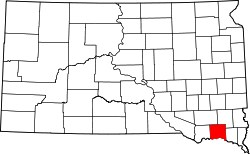 Location in the U.S. state of South Dakota | |
 South Dakota's location in the U.S. | |
| Founded | April 10, 1862 |
| Named for | Yankton Sioux |
| Seat | Yankton |
| Largest city | Yankton |
| Area | |
| • Total | 532 sq mi (1,378 km2) |
| • Land | 521 sq mi (1,349 km2) |
| • Water | 11 sq mi (28 km2), 2.1% |
| Population (est.) | |
| • (2016) | 22,616 |
| • Density | 43/sq mi (17/km2) |
| Congressional district | At-large |
| Time zone | Central: UTC−6/−5 |
| Website |
www |

Yankton County is a county located in the U.S. state of South Dakota. As of the 2010 census, the population was 22,438.[1] Its county seat is Yankton.[2]
Yankton County comprises the Yankton, SD Micropolitan Statistical Area.
Geography

According to the U.S. Census Bureau, the county has a total area of 532 square miles (1,380 km2), of which 521 square miles (1,350 km2) is land and 11 square miles (28 km2) (2.1%) is water.[3] It is bordered by the Missouri River.
Major highways
Adjacent counties
- Turner County, South Dakota - northeast
- Clay County, South Dakota - east
- Cedar County, Nebraska - southeast
- Knox County, Nebraska - southwest
- Bon Homme County, South Dakota - west
- Hutchinson County, South Dakota - northwest
Recreation and Tourism
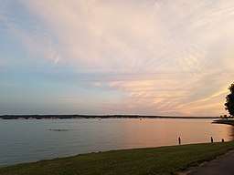
Lewis and Clark Lake is located in the southwest part of the county, approximately 4 miles west of Yankton. The Lewis and Clark Lake area is a popular regional tourist and recreation destination with numerous parks, trails, campgrounds, boat ramps, and marinas. Gavins Point Dam, which creates Lewis and Clark Lake is a popular fishing destination on the Missouri River.[4] The South Dakota Department of Game, Fish, and Parks operates the Lewis and Clark State Recreation Area on northern shore of the lake. Below Gavins Point Dam, the Missouri National Recreational River is home to one of the few non-channelized portions of the "Big Muddy", and is popular with birdwatchers, hunters, along with canoe and kayaking enthusiasts.[5]
National protected area
Demographics
| Historical population | |||
|---|---|---|---|
| Census | Pop. | %± | |
| 1870 | 2,097 | — | |
| 1880 | 8,390 | 300.1% | |
| 1890 | 10,414 | 24.1% | |
| 1900 | 12,649 | 21.5% | |
| 1910 | 13,135 | 3.8% | |
| 1920 | 15,233 | 16.0% | |
| 1930 | 16,589 | 8.9% | |
| 1940 | 16,725 | 0.8% | |
| 1950 | 16,804 | 0.5% | |
| 1960 | 17,551 | 4.4% | |
| 1970 | 19,039 | 8.5% | |
| 1980 | 18,952 | −0.5% | |
| 1990 | 19,252 | 1.6% | |
| 2000 | 21,652 | 12.5% | |
| 2010 | 22,438 | 3.6% | |
| Est. 2017 | 22,662 | [6] | 1.0% |
| U.S. Decennial Census[7] 1790-1960[8] 1900-1990[9] 1990-2000[10] 2010-2016[1] | |||
2000 census
As of the census[11] of 2000, there were 21,652 people, 8,187 households, and 5,403 families residing in the county. The population density was 42 people per square mile (16/km²). There were 8,840 housing units at an average density of 17 per square mile (7/km²). The racial makeup of the county is 95.10% White, 1.16% African American, 1.63% Native American, 0.42% Asian, 0.02% Pacific Islander, 0.74% from other races, and 0.91% from two or more races. 1.82% of the population are Hispanic or Latino of any race.
There were 8,187 households out of which 33.00% had children under the age of 18 living with them, 54.40% were married couples living together, 8.30% had a female householder with no husband present, and 34.00% were non-families. 29.30% of all households were made up of individuals and 12.00% had someone living alone who was 65 years of age or older. The average household size was 2.43 and the average family size was 3.03.
In the county, the population was spread out with 25.70% under the age of 18, 8.70% from 18 to 24, 29.00% from 25 to 44, 22.00% from 45 to 64, and 14.60% who were 65 years of age or older. The median age was 37 years. For every 100 females there were 101.90 males. For every 100 females age 18 and over, there were 101.30 males.
The median income for a household in the county was $35,374, and the median income for a family was $43,600. Males had a median income of $29,010 versus $20,686 for females. The per capita income for the county was $17,312. About 6.60% of families and 9.60% of the population were below the poverty line, including 10.00% of those under age 18 and 9.00% of those age 65 or over.
2010 census
As of the 2010 United States Census, there were 22,438 people, 8,770 households, and 5,476 families residing in the county.[12] The population density was 43.1 inhabitants per square mile (16.6/km2). There were 9,652 housing units at an average density of 18.5 per square mile (7.1/km2).[13] The racial makeup of the county was 92.8% white, 2.5% American Indian, 1.5% black or African American, 0.5% Asian, 1.1% from other races, and 1.4% from two or more races. Those of Hispanic or Latino origin made up 2.7% of the population.[12] In terms of ancestry,[14]
Of the 8,770 households, 29.2% had children under the age of 18 living with them, 50.1% were married couples living together, 8.8% had a female householder with no husband present, 37.6% were non-families, and 32.0% of all households were made up of individuals. The average household size was 2.30 and the average family size was 2.90. The median age was 41.3 years.[12]
The median income for a household in the county was $47,124 and the median income for a family was $62,070. Males had a median income of $37,637 versus $29,488 for females. The per capita income for the county was $24,776. About 5.0% of families and 11.2% of the population were below the poverty line, including 10.7% of those under age 18 and 13.5% of those age 65 or over.[15]
Government
The County is Governed by the Yankton County Commission, with five commissioners being elected by county residents.[16] The Yankton County Sheriff's Office provides law enforcement services for the county. On the state level Yankton County is located in South Dakota Legislative District 18. Yankton County is represented by Republican State Representatives Mike Stevens and Jean Hunhoff in the South Dakota House of Representatives and Democratic Senator Craig Kennedy in the South Dakota Senate.
Communities
Cities
Towns
Townships
The county is divided into nine townships:
- Gayville
- Jamesville
- Marindahl
- Mayfield
- Mission Hill
- Turkey Valley
- Utica
- Volin
- Walshtown
Unorganized territories
The county contains two areas of unorganized territory: Southeast Yankton and West Yankton.
Politics
| Year | Republican | Democratic | Third parties |
|---|---|---|---|
| 2016 | 58.8% 5,659 | 34.3% 3,301 | 6.9% 663 |
| 2012 | 55.1% 5,495 | 42.4% 4,226 | 2.5% 253 |
| 2008 | 49.7% 5,039 | 47.7% 4,838 | 2.5% 257 |
| 2004 | 57.6% 6,003 | 40.6% 4,237 | 1.8% 191 |
| 2000 | 56.1% 4,904 | 41.1% 3,596 | 2.8% 240 |
| 1996 | 44.0% 3,885 | 42.8% 3,775 | 13.2% 1,166 |
| 1992 | 36.6% 3,430 | 36.3% 3,404 | 27.1% 2,538 |
| 1988 | 52.1% 4,186 | 47.0% 3,777 | 1.0% 80 |
| 1984 | 63.4% 5,161 | 36.0% 2,932 | 0.6% 52 |
| 1980 | 61.2% 5,355 | 30.8% 2,698 | 7.9% 694 |
| 1976 | 49.8% 4,029 | 49.3% 3,987 | 0.9% 71 |
| 1972 | 53.1% 4,366 | 46.6% 3,835 | 0.3% 24 |
| 1968 | 56.1% 3,977 | 38.5% 2,733 | 5.4% 382 |
| 1964 | 46.1% 3,208 | 53.9% 3,747 | |
| 1960 | 57.0% 4,065 | 43.0% 3,061 | |
| 1956 | 57.6% 4,063 | 42.4% 2,987 | |
| 1952 | 68.4% 4,802 | 31.6% 2,220 | |
| 1948 | 49.3% 2,904 | 49.8% 2,932 | 1.0% 57 |
| 1944 | 58.4% 3,313 | 41.6% 2,359 | |
| 1940 | 57.7% 4,179 | 42.3% 3,064 | |
| 1936 | 36.3% 2,702 | 58.5% 4,349 | 5.2% 387 |
| 1932 | 25.2% 1,693 | 73.3% 4,930 | 1.6% 107 |
| 1928 | 50.9% 2,971 | 48.7% 2,841 | 0.5% 27 |
| 1924 | 39.8% 1,504 | 18.3% 693 | 41.9% 1,584 |
| 1920 | 61.8% 2,555 | 27.8% 1,147 | 10.5% 432 |
| 1916 | 48.7% 1,429 | 49.0% 1,438 | 2.4% 70 |
| 1912 | 0.0% 0 | 44.0% 1,289 | 56.0% 1,639 |
| 1908 | 56.8% 1,644 | 38.6% 1,118 | 4.6% 132 |
| 1904 | 69.0% 1,968 | 27.6% 788 | 3.3% 95 |
| 1900 | 55.8% 1,639 | 43.1% 1,268 | 1.1% 33 |
| 1896 | 51.4% 1,423 | 48.0% 1,330 | 0.6% 16 |
| 1892 | 54.0% 1,166 | 10.6% 228 | 35.5% 766 |
See also
References
- 1 2 "State & County QuickFacts". United States Census Bureau. Retrieved November 28, 2013.
- ↑ "Find a County". National Association of Counties. Retrieved 2011-06-07.
- ↑ "2010 Census Gazetteer Files". United States Census Bureau. August 22, 2012. Retrieved March 28, 2015.
- ↑ "Omaha District > Missions > Dam and Lake Projects > Missouri River Dams > Gavins Point". www.nwo.usace.army.mil. Retrieved 2018-04-15.
- ↑ https://www.nps.gov/mnrr/index.htm
- ↑ "Population and Housing Unit Estimates". Retrieved April 16, 2018.
- ↑ "U.S. Decennial Census". United States Census Bureau. Retrieved March 28, 2015.
- ↑ "Historical Census Browser". University of Virginia Library. Retrieved March 28, 2015.
- ↑ Forstall, Richard L., ed. (March 27, 1995). "Population of Counties by Decennial Census: 1900 to 1990". United States Census Bureau. Retrieved March 28, 2015.
- ↑ "Census 2000 PHC-T-4. Ranking Tables for Counties: 1990 and 2000" (PDF). United States Census Bureau. April 2, 2001. Retrieved March 28, 2015.
- ↑ "American FactFinder". United States Census Bureau. Retrieved 2011-05-14.
- 1 2 3 "DP-1 Profile of General Population and Housing Characteristics: 2010 Demographic Profile Data". United States Census Bureau. Retrieved 2016-03-12.
- ↑ "Population, Housing Units, Area, and Density: 2010 - County". United States Census Bureau. Retrieved 2016-03-12.
- ↑ "DP02 SELECTED SOCIAL CHARACTERISTICS IN THE UNITED STATES – 2006-2010 American Community Survey 5-Year Estimates". United States Census Bureau. Retrieved 2016-03-12.
- ↑ "DP03 SELECTED ECONOMIC CHARACTERISTICS – 2006-2010 American Community Survey 5-Year Estimates". United States Census Bureau. Retrieved 2016-03-12.
- ↑ "Commission - Yankton County". www.co.yankton.sd.us. Retrieved 2018-09-16.
- ↑ Leip, David. "Dave Leip's Atlas of U.S. Presidential Elections". uselectionatlas.org. Retrieved 2018-04-15.
External links
| Wikimedia Commons has media related to Yankton County, South Dakota. |
Places adjacent to Yankton County, South Dakota | ||||||||||
|---|---|---|---|---|---|---|---|---|---|---|
| ||||||||||
Municipalities and communities of Yankton County, South Dakota, United States | ||
|---|---|---|
| Cities | | |
| Towns | ||
| Footnotes | ‡This populated place also has portions in an adjacent county or counties | |
