Lemmon, South Dakota
| Lemmon, South Dakota | |
|---|---|
| City | |
 A monument of Ed Lemmon resides in Boss Cowman Square. | |
 Location in Perkins County and the state of South Dakota | |
| Coordinates: 45°56′22″N 102°9′36″W / 45.93944°N 102.16000°WCoordinates: 45°56′22″N 102°9′36″W / 45.93944°N 102.16000°W | |
| Country | United States |
| State | South Dakota |
| County | Perkins |
| Incorporated | 1908[1] |
| Area[2] | |
| • Total | 1.04 sq mi (2.69 km2) |
| • Land | 1.04 sq mi (2.69 km2) |
| • Water | 0 sq mi (0 km2) |
| Elevation | 2,569 ft (783 m) |
| Population (2010)[3] | |
| • Total | 1,227 |
| • Estimate (2015)[4] | 1,232 |
| • Density | 1,179.8/sq mi (455.5/km2) |
| Time zone | UTC−7 (Mountain (MST)) |
| • Summer (DST) | UTC−6 (MDT) |
| ZIP code | 57638 |
| Area code(s) | 605 |
| FIPS code | 46-36340 |
| GNIS feature ID | 1256086[5] |
| Website | lemmonsd.com |
Lemmon is a city in Perkins County, South Dakota, United States. The population was 1,227 at the 2010 census.
Lemmon is named after George Ed Lemmon, a cattleman, who founded the town in 1906.[6]
Geography
Lemmon is located at 45°56′22″N 102°9′36″W / 45.93944°N 102.16000°W (45.939375, -102.160128).[7] According to the United States Census Bureau, the city has a total area of 1.04 square miles (2.69 km2), all of it land.[2]
Lemmon's north border is the Adams County, North Dakota, state line. To the east of Lemmon is Corson County and Standing Rock Oyate.
History
Lemmon's history as a town started in 1902 with the U.S. government's forced leasing of approximately 800,000 acres of Standing Rock Indian Reservation lands to cattle rancher George Ed Lemmon.[8]
Demographics
| Historical population | |||
|---|---|---|---|
| Census | Pop. | %± | |
| 1910 | 1,255 | — | |
| 1920 | 1,126 | −10.3% | |
| 1930 | 1,508 | 33.9% | |
| 1940 | 1,781 | 18.1% | |
| 1950 | 2,760 | 55.0% | |
| 1960 | 2,412 | −12.6% | |
| 1970 | 1,997 | −17.2% | |
| 1980 | 1,871 | −6.3% | |
| 1990 | 1,614 | −13.7% | |
| 2000 | 1,398 | −13.4% | |
| 2010 | 1,227 | −12.2% | |
| Est. 2016 | 1,216 | [9] | −0.9% |
| U.S. Decennial Census[10] 2015 Estimate[4] | |||
2010 census
As of the census[3] of 2010, there were 1,227 people, 567 households, and 319 families residing in the city. The population density was 1,179.8 inhabitants per square mile (455.5/km2). There were 732 housing units at an average density of 703.8 per square mile (271.7/km2). The racial makeup of the city was 96.3% White, 0.1% African American, 1.9% Native American, 0.2% Asian, 0.1% from other races, and 1.5% from two or more races. Hispanic or Latino of any race were 0.7% of the population.
There were 567 households of which 20.8% had children under the age of 18 living with them, 46.7% were married couples living together, 6.9% had a female householder with no husband present, 2.6% had a male householder with no wife present, and 43.7% were non-families. 39.5% of all households were made up of individuals and 20.7% had someone living alone who was 65 years of age or older. The average household size was 2.05 and the average family size was 2.73.
The median age in the city was 50.8 years. 17.4% of residents were under the age of 18; 5.4% were between the ages of 18 and 24; 18.3% were from 25 to 44; 31.2% were from 45 to 64; and 27.6% were 65 years of age or older. The gender makeup of the city was 47.6% male and 52.4% female.
2000 census
As of the census of 2000, there were 1,398 people, 623 households, and 356 families residing in the city. The population density was 1,378.7 people per square mile (534.4/km²). There were 776 housing units at an average density of 765.3 per square mile (296.6/km²). The racial makeup of the city was 95.99% White, 0.14% African American, 2.65% Native American, 0.36% Asian, 0.29% from other races, and 0.57% from two or more races. Hispanic or Latino of any race were 0.50% of the population.
There were 623 households out of which 25.2% had children under the age of 18 living with them, 47.5% were married couples living together, 7.9% had a female householder with no husband present, and 42.7% were non-families. 40.3% of all households were made up of individuals and 22.2% had someone living alone who was 65 years of age or older. The average household size was 2.15 and the average family size was 2.91.
In the city, the population was spread out with 22.9% under the age of 18, 6.3% from 18 to 24, 24.7% from 25 to 44, 18.7% from 45 to 64, and 27.5% who were 65 years of age or older. The median age was 42 years. For every 100 females, there were 84.2 males. For every 100 females age 18 and over, there were 81.2 males.
As of 2000 the median income for a household in the city was $28,109, and the median income for a family was $37,813. Males had a median income of $27,426 versus $17,813 for females. The per capita income for the city was $17,272. About 8.0% of families and 12.0% of the population were below the poverty line, including 12.1% of those under age 18 and 16.0% of those age 65 or over.
Climate
| Climate data for Lemmon, South Dakota | |||||||||||||
|---|---|---|---|---|---|---|---|---|---|---|---|---|---|
| Month | Jan | Feb | Mar | Apr | May | Jun | Jul | Aug | Sep | Oct | Nov | Dec | Year |
| Record high °F (°C) | 69 (21) |
70 (21) |
81 (27) |
93 (34) |
96 (36) |
109 (43) |
109 (43) |
105 (41) |
105 (41) |
95 (35) |
82 (28) |
67 (19) |
109 (43) |
| Average high °F (°C) | 29 (−2) |
33 (1) |
44 (7) |
58 (14) |
69 (21) |
78 (26) |
86 (30) |
85 (29) |
75 (24) |
60 (16) |
42 (6) |
30 (−1) |
57 (14) |
| Average low °F (°C) | 9 (−13) |
13 (−11) |
21 (−6) |
32 (0) |
43 (6) |
52 (11) |
58 (14) |
57 (14) |
46 (8) |
35 (2) |
22 (−6) |
11 (−12) |
33 (1) |
| Record low °F (°C) | −33 (−36) |
−33 (−36) |
−27 (−33) |
−4 (−20) |
10 (−12) |
32 (0) |
40 (4) |
33 (1) |
18 (−8) |
−4 (−20) |
−18 (−28) |
−33 (−36) |
−33 (−36) |
| Average precipitation inches (mm) | 0.35 (8.9) |
0.51 (13) |
1.01 (25.7) |
1.62 (41.1) |
2.85 (72.4) |
2.89 (73.4) |
2.80 (71.1) |
1.99 (50.5) |
1.41 (35.8) |
1.33 (33.8) |
0.70 (17.8) |
0.42 (10.7) |
17.88 (454.2) |
| Source: The Weather Channel (Historical Monthly Averages) [11] | |||||||||||||
Arts and culture
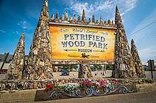
The city contains the Lemmon Petrified Park, the home of the worlds largest petrified wood park. This tourist attraction fills an entire block of the downtown area and is built entirely of petrified wood, fossils and stone. Construction began in 1930 and continued until 1932 under the supervision of Ole S. Quammen. It was in private ownership until 1954 when it was donated to the city by Quammen's heirs. The park features a wishing well, a waterfall, and a castle. The castle weighs 300 tons and boasts towering spires and turrets. Also in the park are two separate museums, both built entirely of petrified wood. The larger of the two is circular has a petrified grass floor along with petrified logs. Dinosaur claws, bird tracks and fossilized snakes can be seen in the petrified wood. Also in the museum are antiques and artifacts from the Lemmon area. The formations in the park number over 100 and are up to 20 feet tall.
The Boss Cowman Rodeo and Celebration is the second weekend in July, and is one of the largest rodeos in the state.
The Grand River Museum is located on Highway 12. The Museum features exhibits on creation science, fossils, Native Americans, cowboys and ranch life, a full-scale tipi and a model of the Ark. Admission is free.
The Kokomo is located on main-street and is the home of Sculptor John Lopez's Art Gallery. Many of the Lemmon area's youth had they're first beer in the Kokomo in years back. www.johnlopezstudio.com

Lemmon has a 9-hole golf course, an airport, two convenience stores, a hardware store, a grocery store, an American Legion, and many other businesses. It is home to the Powderhorn family restaurant, the Alaska Cafe, Benny's steakhouse, the R bar, and the Chinese Garden. Lemmon also has 7 churches, 3 financial institutions, a library, a movie theater, a clinic, a nursing home, an eye clinic, a dentistry office, and a veterinarian clinic. There are also 3 hotels in town, the Dakota Lodge, the Lemmon Country Inn, and the In Town Motel. The Lemmon Sale Barn is just to the west of town, with sales every Wednesday.
Many Lemmonites are employed at Wheeler Manufacturing, which produces jewelry products. Gregorian, Inc., and Dakota Woodcrafts also employ manufacturing workers. Other major employers are the school system B &C Plumbing and Heating and ranches.
Government
The mayor of Lemmon is Neal Pinnow, who was elected in April 2008 to replace outgoing mayor Wally Dauwen. The city council has eight members. The Lemmon Police Department was absorbed by the Perkins County Sheriffs Department now having 3 deputies, along with a SD Highway Patrolman stationed in Lemmon and a 30-man volunteer fire department.
Education
Lemmon's school district includes a high school and an elementary school. The Progress country school operated in Meadow until the summer of 2010, when it was destroyed by a tornado. The small rural school district was then consolidated into the Lemmon and Faith districts.
Local media
AM radio
| AM radio stations | |||||
|---|---|---|---|---|---|
| Frequency | Call sign | Name | Format | Owner | City |
| 1400 AM | KBJM | Country/Classic Hits | Media Associates | Lemmon | |
Notable people
See also
References
- ↑ "SD Towns" (PDF). South Dakota State Historical Society. Archived from the original (PDF) on 2010-02-10. Retrieved 2010-02-14.
- 1 2 "US Gazetteer files 2010". United States Census Bureau. Archived from the original on 2012-01-24. Retrieved 2012-06-21.
- 1 2 "American FactFinder". United States Census Bureau. Retrieved 2012-06-21.
- 1 2 "Population Estimates". United States Census Bureau. Archived from the original on October 19, 2016. Retrieved June 7, 2016.
- ↑ "US Board on Geographic Names". United States Geological Survey. 2007-10-25. Retrieved 2008-01-31.
- ↑ Federal Writers' Project (1940). South Dakota place-names, v.1-3. University of South Dakota. p. 47.
- ↑ "US Gazetteer files: 2010, 2000, and 1990". United States Census Bureau. 2011-02-12. Retrieved 2011-04-23.
- ↑ Welsh, Herbert. The Action of the Interior Department in Forcing the Standing Rock Indians to Lease Their Lands to Cattle Syndicates, Philadelphia: The Indian Rights Association 1902. https://books.google.com/books?id=3OgNAAAAIAAJ
- ↑ "Population and Housing Unit Estimates". Retrieved June 9, 2017.
- ↑ United States Census Bureau. "Census of Population and Housing". Retrieved July 15, 2014.
- ↑ "Climate Statistics for Lemmon, SD". Retrieved January 30, 2012.
| Wikimedia Commons has media related to Lemmon, South Dakota. |
Municipalities and communities of Perkins County, South Dakota, United States | ||
|---|---|---|
| City | 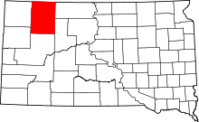 | |
| Town | ||
| Townships |
| |
| CDP | ||
| Other unincorporated communities | ||
| Ghost towns | ||
| Indian reservation | ||
| Footnotes | ‡This populated place also has portions in an adjacent county or counties | |
