Dell Rapids, South Dakota
| Dell Rapids | |
|---|---|
| City | |
| Dell Rapids, South Dakota | |
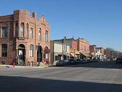 Sioux Quartzite was used in the reconstruction of downtown Dell Rapids after a fire burned down the wooden buildings in the 1880’s. | |
| Nickname(s): “The Little City with the Big Attractions” | |
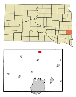 Location in Minnehaha County and the state of South Dakota | |
| Coordinates: 43°49′30″N 96°42′40″W / 43.82500°N 96.71111°WCoordinates: 43°49′30″N 96°42′40″W / 43.82500°N 96.71111°W | |
| Country | United States |
| State | South Dakota |
| County | Minnehaha |
| Founded | 1871[1] |
| Incorporated | 1888[2] |
| Area[3] | |
| • Total | 2.09 sq mi (5.41 km2) |
| • Land | 2.03 sq mi (5.26 km2) |
| • Water | 0.06 sq mi (0.16 km2) |
| Elevation | 1,509 ft (460 m) |
| Population (2010)[4] | |
| • Total | 3,633 |
| • Estimate (2017)[5] | 3,652 |
| • Density | 1,789.7/sq mi (691.0/km2) |
| Time zone | UTC−6 (Central (CST)) |
| • Summer (DST) | UTC−5 (CDT) |
| ZIP code | 57022 |
| Area code(s) | 605 |
| FIPS code | 46-15980 |
| GNIS feature ID | 1265635[6] |
| Website | City of Dell Rapids |
Dell Rapids is a city in Minnehaha County, South Dakota, United States. The population was 3,633 at the 2010 census. It is known as "The Little City with the Big Attractions."
The city took its name from the Dells of the Wisconsin River, which were likened to the local rapids on the Big Sioux River.[7]
History
Dell Rapids was originally named Dell City, but it was changed to its current name because of the rapids of the Big Sioux River.[7] A fire broke out on the main street and burned most of it, so it was rebuilt out of Sioux Quartzite,[7] a common rock found in the area. The Chicago, Milwaukee, and Saint Paul Railroad built a railroad into the area, reaching Dell Rapids from Egan in 1881. Two large Sioux Quartzite quarries owned by LG. Everest are operated via this rail line, which is now operated by LG’s subsidiary, the D&I Railroad. The community celebrates its heritage with the annual “Quarry Days”, which takes place in July, and in June, the city hosts “Cootie Days”, where rides and games are set up and available in the city’s park.
Geography
Dell Rapids is located at 43°49′30″N 96°42′40″W / 43.82500°N 96.71111°W (43.824883, -96.711158),[8] along the Big Sioux River.[9]
According to the United States Census Bureau, the city has a total area of 2.09 square miles (5.41 km2), of which, 2.03 square miles (5.26 km2) is land and 0.06 square miles (0.16 km2) is water.[3]
Dell Rapids has been assigned the ZIP code 57022 and the FIPS place code 15980.
Demographics
| Historical population | |||
|---|---|---|---|
| Census | Pop. | %± | |
| 1880 | 260 | — | |
| 1890 | 993 | 281.9% | |
| 1900 | 1,255 | 26.4% | |
| 1910 | 1,367 | 8.9% | |
| 1920 | 1,677 | 22.7% | |
| 1930 | 1,657 | −1.2% | |
| 1940 | 1,706 | 3.0% | |
| 1950 | 1,650 | −3.3% | |
| 1960 | 1,863 | 12.9% | |
| 1970 | 1,991 | 6.9% | |
| 1980 | 2,389 | 20.0% | |
| 1990 | 2,484 | 4.0% | |
| 2000 | 2,980 | 20.0% | |
| 2010 | 3,633 | 21.9% | |
| Est. 2017 | 3,652 | [10] | 0.5% |
| U.S. Decennial Census[11] 2017 Estimate[5] | |||
2010 census
As of the census[4] of 2010, there were 3,633 people, 1,388 households, and 973 families residing in the city. The population density was 1,789.7 inhabitants per square mile (691.0/km2). There were 1,495 housing units at an average density of 736.5 per square mile (284.4/km2). The racial makeup of the city was 98.0% White, 0.1% African American, 0.6% Native American, 0.2% Asian, 0.2% from other races, and 0.9% from two or more races. Hispanic or Latino of any race were 1.4% of the population.
There were 1,388 households of which 38.3% had children under the age of 18 living with them, 58.8% were married couples living together, 7.8% had a female householder with no husband present, 3.5% had a male householder with no wife present, and 29.9% were non-families. 25.1% of all households were made up of individuals and 11.4% had someone living alone who was 65 years of age or older. The average household size was 2.58 and the average family size was 3.10.
The median age in the city was 34.8 years. 28.9% of residents were under the age of 18; 6.6% were between the ages of 18 and 24; 27.6% were from 25 to 44; 21.7% were from 45 to 64; and 15% were 65 years of age or older. The gender makeup of the city was 48.7% male and 51.3% female.
2000 census
As of the census of 2000, there were 2,980 people, 1,127 households, and 793 families residing in the city. The population density was 1,519.9 people per square mile (587.0/km²). There were 1,181 housing units at an average density of 602.3 per square mile (232.6/km²). The racial makeup of the city was 98.69% White, 0.13% African American, 0.47% Native American, 0.20% Asian, 0.07% from other races, and 0.44% from two or more races. Hispanic or Latino of any race were 0.64% of the population.
There were 1,127 households out of which 36.7% had children under the age of 18 living with them, 60.5% were married couples living together, 7.2% had a female householder with no husband present, and 29.6% were non-families. 26.0% of all households were made up of individuals and 13.5% had someone living alone who was 65 years of age or older. The average household size was 2.55 and the average family size was 3.09.
In the city, the population was spread out with 28.4% under the age of 18, 6.5% from 18 to 24, 27.3% from 25 to 44, 19.4% from 45 to 64, and 18.3% who were 65 years of age or older. The median age was 36 years. For every 100 females, there were 91.4 males. For every 100 females age 18 and over, there were 90.3 males.
As of 2000 the median income for a household in the city was $42,572, and the median income for a family was $49,536. Males had a median income of $31,867 versus $24,333 for females. The per capita income for the city was $17,731. About 1.9% of families and 4.0% of the population were below the poverty line, including 2.3% of those under age 18 and 12.7% of those age 65 or over.
Education
Dell Rapids is home to two separate school systems: The Dell Rapids public school system and St. Mary’s, a private Catholic parishoal school.
The public school system includes Dell Rapids High School, a middle school, and an elementary school. The mascot of the Public School District is the "Quarriers", named after the large Sioux Quartzite rock quarries that are also in Dell Rapids. St. Mary's school also includes St. Mary High School, a junior high school, and elementary school. The mascot of the St. Mary School District is the "Cardinals".
Notable people
- Daniel Ahlers, member of the South Dakota House of Representatives
- Dennis Daugaard, Current Governor of South Dakota
- William E. Merry, member of the South Dakota House of Representatives
- John Mortvedt, soil scientist born and raised on a farm near Dell Rapids
References
- ↑ Thompson (ed.), p. 167.
- ↑ "SD Towns" (PDF). South Dakota State Historical Society. Archived from the original (PDF) on February 10, 2010. Retrieved February 11, 2010.
- 1 2 "US Gazetteer files 2010". United States Census Bureau. Archived from the original on 2012-01-24. Retrieved 2012-06-21.
- 1 2 "American FactFinder". United States Census Bureau. Retrieved 2012-06-21.
- 1 2 "Population Estimates". United States Census Bureau. Retrieved October 5, 2018.
- ↑ "US Board on Geographic Names". United States Geological Survey. 2007-10-25. Retrieved 2008-01-31.
- 1 2 3 Federal Writers' Project (1940). South Dakota place-names, v.1-3. University of South Dakota. p. 34.
- ↑ "US Gazetteer files: 2010, 2000, and 1990". United States Census Bureau. 2011-02-12. Retrieved 2011-04-23.
- ↑ DeLorme (2001). South Dakota Atlas & Gazetteer. Yarmouth, Maine: DeLorme. ISBN 0-89933-330-3
- ↑ "Population and Housing Unit Estimates". Retrieved June 9, 2017.
- ↑ United States Census Bureau. "Census of Population and Housing". Retrieved September 23, 2013.
Bibliography
- Thompson, Harry F. (ed.) (2009). A New South Dakota History (Second ed.). Sioux Falls, SD: Center for Western Studies - Augustana College. ISBN 978-0-931170-00-3.
External links
| Wikimedia Commons has media related to Dell Rapids, South Dakota. |
Places adjacent to Dell Rapids, South Dakota | ||||||||||
|---|---|---|---|---|---|---|---|---|---|---|
| ||||||||||
Municipalities and communities of Minnehaha County, South Dakota, United States | ||
|---|---|---|
| Cities | 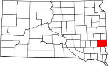 | |
| Towns | ||
| CDPs | ||
| Other unincorporated communities | ||
| Townships | ||
| Footnotes | ‡This populated place also has portions in an adjacent county or counties | |
