Lewis and Clark Lake
| Lewis and Clark Lake | |
|---|---|
 | |
| Location |
|
| Coordinates | 42°51′45″N 97°29′30″W / 42.8625°N 97.4917°WCoordinates: 42°51′45″N 97°29′30″W / 42.8625°N 97.4917°W |
| Type | reservoir (artificial lake; man-made lake) |
| Primary inflows | Missouri River, Niobrara River |
| Primary outflows | Missouri River |
| Catchment area | 16,000 sq mi (41,000 km2) |
| Basin countries | United States |
| Max. length | 25 miles (40 km) |
| Max. width | 1.8 miles (2.9 km) at dam |
| Surface area | 31,400 acres (12,700 ha) |
| Average depth | 15–30 ft (4.6–9.1 m) |
| Max. depth | 45 ft (14 m) |
| Water volume | 492,000 acre⋅ft (0.607 km3)[1] |
| Shore length1 | 90 mi (140 km) |
| Surface elevation | 1,206–1,210 ft (368–369 m) msl |
| Settlements | Yankton, Springfield, Running Water, Santee, and Niobrara. |
| 1 Shore length is not a well-defined measure. | |

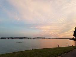
Lewis and Clark Lake is a 31,400 acre (130 km²) artificial lake located on the border of the U.S. States of Nebraska and South Dakota on the Missouri River. The lake is approximately 25 miles (40 km) in length with over 90 miles (140 km) of shoreline and a maximum water depth of 45 feet (14 m).[2] The lake is impounded by Gavins Point Dam and is managed by the U.S. Army Corps of Engineers. The lake is located within Cedar and Knox Counties in Nebraska and Bon Homme and Yankton Counties in South Dakota. The lake is located approximately 4 miles (6.4 km) west or upstream of Yankton, South Dakota.
History
The Missouri River Valley Area is abound with history involving several early Native American Tribes, Pioneers, and other settlers to the area due to ease of river transportation and abundant resources.[3] Lewis and Clark Lake is named after explorers Meriwether Lewis and William Clark of the Lewis and Clark Expedition. The lake is located along the Lewis and Clark National Historic Trail.[4]
The archaeological record in the area dates back to the Archaic Period, sometime around 3,000 to 5,000 B.C. The Archaic Period people lived along small tributary streams that flow into the Missouri Valley. Later, Woodland Period people (500 B.C. – 1,000 A.D.) lived in the area. More recent inhabitants include the Ponca, Yankton Sioux and Omaha tribes in the late 18th and 19th centuries.[5] The Minnesota Santee Sioux arrived on the river shore in the mid-1800's and remain in the area. In 1804, while traveling up the Missouri River on their epic journey to the Pacific Ocean, Lewis and Clark participated in a Grand council with the Yankton Sioux at a site below Calumet Bluff. This significant meeting was the first meeting with a Sioux tribe on their journey upstream. The lake area is a part of the Lewis and Clark National Historic Trail.[6] In 1874, the Bon Homme Colony of Hutterites, a branch of the Mennonite movement exiled from Austria, settled on what is now the north shore of Lewis and Clark Lake. They are the first Hutterite Colony in South Dakota and the United States. The colony maintains a traditional communal way of life.[7] The lake was filled in 1957 with the completion of construction of Gavins Point Dam across the river valley.
Parks and recreation


Lewis and Clark Lake is a very popular regional tourist destination in the upper Midwest for camping, water sports, hiking, bird watching, hunting, fishing, swimming, and biking. Average annual public visitation exceeds one-million visitors per year to the lake area. There are several public recreation areas along the lake with numerous boat ramps, marinas, campgrounds, and day-use areas. The upper stretches of the lake are renowned for their superior waterfowl viewing and hunting opportunities along the Missouri River flyway.
The U.S. Army Corps of Engineers manages several campgrounds and parks below Gavins Point Dam. The Lewis & Clark Recreation Area, a South Dakota state park is a popular recreational destination, several boat ramps, a full-service marina and resort, and over 400 campsites are available for public use. Lewis & Clark State Recreation Area is a popular state recreation area in Nebraska along the lake's southern shore with several campgrounds, rental cabins, full-service marina and several trails. Springfield Recreation Area near the upper part of the lake is also popular with visitors for camping and lake access. There are two golf courses along the lakeshore, Crofton-Lakeview Golf Course, near Crofton and Springfield Golf Course near Springfield[8]. Located downstream of the lake is the 59-mile reach of the Missouri National Recreational River (MNRR) which stretches eastward from the dam to Ponca State Park, upstream of the lake is the 39-mile reach of the MNRR which stretches westward to Fort Randall Dam.
Lewis and Clark Visitor Center
The Lewis and Clark Visitor Center is located just south of Gavins Point Dam atop Calumet Bluff with stunning views of Lewis and Clark Lake, Lake Yankton, and the Missouri River below the dam. The visitor center is open daily from Memorial Day weekend through Labor Day weekend and open weekdays during other times of the year. The visitor center interprets the history of the Missouri River Basin, including Native Americans, pioneers, the Lewis and Clark Expedition (which traveled through the area); along with local wildlife and the history of the Corps of Engineers in the area. A theater shows educational videos on the Lewis and Clark Expedition, construction of Gavins Point Dam, and the natural history of the Missouri River Region. A bookstore offers educational books, videos, and other merchandise for sale. The visitor center is known for exceptional viewing of the majestic American Bald Eagle, which frequents the Missouri River below the dam, especially in winter months. The visitors center is operated and staffed by U.S. Army Corps of Engineers Park Rangers, who also give guided tours of Gavins Point Dam and the power plant.[9]
Fish, wildlife and natural resources
The natural resources and public lands on and around the lake are cooperatively managed by the U.S. Army Corps of Engineers, Nebraska Game and Parks Commission, and the South Dakota Department of Game, Fish, and Parks. Common game species around the lake include White-tailed deer, Wild Turkey, many species of waterfowl, Pheasant, Cottontail rabbit, Mourning Dove, and squirrel. The American Bald Eagle is commonly seen around the dam and lake area, especially in the winter months. Each January the Lewis and Clark Visitor Center hosts "Bald Eagle Days" a live-bird program that is popular with visitors.[10]
Species of fish present include walleye, northern pike, sauger, sunfish, yellow perch, common carp, black bullhead, channel catfish, and smallmouth bass.[11]. Fishing below Gavins Point Dam is very popular, especially for the annual paddlefish snagging season in October and bowfishing in June. The "Fishing Wall" immediately below the dam's spillway is popular for fishing year-round as the dam keeps the river free of ice in the winter months.
The U.S. Army Corps of Engineers and the U.S. Fish and Wildlife Service monitor and manage threatened and endangered species on the lake and river. Species of concern include the Pallid sturgeon, least tern, and piping plover. A branch of the Corps known as the Missouri River Recovery Program monitors these species and helps to restore native habitat that was lost as a result of dam construction and channelization of the Missouri River.[12] The Gavins Point National Fish Hatchery is located just downstream of the lake[13].
Current lake issues
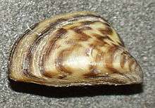
There are several issues impacting recreation, wildlife, and other issues. In 2014 zebra mussels, an aquatic invasive mussel were discovered in the lake and have infested the reservoir and the Missouri River downstream of Gavins Point Dam.[14]
Lewis and Clark Lake is significantly impacted by sedimentation and siltation issues, diminishing the overall water surface area, water storage capacity, and recreational opportunities. Sediment carried by the Missouri River and Niobrara River is slowed and trapped within the reservoir due to the dam impounding and thus slowing the natural river flow. Studies show approximately 5.1 tons of sediment are deposited in the lake each year, which contributes to the lake's increasing size of delta area on the western portions of the lake. Approximately 60% of the sediment comes from the Nebraska Sandhills via the Niobrara River. As of 2016, approximately 30% of the lake's overall surface area has diminished due to sedimentation deposits, and some figures project by 2045 approximately 50% of the lake will be diminished due to sedimentation deposits. Presently, there is no plan or solution to remove or slow the progression of the siltation within the lake.[15]
See also
Further reading
External links
- U.S. Army Corps of Engineers, Gavins Point Project (Lewis and Clark Lake)
- Recreation.gov - Lewis and Clark Lake Public Recreation
- Missouri River Basin Daily River Conditions Bulletin - U.S. Army Corps of Engineers
- South Dakota Department of Game, Fish and Parks
- Nebraska Game and Parks Commission
- Title 36 Code of Federal Regulations (CFR) - Rules and Regulations governing public use of U.S. Army Corps of Engineers Water Resource Development Projects
- Missouri River Recovery Program
References
- ↑ "Gavins Point Dam & Power Plant". United States Army Corps of Engineers. Archived from the original on 2011-06-01. Retrieved 2010-04-26.
- ↑ http://www.nwo.usace.army.mil/Missions/Dam-and-Lake-Projects/Missouri-River-Dams/
- ↑ http://www.nwo.usace.army.mil/Missions/Civil-Works/Cultural-Resources/
- ↑ https://www.nps.gov/lecl/index.htm
- ↑ http://www.nwo.usace.army.mil/Missions/Dam-and-Lake-Projects/Missouri-River-Dams/Gavins-Point/
- ↑ https://www.nps.gov/lecl/index.htm
- ↑ http://www.nwo.usace.army.mil/Missions/Dam-and-Lake-Projects/Missouri-River-Dams/Gavins-Point/
- ↑ http://www.nwo.usace.army.mil/
- ↑ http://www.nwo.usace.army.mil/Missions/Dam-and-Lake-Projects/Missouri-River-Dams/Gavins-Point/
- ↑ http://www.nwo.usace.army.mil/Missions/Dam-and-Lake-Projects/Missouri-River-Dams/Gavins-Point/
- ↑ https://outdoornebraska.gov/wp-content/uploads/2015/10/2015FishSamplingReport_LewisAndClarkReservoir.pdf
- ↑ http://moriverrecovery.usace.army.mil/mrrp/f?p=136:1
- ↑ https://www.fws.gov/mountain-prairie/fisheries/gavinsPoint.php
- ↑ http://www.nwo.usace.army.mil/Media/News-Releases/Article/617615/zebra-mussels-discovered-at-lewis-and-clark-lake/
- ↑ http://msaconline.com/