Gavins Point Dam
| Gavins Point Dam | |
|---|---|
 Aerial view of Gavins Point Dam power plant and spillway, on the Missouri River impounding Lewis and Clark Lake. | |
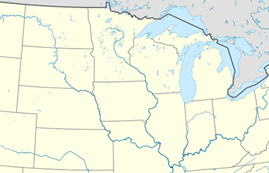 Location of Gavins Point Dam in the Midwestern United States.  Gavins Point Dam (the US) | |
| Country | United States |
| Location |
Nebraska and South Dakota near Yankton, South Dakota |
| Coordinates | 42°50′58″N 97°28′55″W / 42.849382°N 97.482018°WCoordinates: 42°50′58″N 97°28′55″W / 42.849382°N 97.482018°W |
| Status | Operational |
| Construction began | 1952 |
| Opening date | 1957 |
| Construction cost | $51 million |
| Owner(s) | U.S. Army Corps of Engineers |
| Dam and spillways | |
| Type of dam | Embankment, rolled-earth and chalk-fill |
| Impounds | Missouri River |
| Height | 74 ft (23 m) |
| Length | 8,700 ft (2,652 m) |
| Width (crest) | 35 ft (11 m) |
| Width (base) | 850 ft (259 m) |
| Dam volume | 7,000,000 cu yd (5,351,884 m3) |
| Reservoir | |
| Creates | Lewis and Clark Lake |
| Total capacity | 492,000 acre⋅ft (606,873,064 m3) |
| Catchment area | 279,480 sq mi (723,850 km2) |
| Surface area | 31,400 acres (12,700 ha) |
| Maximum length | 25 mi (40 km) |
| Maximum water depth | 45 ft (14 m) |
| Normal elevation | 1,210 feet msl |
| Power Station | |
| Operator(s) | U.S. Army Corps of Engineers |
| Commission date | 1957 |
| Turbines | 3 x 44 MW |
| Installed capacity | 132 MW |
| Annual generation | 727 million KWh[1] |
|
Website U.S. Army Corps of Engineers, Gavins Point Project | |
Gavins Point Dam is a large embankment rolled-earth and chalk-fill dam on the Missouri River, located in the U.S. States of Nebraska and South Dakota in the Upper Midwest Region of the United States. The dam was constructed from 1952 to 1957 by the United States Army Corps of Engineers. The dam creates the 31,400 acre (12,700 ha) Lewis and Clark Lake. The dam is located approximately 4 miles west of Yankton, South Dakota in both Cedar County, Nebraska and Yankton County, South Dakota.
History

Gavins Point Dam was constructed as a part of the Pick–Sloan Missouri Basin Program, authorized by the Flood Control Act of 1944 by Congress. The dam operations work in conjunction with the other Pick-Sloan Program Dams to assist with conservation, control, and use of water resources in the Missouri River Basin. The intended beneficial uses of these water resources include flood control, aids to navigation, irrigation, supplemental water supply, power generation, municipal and industrial water supplies, stream-pollution abatement, Sediment control, preservation and enhancement of fish and wildlife, and creation of recreation opportunities. Gavins Point is the most downstream dam on the Missouri River at river mile 811.1. The next dam upstream is Fort Randall Dam.
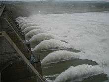
During the 2011 Missouri River Flood, the dam released a record water flow of 160,200 cfs, the previous record was 70,000 cfs in 1997. During the 2011 flood, the dam was damaged by debris and a significant portion of rocks were dislodged from its upstream side. The U.S. Army Corps of Engineers soon began repairs to the dam and its spillway gates. Pressure sensors were also installed in concrete portion of the dam.[3][4]
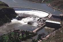
Hydroelectric Power Generation
The dam has a hydroelectric power plant with three generators, each having a nameplate capacity of 44,099 kW, for a total of 132.297 MW.[5] The hydroelectric power plant provides enough electricity to supply 68,000 homes. Power generated is sold through the Western Area Power Administration.
Reservoir
See main article: Lewis and Clark Lake
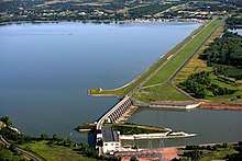
Gavins Point Dam creates Lewis and Clark Lake, a popular regional tourist destination for water-based recreational opportunities including boating and fishing, along with camping, hiking, and hunting opportunities managed by the State of South Dakota, State of Nebraska, and the U.S. Army Corps of Engineers (USACE). Public tours of the power plant are offered weekends between Memorial Day weekend and Labor Day weekend by USACE Park Rangers. The nearby Lewis and Clark Visitor Center on the Nebraska-side of the dam is open daily and tells the story of dam construction, along with local history, wildlife and the Lewis and Clark Expedition. The Gavins Point National Fish Hatchery is located just downstream of the dam on the South Dakota side.
Lewis and Clark Lake is significantly impacted by sedimentation and siltation issues, diminishing the overall water surface area, water storage capacity, and recreational opportunities. Sediment carried by the Missouri River and Niobrara River is slowed and trapped within the reservoir due to the dam impounding and thus stopping the natural river flow. Studies show approximately 5.1 tons of sediment are deposited in the lake each year, which contributes to the lake's increasing size of delta area on the western portions of the lake. Approximately 60% of the sediment comes from the Nebraska Sandhills via the Niobrara River. As of 2016, approximately 30% of the lake's overall surface area has diminished due to sedimentation deposits, and some figures project by 2045 approximately 50% of the lake will be diminished due to sedimentation deposits. Presently, there is no plan or solution to remove or slow the progression of the siltation within the lake.[6]
See also
- Lewis and Clark Lake
- Missouri River
- Missouri River Valley
- U.S. Army Corps of Engineers
- Pick-Sloan Plan
- Hydropower
- Rivers and Harbors Act
- Flood Control Act
- Flood Control Act of 1944
- Missouri National Recreational River
- List of crossings of the Missouri River
- Calumet Bluff, the Lewis & Clark encampment on the South side of the dam
- Western Area Power Administration
- List of dams in the Missouri River watershed
- List of power stations in South Dakota
- Water Resources Development Act
References
- ↑ "Summary of Engineering Data – Missouri River Main Stem System" (PDF). Missouri River Division. U.S. Army Corps of Engineers. August 2010. Retrieved 2012-08-17.
- ↑ http://www.columbiamissourian.com/stories/2011/06/01/record-precipitation-reservoir-releases-cause-missouri-river-flooding/%5Bpermanent+dead+link%5D
- ↑ "Crews repair Gavins Point Dam from 2011 flooding". Black Hills Pioneer. 19 September 2013. Retrieved 19 September 2013.
- ↑ "Gavins Point Dam". Geographic Names Information System. United States Geological Survey. Retrieved 2006-05-10.
- ↑ "Gavins Point Dam & Powerplant". United States Army Corps of Engineers. 2008-10-24. Archived from the original on 2011-06-01. Retrieved 2009-01-27.
- ↑ http://msaconline.com/
External links
![]()
- U.S. Army Corps of Engineers - Gavins Point Dam/Lewis and Clark Lake
- Missouri River Water Management Division - U.S. Army Corps of Engineers
- Missouri River Basin Daily Bulletin - USACE
- Missouri River Recovery Program
- Gavins Point National Fish Hatchery and Aquarium
- Missouri National Recreational River - National Park Service
- Western Area Power Administration
- Missouri Sedimentation Action Coalition
- U.S. Army Corps of Engineers, Omaha District - Official Site
Dams on the Missouri River | ||
|---|---|---|
 | ||
Crossings of the Missouri River | ||||
|---|---|---|---|---|
| ||||