South Dakota Highway 314
| ||||
|---|---|---|---|---|
 | ||||
| Route information | ||||
| Defined by SDCL §31-4-232 | ||||
| Maintained by SDDOT | ||||
| Length | 3.751 mi[1] (6.037 km) | |||
| Major junctions | ||||
| West end |
| |||
| East end | W 11th Street in Yankton | |||
| Location | ||||
| Counties | Yankton | |||
| Highway system | ||||
| ||||

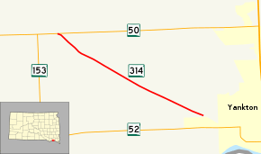
South Dakota Highway 314 (SD 314) is a 3.751-mile-long (6.037 km) state highway in the U.S. state of South Dakota that runs from SD 50 to the western city limits of Yankton. It is maintained by the South Dakota Department of Transportation (SDDOT), and is not part of the National Highway System.
Route description
SD 314 begins at an intersection with SD 50 and heads southeast through flat farmland. The highway continues east for 3.751 miles (6.037 km), reaching its eastern terminus at an intersection with W 11th Street at the western city limits of Yankton.[2][3]
SD 314 is maintained by SDDOT. In 2012, the traffic on the route was measured in average annual daily traffic. SD 314 had an average of 1325 vehicles.[1] The highway is not a part of the National Highway System,[4] a system of highways important to the nation's defense, economy, and mobility.[5]
Major intersections
The entire route is in Yankton County.
| Location | mi[1] | km | Destinations | Notes | |
|---|---|---|---|---|---|
| West Yankton | 0.000 | 0.000 | Western terminus | ||
| Yankton | 3.751 | 6.037 | W 11th Street | Eastern terminus | |
| 1.000 mi = 1.609 km; 1.000 km = 0.621 mi | |||||
References
- 1 2 3 "State Highway Log" (PDF). South Dakota Department of Transportation. January 2012. Retrieved March 3, 2013.
- ↑ Google (March 3, 2013). "South Dakota Highway 314" (Map). Google Maps. Google. Retrieved March 3, 2013.
- ↑ South Dakota Atlas & Gazetteer. Yarmouth, ME: DeLorme. 2009. p. 70. ISBN 0-89933-330-3.
- ↑ National Highway System: South Dakota (PDF) (Map). Federal Highway Administration. October 1, 2012. Retrieved March 3, 2013.
- ↑ Natzke, Stefan; Neathery, Mike; Adderly, Kevin (September 26, 2012). "What is the National Highway System?". National Highway System. Federal Highway Administration. Retrieved March 3, 2013.
External links
Route map: