U.S. Route 35
| ||||||||||
|---|---|---|---|---|---|---|---|---|---|---|
 | ||||||||||
| Route information | ||||||||||
| Length | 417.73 mi[lower-alpha 1] (672.27 km) | |||||||||
| Major junctions | ||||||||||
| South end |
| |||||||||
| ||||||||||
| North end |
| |||||||||
| Location | ||||||||||
| States | West Virginia, Ohio, Indiana | |||||||||
| Highway system | ||||||||||
| ||||||||||

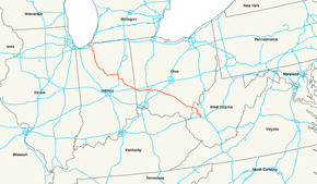
U.S. Route 35 (US 35) is a United States Highway that runs southeast–northwest for approximately 412 miles (663 km) from the western suburbs of Charleston, West Virginia to northern Indiana. Although the highway is physically southeast–northwest, it is nominally north–south. The highway's southern terminus is in Scott Depot, West Virginia, at Interstate 64 (I-64).[5] Its northern terminus is in Michigan City, Indiana, at US 20. Currently, the West Virginia portion of the highway is being expanded to four lanes, mostly along a completely new route. The Ohio portion has already been upgraded to a four-lane highway/freeway between the West Virginia state line and Trotwood, west of Dayton.
Route description
US 35 is signed north–south in West Virginia and Indiana, while in Ohio, it is signed east–west.
West Virginia
_in_Couch%2C_Mason_County%2C_West_Virginia.jpg)
In West Virginia from Scott Depot to Point Pleasant, US 35 is currently being expanded to a four-lane expressway. US 35's junction with I-64 is a hybrid semi-directional T/diamond interchange. There are two intersections north of I-64, followed by an interchange with WV 34. Currently the route is four lanes from I-64 to the junction with the bridge to Buffalo (West Virginia Route 869, WV 869), which serves the large Toyota engine and transmission plant in Buffalo, and continues as a two-lane route for 14.6 miles (23.5 km) to another four-lane, eight-mile (13 km) section to the Ohio River, which is the state line.
The remaining 14.6-mile (23.5 km) gap had a $174 million contract awarded for its completion on June 2, 2015. The section will tentatively be completed by fall of 2019.[6] A possibility of completion as a toll road had been put forward before funding was made available.
Officially, US 35's new alignment begins at exit 40 on I-64 near Scott Depot, from which point US 35 proceeds north on its new roadway.[5]
Ohio
US 35 is signed east–west in Ohio, an exception to the numbering scheme for US Highways, which calls for odd-numbered routes to be signed north–south, as is US 35 in West Virginia and Indiana.
US 35 crosses the Ohio River from West Virginia on the Silver Memorial Bridge, and enters Ohio. The first interchange is with State Route 7 (SR 7), just outside the village of Gallipolis, with the highway passing adjacent to the Gallia–Meigs Regional Airport in the village. From there, it continues west–northwesterly as a freeway toward Jackson, with interchanges at SR 160, SR 850, and SR 325. Passing Rio Grande, the highway travels roughly west and then northwest and becomes a four-lane, at-grade expressway when it reaches the Gallia County village of Centerville. This configuration continues until SR 327, where there is a grade-separated, one-quadrant interchange, with the connecting road in the southeast quadrant of the junction. The road resumes as an at-grade expressway, approaching and then skirting the edge of Jackson, until reaching a grade-separated, right-in/right-out interchange with Keystone Furnace Road and McCarty Lane, which was converted from an at-grade intersection in 2015.[7]
Next, there currently exists an unusual interchange configuration at SR 32, which is an expressway in both directions. Each highway has ramps that exit to the other highway, with right-turning traffic merging onto the second highway, but left-turning traffic coming to an at-grade intersection. Both highways end up having at-grade intersections, albeit with a grade separation of the main highway corridors. This interchange type is sometimes termed a "windmill" interchange, but it is not related to the interchange type of the same name. This junction is the only interchange of its type known to exist in the world.
Continuing northwest, the highway reverts to a freeway, continues to bypass and then leaves Jackson until it reaches an interchange with Chillicothe Pike. After this junction, the highway returns to an at-grade expressway, turns roughly west and reaches Richmond Dale. The road then turns northwest. The section between Richmond Dale and Chillicothe was upgraded to a freeway in 2005 and includes a large cut through a 1,000-foot (300 m) ridge. This section of road provides westbound motorists with a panoramic view of the Scioto River valley. The road then bypasses Chillicothe to the east and north, partially running concurrently with US 23, turning west near the Bridge Street exit; travelers eastbound near that exit can see the hills that are shown on the Great Seal of the State of Ohio.
The road turns west–northwest, bypassing south of Washington Court House. The next major junction is with I-71 near Jeffersonville; rather than have a direct interchange, each freeway indirectly connects to the other via interchanges with SR 435. As the route continues through flat farmlands, it bypasses north of Jamestown and south of Xenia. Past the Xenia bypass, the road reverts to an at-grade expressway.
US 35 once again returns to freeway status at the North Fairfield Road interchange in Beavercreek. It next has a full-access interchange with I-675, also in Beavercreek. Several miles later, the road opens into a three-lane highway (with five lanes in some parts) each way through downtown Dayton. Turning west, the highway has a full-access interchange with I-75 in downtown Dayton. Past I-75, the route becomes an expressway, with a mix of interchanges and at-grade intersections.
After entering Drexel, just west of Dayton, the highway turns north. At the border with Trotwood, the route turns due west on West Third Street/Eaton Pike; the roadway which had carried US 35 continues as at-grade expressway SR 49 (the "Northwest Connector" or the "Trotwood Connector"). The roadway carrying US 35, now two lanes and undivided, travels through New Lebanon as Main Street and then West Alexandria as Dayton Street. The route next proceeds to Eaton; after passing through downtown as Main Street, the route turns northwest onto Eaton Richmond Pike (Main Street continues as SR 122). The highway travels toward I-70 near New Paris, widens to four lanes as it approaches SR 320, turns north and briefly becomes four lanes undivided, then reduces to single-lane ramps and merges with the Interstate at a partial interchange. Running concurrently with I-70, US 35 travels approximately two miles (3.2 km) to the Indiana state line.
The portion of US 35 from Drexel to SR 320 is the only two-lane, undivided section of the route remaining in Ohio. US 35 is a major Appalachian Development Highway System Corridor linking I-70 and points west to I-64 and points east.
The portion of the route within Gallia County is designated the "Bob Evans Highway", in honor of the restaurateur and pork sausage marketer who spent most of his life in the county.[8]
The portion of the route between Gallipolis and Jackson is designated as part of the Welsh Scenic Byway by the Ohio Department of Transportation, celebrating Welsh immigrants who settled in southeastern Ohio during the 19th century.[9]
The portion of the route in Dayton west of I-75 is designated the "C. J. McLin Jr. Parkway", in honor of the late state representative who advocated and worked toward the construction of "US 35 West".[10][11]
Indiana
US 35 enters Indiana with I-70 and passes north of Richmond, before splitting off on the northwest side of Richmond. US 35 then travels in a northwesterly path as a winding two-lane highway, passing through agricultural land, and through intersections with State Road 38 (SR 38), SR 1 and US 36.
The highway reaches the edge of the city of Muncie, where it merges with SR 3 and SR 67 as a four-lane expressway. The expressway heads north, skirting the east side of Muncie, passing over the White River and through interchanges with Memorial Drive in unincorporated Center Township and SR 32 in Muncie. Continuing along the east edge of Muncie, there is a right-in/right-out intersection in both directions with East Centennial Avenue and an intersection with East McGalliard Road. Northeast of Muncie, at the border of unincorporated Center Township and Hamilton Township, there is an intersection with East Riggin Road. Shortly thereafter, SR 67 splits off the expressway at an interchange, followed by a partial interchange with Old State Road 3, leading back into Muncie. Soon after the expressway ends, with the roadway becoming a two-lane highway.
Near the town of Royerton, US 35 turns west onto SR 28, toward I-69, as SR 3 continues north. After a short overlap with SR 28, US 35 turns north onto I-69.
US 35 overlaps I-69, passing through an interchange with SR 26, to SR 22, where US 35 leaves I-69 and heads west on SR 22 to travel through the cities of Gas City and Greentown. Just east of Kokomo US 35 turns north onto the US 31 freeway. It overlaps US 31 for only 4.5 miles (7.2 km), to a partial interchange where it splits off, heading west as a two-lane roadway. US 35 passes just north of a Chrysler manufacturing plant before an intersection with SR 931, the former route of US 31. The roadway briefly widens to a four-lane divided highway at a partial interchange with Davis Road, which connects from Kokomo. US 35 leaves the Kokomo area heading northwest, toward Logansport.
As US 35 nears Logansport, the roadway becomes a four-lane expressway, just prior to its intersection with US 24. The expressway bypasses Logansport to the south as part of the Hoosier Heartland Highway. There is a northbound (westbound) exit to Monticello Road, the former routing of these highways. Northbound US 35 and westbound US 24 exit the Hoosier Heartland Highway at a split diamond interchange and run concurrently along the interchange's westbound one-way frontage road, having a very short overlap with SR 25 (southbound US 35 and eastbound US 24 run concurrently along the eastbound one-way frontage road, also overlapping SR 25). US 35 and US 24 then turn northwest from the frontage road onto another expressway on the west edge of Logansport. Along the roadway, there is an intersection with the aforementioned Monticello Road and a two-quadrant interchange with Old State Road 25. After crossing the Wabash River, the overlapped routes have a final interchange where US 24 exits heading due west, while US 35 continues north-northwest.
Soon after US 24 leaves US 35, US 35 narrows back to a two-lane road and travels through the towns of Winamac and Knox. In Davis Township, Starke County, near Hamlet, the US 30 expressway provides an interchange. After entering LaPorte County, US 35 travels to the community of South Center in Union Township; there it turns west on US 6 (the US 35 roadway continues north as South County Road 300 E). The route next turns north-northwest until it leaves the concurrency with US 6 northward in Washington Township, near Kingsbury. Turning northwest, US 35 travels through the city of La Porte; in northwestern La Porte, an intersection with SR 39 provides access to the Indiana Toll Road/I-80/I-90. US 35 next crosses under the Indiana Toll Road with no direct interchange access, in unincorporated Center Township. Farther northwest, US 35 meets and turns west-northwest on US 20 in Springfield Township, just east of an interchange with I-94. Approximately 1 mile (1.6 km) beyond the I-94 interchange, US 35 terminates at an interchange including itself, US 20, SR 212 and Michigan Boulevard in Michigan City; the US 35 roadway continues as Michigan Boulevard.
Logansport issues
Logansport area residents, the sheriff's department and at least one transportation expert have voiced concerns about the split diamond interchange used on the Logansport section of the Hoosier Heartland Highway. From the interchange's opening in October 2013 through February 28, 2016, there had been 71 two-vehicle crashes at or near the interchange, 53 of those at the interchange's four intersections, two fatalities, and a number of injuries. Possible causes for the accidents include drivers' unfamiliarity with this type of interchange, which is typically built in cities, and is not common in semi-rural small towns; drivers' mistaking the frontage roads for entrance ramps and not stopping when required; the complexity of four major traffic routes converging on one interchange; ramp/frontage traffic controlled by stop signs alone, with cross-traffic not having to stop; stop signs not clearly visible at the crest of the exit ramps. In response, the Indiana Department of Transportation (INDOT) in 2014 added signage, placed flashing lights on the stop signs and installed rumble strips. These steps reduced, but did not eliminate the problems, with one of the fatalities taking place after these fixes. INDOT was planning by spring 2016 to add overhead flashers, move the stop signs to more visible positions, install channelizing islands and increase overhead intersection lighting.[12]
History
West Virginia
Originally, US 35 was routed from Charleston, West Virginia, on the north side of the Kanawha River (the current WV 62) to Point Pleasant until the collapse of the Silver Bridge in 1967. When the new Silver Memorial Bridge was completed in 1969, US 35 was moved to the south side of the river (the former WV 17) away from Point Pleasant, and its terminus was in St. Albans, West Virginia, at the junction of US 60.
As of June 15, 2009, the old segment of US 35 between Buffalo Bridge, West Virginia, and US 60 is now signed as WV 817.
Ohio
Before the adoption of the U.S. Highway System in 1926, the route in Ohio was known in its entirety as SR 11.[13] By 1966, the first freeway portion of the route began construction, comprising the Chillicothe bypass.[14] Freeway portions on the east side of Dayton and south side of Xenia were completed by 1971,[15] and around Washington Court House by 1974.[16] Before 1988, westbound traffic on US 35 west of I-75 in Dayton turned north along Williams Street, then was routed along West Third Street (eastbound traffic on West Third Street turned south on Broadway Street back to US 35); on October 25, 1996, a new expressway alignment through west Dayton, known as the "US 35 West" project, was completed.[10][11]
Indiana
The first signed road along the what would later become US 35 was SR 35, which ran from west of Jonesboro and Kokomo, and SR 15 from Burlington to Michigan City. In 1926 state road numbers were changed; SR 35 became SR 18 and SR 15 became SR 29.[17] Many changes took place in 1930 along what would later became US 35, the first of which was a state road proposed between SR 38, near Richmond, and Muncie. This was followed by SR 21 being added to the state road system between Muncie and St. Anthony, and a state road being proposed between St. Anthony and SR 9 west of Jonesboro. The last change in 1930 was a proposed state road between Kokomo and Burlington.[18][19]
Between late 1930 and early 1932 SR 21 was added to the state road system between SR 38 and Muncie and between St. Anthony and Jonesboro. At the same time SR 18 became SR 22 and was extended east through Jonesboro and west to Burlington. Also during this time frame a state road was proposed between Kokomo and Logansport.[19][20] In late 1932 or early 1933 SR 21 was paved between Richmond and Muncie and SR 22 was paved between Kokomo and Burlington.[21][22]
US 35 was first designated in the state of Indiana in 1935, US 35 was routed from the Ohio state line, near Richmond, to Michigan City, via Muncie, Kokomo, Burlington and Logansport, along SR 21, SR 22 and SR 29.[23][24] At this time the Indiana State Highway Commission authorized the addition of SR 17 between Kokomo and Logansport. The construction on the authorized segment of SR 17 began between 1939 and 1941, with the construction being completed by 1942.[25][26][27] US 35 was rerouted away from Kingsbury between 1942 and 1945, with the old route through the town becoming SR 829.[27][28]
The multi-lane road of US 35 from US 6 to La Porte opened either in 1951 or 1952.[29][30] The US 35 designation was rerouted onto SR 3 and SR 28 between Munice and St. Anthony between 1956 and 1957.[31][32] The old route of US 35 became locally maintained roads and streets. The bypass of Jonesboro was completed in either 1965 or 1966, and US 35 was routed along it from SR 15 to the west; east of SR 15 was signed as only SR 22.[33][34] In 1967 or 1968 US 35 was rerouted onto SR 28, I-69, and SR 22 from St. Anthony to Jonesboro. The old route of US 35 became county roads or city streets.[35][36]
By 1970 US 35 was rerouted onto US 31 (now SR 931) to bypass downtown Kokomo.[37][38] US 35 was rerouted onto SR 3 to bypass downtown Muncie between 1972 and 1973.[39][40] By 1974 US 35 was rerouted away from downtown Logansport on the a bypass around the south and east sides of the city.[40][41] The US 35 designation in Richmond was moved onto I-70 between 1997 and 1999. In October 2008 the Indiana Department of Transportation and the City of Michigan City came to an agreement for the city to assume maintenance of US 35 from the US 20/SR 212 interchange to US 12.[42] INDOT submitted an application in October 2008 to the American Association of State Highway and Transportation Officials (AASHTO) for the removal of US 35 between US 12 and the east junction of US 20. INDOT still has US 35 overlapping US 20 to the interchange between SR 212 and US 20.[43][44] The city took over maintenance of the segment of US 35 in October 2009, and it became known as Michigan Boulevard.[42][45] New bypass roads in Kokomo and Logansport opened in 2013 and US 35 was rerouted along both new roadways.[46][47][48]
Major intersections
| State | County | Location | mi[lower-alpha 2] | km | Exit[49] | Destinations | Notes | |
|---|---|---|---|---|---|---|---|---|
| West Virginia | Putnam | Teays Valley | −0.20 | −0.32 | Continuation as unsigned US 35 Spur | |||
| 0.00 | 0.00 | Southern end of expressway | ||||||
| — | Southern end of US 35; hybrid semi-directional T/diamond interchange; all movements between US 35 and I-64 are free-flowing except for eastbound I-64 to northbound US 35; I-64 exit 40 | |||||||
| | 2.5 | 4.0 | — | Interchange | ||||
| | 5.8 | 9.3 | Intersection | |||||
| | 11.3 | 18.2 | Northern end of expressway | |||||
| | 12.4 | 20.0 | Intersection; western end of WV 869 | |||||
| | 12.5 | 20.1 | Intersection; southern end of WV 817 overlap | |||||
| Mason | Beech Hill | 26.5 | 42.6 | Intersection; northern end of WV 817 overlap | ||||
| | 26.7 | 43.0 | Southern end of expressway | |||||
| | 33.5 | 53.9 | Intersection | |||||
| | 35.8 | 57.6 | Northern end of expressway; southern end of freeway | |||||
| — | ||||||||
| Ohio River | 36.58 174.433 | 58.87 280.723 | Silver Memorial Bridge; West Virginia–Ohio state line | |||||
| Ohio | Gallia | Gallipolis Township | 174.238 | 280.409 | — | Westbound exit and eastbound entrance | ||
| 173.769 | 279.654 | — | Eastbound left exit and westbound left entrance; western end of SR 735 | |||||
| Gallipolis–Green township line | 170.647– 169.975 | 274.630– 273.548 | — | No eastbound exit | ||||
| Springfield Township | 169.319 | 272.493 | — | Eastbound exit and westbound entrance | ||||
| 165.473 | 266.303 | — | ||||||
| Raccoon Township–Rio Grande line | 160.679 | 258.588 | — | |||||
| Western end of freeway; eastern end of expressway | ||||||||
| Raccoon Township | 157.596 | 253.626 | Intersection; eastern end of SR 279 | |||||
| Jackson | Bloomfield Township | 148.248 | 238.582 | One-quadrant interchange with connecting roadway in the southeast quadrant; southern end of SR 327 | ||||
| Lick Township–Jackson line | 143.868 | 231.533 | — | McCarty Lane / Keystone Furnace Road | Westbound right-in/right-out at Keystone Furnace Road; eastbound right-in/right-out at McCarty Lane; roads connected by Acy Avenue overpass | |||
| Lick Township | 142.863 | 229.916 | — | "Windmill" interchange | ||||
| 142.268 | 228.958 | Western end of expressway; eastern end of freeway | ||||||
| — | Pattonsville Road / Broadway Street | |||||||
| 140.728 | 226.480 | — | ||||||
| Coal–Liberty township line | 138.418 | 222.762 | — | County Road 84 (Chillicothe Pike) / Jackson Business Route | Jackson Business Route signed eastbound only | |||
| Western end of freeway; eastern end of expressway | ||||||||
| Ross | Jefferson Township | 126.368 | 203.370 | Western end of expressway; eastern end of freeway | ||||
| — | Vigo Road / Watson Road – Richmond Dale | |||||||
| Liberty–Springfield township line | 117.388 | 188.918 | — | Eastern end of US 50 overlap | ||||
| Scioto Township | 115.858 | 186.455 | — | Western end of US 50 overlap; westbound exit and eastbound entrance | ||||
| 115.218 | 185.425 | — | Eastern end of US 23 overlap; eastbound exit and westbound entrance | |||||
| Scioto Township–Chillicothe line | 113.948 | 183.382 | — | |||||
| Scioto Township | 112.908 | 181.708 | — | Western end of US 23 overlap; westbound exit and eastbound entrance | ||||
| Scioto Township–Chillicothe line | 112.068 | 180.356 | — | |||||
| Scioto Township | 110.858 | 178.409 | — | |||||
| Union Township | 108.978 | 175.383 | — | Westbound exit and eastbound entrance | ||||
| 107.068 | 172.309 | — | County Road 550 – Pleasant Valley | |||||
| Concord Township | 100.088 | 161.076 | — | County Road 87 – Frankfort | ||||
| 97.088 | 156.248 | — | ||||||
| Fayette | Union Township | 85.531 | 137.649 | 85 | ||||
| 83.672 | 134.657 | 83 | ||||||
| 82.517– 82.084 | 132.798– 132.101 | 82 | Ramps connect to a pair of two-way frontage roads, each of which runs between US 62 and US 22/SR 3 | |||||
| 80.169 | 129.019 | 80 | Palmer Road | |||||
| Jasper–Jefferson township line | 72.666 | 116.945 | — | Westbound exit and eastbound entrance; I-71's interchange with SR 435 lies between US 35's two interchanges with SR 435 | ||||
| Jefferson Township | 70.361 | 113.235 | — | Eastbound exit and westbound entrance; western end of SR 435 | ||||
| Greene | Jamestown | 63.766 | 102.621 | 64 | ||||
| Silvercreek Township | 62.012 | 99.799 | 62 | Old US 35 – Jamestown | ||||
| Xenia Township | 55.538 | 89.380 | 55 | Bickett Road (US 35 Bus.) | ||||
| Xenia Township–Xenia line | 53.125 | 85.496 | 53 | |||||
| 51.221– 51.203 | 82.432– 82.403 | 51 | Signed as exits 51B (north) and 51A (south) | |||||
| Xenia | 50.522 | 81.307 | 50 | Lower Bellbrook Road | ||||
| Xenia–Xenia Township– Beavercreek Township tripoint | 48.243 | 77.640 | 48 | US 35 west merges onto US 35 Bus. roadway; US 35 east has a left exit to US 35 Bus. | ||||
| Western end of freeway; eastern end of expressway | ||||||||
| Beavercreek | 43.750– 43.421 | 70.409– 69.879 | Western end of expressway; eastern end of freeway | |||||
| 44 | Eastern end of SR 835; eastbound US 35 is signed for North Fairfield Road only | |||||||
| 42.778 | 68.845 | 43 | Eastbound exit only | |||||
| 41.648 | 67.026 | 42 | Westbound US 35 uses collector–distributor lane; exits 13A and 13B on I-675 | |||||
| Greene–Montgomery county line | Beavercreek–Riverside city line | 41.179 | 66.271 | — | Dayton–Xenia Road / Linden Avenue | Eastbound exit and westbound entrance | ||
| Montgomery | Riverside | 40.020 | 64.406 | — | Western end of SR 835 | |||
| Dayton | 39.000 | 62.764 | — | Smithville Road | ||||
| 37.840 | 60.898 | — | Steve Whalen Boulevard | |||||
| 36.940 | 59.449 | — | Keowee Street / Wayne Avenue | Westbound exit is attached to Steve Whalen Boulevard exit; access from northbound Keowee Street to westbound US 35 via Wayne Avenue | ||||
| 36.290– 36.190 | 58.403– 58.242 | — | ||||||
| 35.970 | 57.888 | — | Ludlow Street / Perry Street | |||||
| 35.660 | 57.389 | Bridge over the Great Miami River | ||||||
| 35.290 | 56.794 | — | Stewart Street | I-75 exit 52; eastern end of SR 4 overlap (ODOT makes this claim; signage would appear to disagree); ramps to southbound I-75 and from northbound I-75 include entrances and exits for Stewart Street | ||||
| 34.310 | 55.217 | — | James H. McGee Boulevard | |||||
| Western end of freeway; eastern end of expressway | ||||||||
| 33.470 | 53.865 | Abbey Avenue | Intersection; the Wright Company factory site, which later housed the Dayton-Wright Company, is located at the corner of Abbey Avenue and West Third Street | |||||
| 32.590 | 52.449 | — | Interchange; western end of SR 4 overlap (ODOT makes this claim; signage would appear to disagree) | |||||
| 31.680 | 50.984 | Liscum Drive | Intersection | |||||
| Jefferson Township (Drexel) | 30.980 | 49.857 | Infirmary Road | Intersection | ||||
| Jefferson Township (Drexel)—Trotwood line | 30.220 | 48.634 | US 35 turns west on West Third Street/Eaton Pike; roadway continues as at-grade expressway SR 49; southern end of SR 49 | |||||
| Western end of expressway | ||||||||
| Preble | West Alexandria | 17.220 | 27.713 | |||||
| Eaton | 11.920 | 19.183 | Eastern end of SR 122 overlap | |||||
| 11.680 | 18.797 | Northern end of SR 732 | ||||||
| 11.420 | 18.379 | Western end of SR 122 overlap; US 35 turns northwest off Main Street as Eaton Richmond Pike | ||||||
| Jackson Township | 2.380 | 3.830 | Southern end of SR 320 | |||||
| Jackson–Jefferson township line | 1.660 | 2.672 | Eastern end of freeway | |||||
| 1 | Eastern end of I-70 overlap; US 35 west merges onto freeway; eastbound exit and westbound entrance; exit 1 on I-70 | |||||||
| 0.000 | 0.000 | Ohio–Indiana state line | ||||||
| Indiana | Wayne | Wayne Township | 0.257 | 0.414 | 156 | Exit 156 on I-70; signed as exits 156B (east) and 156A (west) | ||
| 3.585 | 5.769 | 153 | Exit 153 on I-70 | |||||
| 5.155 | 8.296 | 151 | Single-point urban interchange; exit 151 on I-70 | |||||
| 7.093 | 11.415 | 149B | Northern end of I-70 overlap; US 35 north departs freeway; US 35 south merges with freeway, roadway continues as Williamburg Pike/Tom Raper Way; exit 149B on I-70 | |||||
| Northern end of freeway | ||||||||
| Webster Township | 8.366 | 13.464 | Eastern end of SR 38 | |||||
| Dalton Township | 23.001 | 37.017 | ||||||
| Randolph | Union Township | 27.055 | 43.541 | |||||
| Henry |
No major junctions | |||||||
| Delaware | Center Township–Muncie line | 40.904 | 65.829 | Southern end of expressway | ||||
| — | Interchange; southern end of SR 3/SR 67 overlap; US 35 north merges onto expressway; no access from US 35 north to SR 3 south / SR 67 south or SR 3 north / SR 67 north to US 35 south | |||||||
| Center Township | 42.508 | 68.410 | — | Memorial Drive | Interchange | |||
| Muncie | 43.506 | 70.016 | — | Interchange | ||||
| Hamilton Township | 47.010 | 75.655 | — | Interchange; northern end of SR 67 overlap | ||||
| 47.650 | 76.685 | — | Muncie (Old State Road 3 south) – Ball State University | Interchange; southbound exit and northbound entrance | ||||
| Northern end of expressway | ||||||||
| 49.899 | 80.305 | Northern end of SR 3 overlap; southern end of SR 28 overlap | ||||||
| Harrison Township | 59.924 | 96.438 | Southern end of freeway | |||||
| 245 | Southern end of I-69 overlap; northern end of SR 28 overlap; US 35 merges onto freeway; exit 245 on I-69 | |||||||
| Grant | Jefferson Township | 70.157 | 112.907 | 255 | Exit 255 on I-69 | |||
| Gas City–Jefferson Township– Monroe Township tripoint | 74.241 | 119.479 | 259 | Northern end of I-69 overlap; southern end of SR 22 overlap; US 35 departs freeway; exit 259 on I-69 | ||||
| Northern end of freeway | ||||||||
| Jonesboro | 78.546 | 126.408 | Southern end of SR 15 | |||||
| Mill–Franklin township line | 81.105 | 130.526 | ||||||
| Franklin Township | 82.221 | 132.322 | ||||||
| Sims Township | 89.138 | 143.454 | Southern end of SR 19 overlap | |||||
| Howard | Greentown | 96.099 | 154.656 | Northern end of SR 213 | ||||
| Howard–Taylor township line | 100.033 | 160.988 | Northern end of SR 19 overlap | |||||
| 102.898 | 165.598 | Southern end of freeway | ||||||
| 162 | Southern end of US 31 overlap; western end of SR 22 overlap; western end of the eastern segment of SR 22; US 35 merges onto freeway; exit 162 on US 31 | |||||||
| Center Township | 105.968 | 170.539 | 165 | Touby Pike – Airport | Exit 165 on US 31 | |||
| Howard Township | 107.361 | 172.781 | 166 | Northern end of US 31 overlap; northbound exit and southbound entrance; US 35 departs freeway; exit 166 on US 31 | ||||
| Northern end of freeway | ||||||||
| Howard–Clay township line | 108.229 | 174.178 | ||||||
| Clay Township | 110.415 | 177.696 | — | Kokomo, Downtown (Davis Road) | Interchange; southbound exit and northbound entrance | |||
| Cass | Galveston | 113.356 | 182.429 | |||||
| Walton | 119.925 | 193.001 | ||||||
| Washington Township | 125.940 | 202.681 | Southern end of expressway | |||||
| Intersection; southern end of US 24 overlap | ||||||||
| Logansport | 129.207 | 207.939 | — | No Name (Monticello Road) | Interchange; northbound exit only; former US 24 west / US 35 north | |||
| Washington Township | 129.854 | 208.980 | Northern end of expressway | |||||
| — | Split diamond interchange, together with interchange for SR 25 south; southern end of SR 25 overlap; northern end of SR 329; US 35 departs expressway and travels along frontage road | |||||||
| Washington Township–Logansport line | 130.129 | 209.422 | — | Split diamond interchange, together with interchange for SR 25 north; northern end of SR 25 overlap; US 35 turns north from frontage road onto other expressway | ||||
| Southern end of expressway | ||||||||
| Logansport–Eel Township line | 130.929 | 210.710 | — | Old State Road 25 | Two-quadrant interchange | |||
| Eel–Noble township line | 132.287 | 212.895 | — | Interchange; northern end of US 24 overlap | ||||
| Northern end of expressway | ||||||||
| Royal Center | 141.679 | 228.010 | ||||||
| Pulaski | Winamac | 155.561 | 250.351 | Northern end of the southern section of SR 119 | ||||
| 156.058 | 251.151 | Southern end of SR 14 overlap | ||||||
| 156.184 | 251.354 | Northern end of SR 14 overlap | ||||||
| Starke | California Township | 166.257 | 267.565 | Southern end of SR 10 overlap | ||||
| 167.638 | 269.787 | Northern end of SR 10 overlap | ||||||
| Knox | 172.655 | 277.861 | Southern end of SR 8 overlap | |||||
| Center Township | 174.659 | 281.086 | Northern end of SR 8 overlap | |||||
| Davis Township | 179.953 | 289.606 | This junction is an interchange on the US 30 expressway | |||||
| LaPorte | South Center | 186.239 | 299.723 | Southern end of US 6 overlap; US 35 turns west onto US 6; roadway continues as South County Road 300 E | ||||
| Washington Township | 191.181 | 307.676 | Northern end of US 6 overlap; US 35 turns north | |||||
| La Porte | 198.058 | 318.743 | Southern end of SR 39 overlap | |||||
| 199.947 | 321.784 | Northern end of SR 39 overlap | ||||||
| Springfield Township | 205.440 | 330.624 | Eastern end of US 20 overlap | |||||
| 205.732 | 331.094 | Cloverleaf interchange | ||||||
| Michigan City | 206.716 | 332.677 | Michigan Boulevard | Northern end of US 35; western end of US 20 overlap; roadway continues as Michigan Boulevard | ||||
1.000 mi = 1.609 km; 1.000 km = 0.621 mi
| ||||||||
Related routes
West Virginia spur route
| |
|---|---|
| Location | Teays Valley, West Virginia |
| Length | 0.20 mi[1] (0.32 km) |
U.S. Route 35 Spur (US 35 Spur) is the unsigned continuation of US 35 past its southern end at I-64.
Xenia business route
| |
|---|---|
| Location | Xenia, Ohio |
| Length | 5.7 mi[50] (9.2 km) |
See also
Notes
References
- 1 2 3 "All Routes" (ESRI shapefile). West Virginia Department of Transportation. June 20, 2017. Retrieved August 23, 2017.
- 1 2 Google (August 23, 2017). "US 35 in West Virginia" (Map). Google Maps. Google. Retrieved August 23, 2017.
- 1 2 "Roadway Description Inventory Report — DESTAPE". Ohio Department of Transportation. March 6, 2017. Retrieved August 23, 2017.
- Gallia County (PDF)
- Jackson County (PDF)
- Ross County (PDF)
- Fayette County (PDF)
- Greene County (PDF)
- Montgomery County (PDF)
- Preble County (PDF)
- 1 2 Indiana Department of Transportation (July 2015). Reference Post Book (PDF). Indianapolis: Indiana Department of Transportation. I-69, I-70, US 24, US 31, US 35. Retrieved August 23, 2017.
- 1 2 "West Virginia US 35 Deletion Request" (PDF). West Virginia Department of Transportation. Retrieved October 11, 2008 – via American Association of State Highway and Transportation Officials.
- ↑ "More Than $174 Million Contract Awarded to Finish U.S. 35 in W.Va". WSAZ-TV. Retrieved June 2, 2015.
- ↑ Staff (August 26, 2015). "Keystone Furnace Road reopens". The Jackson County Telegram. Retrieved August 26, 2017.
- ↑ "5533.83 Bob Evans Highway". Ohio Revised Code. May 18, 2005. Retrieved August 29, 2017 – via LAW Writer.
- ↑ Ohio Department of Transportation. "Ohio Scenic Byways: Welsh". Ohio Department of Transportation. Retrieved August 29, 2017.
- 1 2 Staff (October 20, 1996). "The Chronology of U.S. 35 West". Dayton Daily News. Retrieved September 2, 2017 – via NewsBank.
- 1 2 Ali, Derek (October 26, 1996). "New Section of U.S. 35 Opens". Dayton Daily News. Retrieved September 2, 2017 – via NewsBank.
- ↑ Gerber, Carson (February 28, 2016). "Hoosier Heartland Highway: A dangerous road". Kokomo Tribune. Retrieved December 16, 2017.
- ↑ Ohio Department of Highways and Public Works (August 1925). Map of Ohio Showing State Routes (PDF) (Map). 1:760,320. Columbus: Ohio Department of Highways and Public Works. OCLC 5673562.
- ↑ Ohio Department of Highways (1966). Official Highway Map (PDF) (Map). c. 1:563,200. Columbus: Ohio Department of Highways. § G13. OCLC 5673562.
- ↑ Ohio Department of Highways (1971). Official Highway Map (PDF) (Map). 1:554,400. Columbus: Ohio Department of Highways. §§ C12–D12. OCLC 5673562.
- ↑ Ohio Department of Transportation (1974). Ohio Transportation Map (PDF) (Map). 1:554,400. Columbus: Ohio Department of Transportation. § F12. OCLC 5673562.
- ↑ "Road Numbers to Be Changed". The Hancock-Democrat. September 30, 1926. Retrieved August 24, 2017 – via Newspapers.com.

- ↑ Indiana State Highway Commission (1930). State Highway System of Indiana (Map). Indiana State Highway Commission. Retrieved August 23, 2017 – via Indiana State Library and Historical Bureau.
- 1 2 Indiana State Highway Commission (August 1, 1930). State Highway System of Indiana (Map). Indiana State Highway Commission. Retrieved August 23, 2017 – via Indiana State Library and Historical Bureau.
- ↑ Indiana State Highway Commission (January 1, 1932). State Highway System of Indiana (Map). 1:660,000. Indianapolis: Indiana State Highway Commission. OCLC 53092152. Retrieved August 23, 2017 – via Indiana State Library and Historical Bureau.
- ↑ Indiana State Highway Commission (September 30, 1932). State Highway System of Indiana (PDF) (Map). Indianapolis: Indiana State Highway Commission. Retrieved August 24, 2017 – via Indiana University Bloomington Libraries.
- ↑ Indiana State Highway Commission (February 1933). State Highway System of Indiana (Map). 1:618,000. Indiana State Highway Commission. OCLC 53355434. Retrieved August 24, 2017 – via Indiana State Library and Historical Bureau.
- ↑ "Seven Changes in Route Numbers on Indiana Highways". The Rushville Republican. February 18, 1935. pp. 1, 6. Retrieved August 23, 2017 – via Newspapers.com.
- ↑ "Alter Numbers of Seven State Roads". The Daily Clintonian. February 18, 1935. p. 1. Retrieved August 23, 2017 – via Newspapers.com.
- ↑ Indiana State Highway Commission (1939). State Highway System of Indiana (Map). 1:633,600. Indiana State Highway Commission. OCLC 64016573. Retrieved August 23, 2017 – via Indiana State Library and Historical Bureau.
- ↑ Indiana State Highway Commission (1941). State Highway System of Indiana (Map). 1:633,600. Indiana State Highway Commission. OCLC 64574634. Retrieved August 23, 2017 – via Indiana State Library and Historical Bureau.
- 1 2 Indiana State Highway Commission (1942). State Highway System of Indiana (Map). 1:720,000. Indiana State Highway Commission. OCLC 64382867. Retrieved August 23, 2017 – via Indiana State Library and Historical Bureau.
- ↑ Indiana State Highway Commission (1945). State Highway System of Indiana (Map). 1:633,600. Indiana State Highway Commission. OCLC 123132182. Retrieved August 23, 2017 – via Indiana State Library and Historical Bureau.
- ↑ Indiana State Highway Commission (1951). State Highway System of Indiana (Map). 1:660,000. Indiana State Highway Commission. OCLC 64558142. Retrieved August 23, 2017 – via Indiana State Library and Historical Bureau.
- ↑ Indiana State Highway Commission (1952). State Highway System of Indiana (Map). 1:660,000. Indiana State Highway Commission. OCLC 55533635. Retrieved August 23, 2017 – via Indiana State Library and Historical Bureau.
- ↑ Indiana State Highway Department (1956). State Highway System of Indiana (Map). 1:660,000. Indiana State Highway Department. OCLC 64383090. Retrieved August 23, 2017 – via Indiana State Library and Historical Bureau.
- ↑ Indiana State Highway Department (1957). State Highway System of Indiana (Map). Indiana State Highway Department. OCLC 78547924. Retrieved August 23, 2017 – via Indiana State Library and Historical Bureau.
- ↑ Indiana State Highway Commission (1965). Indiana State Highway System (Map) (1965–1966 ed.). 1:630,980. Indiana State Highway Commission. OCLC 53370381. Retrieved August 23, 2017 – via Indiana State Library and Historical Bureau.
- ↑ Indiana State Highway Commission (1966). Indiana State Highway System (Map) (1966–1967 ed.). 1:640,000. Indiana State Highway Commission. OCLC 65209231. Retrieved August 23, 2017 – via Indiana State Library and Historical Bureau.
- ↑ Indiana State Highway Commission (1967). Indiana State Highway System (Map) (1967–1968 ed.). 1:640,000. Indiana State Highway Commission. OCLC 65221593. Retrieved August 23, 2017 – via Indiana State Library and Historical Bureau.
- ↑ Indiana State Highway Commission (1968). Indiana State Highway System (Map) (1968–1969 ed.). 1:640,000. Indiana State Highway Commission. OCLC 65221736. Retrieved August 23, 2017 – via Indiana State Library and Historical Bureau.
- ↑ Indiana State Highway Commission (1969). Indiana State Highway System (Map). 1:631,000. Indiana State Highway Commission. OCLC 314731307. Retrieved August 24, 2017 – via Indiana State Library and Historical Bureau.
- ↑ Indiana State Highway Commission (1970). Indiana State Highway System (Map) (1970–1971 ed.). 1:640,000. Indiana State Highway Commission. OCLC 65221477.
- ↑ Indiana State Highway Commission (1972). Indiana State Highway System (Map) (1972–1973 ed.). 1:640,000. Indiana State Highway Commission. OCLC 65333830.
- 1 2 Indiana State Highway Commission (1973). Indiana State Highway System (Map) (1973–1974 ed.). 1:633,900. Indiana State Highway Commission. OCLC 501330315, 65333444.
- ↑ Indiana State Highway Commission (1974). Indiana State Highway System (Map) (1974–1975 ed.). 1:640,000. Indiana State Highway Commission. OCLC 65332954.
- 1 2 "Boulevard Soon Under City's Control". The News Dispatch. Michigan City, IN. August 17, 2008. Retrieved August 22, 2017.
- ↑ Indiana Department of Transportation (August 25, 2008). "An Application from the State Highway or Transportation Department of Indiana" (PDF). Indiana Department of Transportation. Retrieved August 23, 2017 – via American Association of State Highway and Transportation Officials.
- ↑ Indiana Department of Transportation (July 2016). Reference Post Book (PDF). Indianapolis: Indiana Department of Transportation. US 35. Retrieved August 23, 2017.
- ↑ "City to Get Check for 'Boulevard'". The News Dispatch. Michigan City, IN. October 29, 2008. Retrieved August 22, 2017.
- ↑ "New US 31 Bypass Opens in Kokomo". South Bend Tribune. Associated Press. November 26, 2013. Retrieved August 30, 2017.
- ↑ Kirk, Mitchell (October 24, 2013). "Officials Celebrate Hoosier Heartland Opening Connecting Fort Wayne and Lafayette". Indiana Economic Digest. Retrieved August 30, 2017.
- ↑ Fetting, Brian (October 17, 2013). "Entire Hoosier Heartland Highway Open Friday". Indianapolis, IN: WTHR-TV. Retrieved August 30, 2017.
- ↑ District 8 (September 18, 2014). "D08-SIGN-FY2015" (PDF). Ohio Department of Transportation. PID: 87029, Federal Project No. E110(748), Contract Number: 148032. Retrieved September 2, 2017.
- ↑ Google (August 24, 2017). "Xenia Business Route" (Map). Google Maps. Google. Retrieved August 24, 2017.
External links
| Wikimedia Commons has media related to U.S. Route 35. |
Routes in italics are no longer a part of the system. Highlighted routes are considered main routes of the system. |