U.S. Route 24 in Indiana
| ||||
|---|---|---|---|---|
_map.svg.png) US 24 highlighted in red | ||||
| Route information | ||||
| Maintained by INDOT | ||||
| Length | 166.846 mi[1] (268.513 km) | |||
| Major junctions | ||||
| West end |
| |||
|
| ||||
| East end |
| |||
| Location | ||||
| Counties | Newton, Jasper, White, Cass, Miami, Wabash, Huntington, Whitley, Allen | |||
| Highway system | ||||
| ||||

U.S. Route 24 (US 24) In Indiana, US 24 runs east from the Illinois state line to Huntington. At Huntington, US 24 turns northeast and runs to Fort Wayne; it then overlaps Interstate 69 (I-69) and Interstate 469 (I-469) to bypass the city before entering Ohio at the state line east of Fort Wayne. The segment of US 24 between Logansport and Toledo, Ohio is part of the Hoosier Heartland Industrial Corridor project of the Intermodal Surface Transportation Efficiency Act.
Route description
Illinois to Logansport
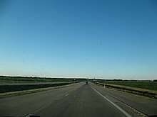
This western section of US 24 is mostly rural two-lane. US 24 enters Indiana from Illinois concurrent with U.S. Route 52 (US 52). US 24 and US 52 heads east towards Kentland, passing through an intersection with State Road 71 (SR 71). In Kentland US 24 and US 52 have an intersection with U.S. Route 41 (US 41) where US 52 turns south. US 24 heads east from Kentland towards Remington, passing through a concurrency with State Road 55. Then in Remington US 24 starts a concurrency with U.S. Route 231. US 24 and US 231 heads east towards Wolcott, passing through an interchange with Interstate 65 (I-65). In Wolcott US 231 heads south and US 24 heads east towards Reynolds. In Reynolds US 24 has an intersection with State Road 43 (SR 43) and starts a concurrency with U.S. Route 421 (US 421). US 24 and US 421 heads east towards Monticello. In Monticello US 421 head south with State Road 39 (SR 39), US 24 now has a concurrency with SR 39. US 24 and SR 39 heads east from Monticello, east of Monticello SR 39 heads north. US 24 heads east towards Logansport, passing through Idaville, Burnettsville, and Lake Cicott.[2]
Logansport to Fort Wayne
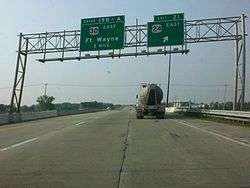
This section is a four-lane rural divided highway. US 24 and U.S. Route 35 (US 35) have a concurrency around Logansport and have an interchange with State Road 25 (SR 25) and an intersection with State Road 29 (SR 29). East of Logansport US 35 heads southeast towards Kokomo. US 24 heads east towards Peru passing through an interchange with U.S. Route 31 (US 31). On the north side of Peru US 24 has an intersection with State Road 19 (SR 19). From Peru US 24 heads east towards Wabash passing through an intersection with State Road 115 (SR 115). In Wabash US 24 has intersections with State Road 15 (SR 15) and State Road 13 (SR 13). US 24 then heads towards Huntington passing through an intersection with State Road 524 (SR 524) and a short concurrency with State Road 105 (SR 105). On the west side of Huntington US 24 begins a concurrency with State Road 9 (SR 9). US 24 and SR 9 pass through an intersection with U.S. Route 224 (US 224)/State Road 5 (SR 5). North of Huntington SR 9 heads north and US 24 heads northeast towards Fort Wayne. On the way to Fort Wayne US 24 passes through an intersection with State Road 114 (SR 114). Then on the west side of Fort Wayne US 24 enters onto northbound Interstate 69 (I-69).[3]
Fort Wayne to Ohio
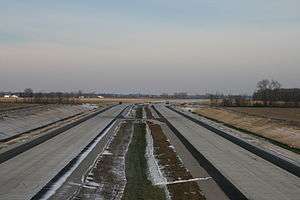
This section of US 24 is mostly freeway, and includes overlaps with Interstate Highways. US 24 enters I-69 heading north at exit 302 (formerly exit 102). US 24 then leaves I-69 at exit 315 (formerly exit 115. US 24 heads east on Interstate 469 (I-469). US 24 is concurrent with I-469 until the east side of New Haven, passing through interchanges with Maplecrest Read and SR 37. US 24 exits I-469 at exit 21 and heads northeast toward Ohio, on a four-lane rural freeway. The highway has an interchange with Webster Road in rural Allen County. After the interchange at Woodburn Road is an interchange with SR 101 in Woodburn. After the interchange with SR 101, US 24 enters Ohio.[4]
History
Logansport to Fort Wayne
In Logansport US 24 went through Logansport. The first route of US 24 was two-lane undivided rural highway north of the new four-lane highway from Logansport to Peru and south of the four-lane highway from Peru to Huntington. From Huntington to Fort Wayne the four-lane highway was built over the two-lane highway.
Fort Wayne to New Haven
Before US 24 was rerouted onto I-69 and I-469, US 24 went through Fort Wayne. US 24 went through downtown on one-way streets. Then east of Fort Wayne US 24 has an interchange with US 30 and then a concurrency with US 30, now known as SR 930. Then US 24 headed downtown New Haven, with US 30 bypassing downtown New Haven. Then US 24 headed north out of downtown New Haven and then turned east. In the early 1980s, US 24 was rerouted out of downtown Fort Wayne, following I-69 north to US 30/Coliseum Boulevard (now SR 930), and then following Coliseum Boulevard around the northern edge of the city. When the southern loop of I-469 opened to traffic in 1989, US 24 was rerouted onto I-69 south, then I-469 to the current interchange with US 24 east of New Haven. After the original 2-lane alignment was bypassed by a 4-lane freeway east of I-469 in 2012, US 24 was rerouted to its present alignment using the northern loop of I-469, via I-69 north.
Fort to Port
2008–12 upgrades
Fort to Port was first brought up in a meeting by Indiana State Representative Mitch Harper, in 1989. The project went from New Haven, Indiana to Toledo, Ohio. It was at this meeting the project name "Fort to Port" was born. The most complex and expensive portion of the Indiana segment was to be reconstructing the parclo interchange with Interstate 469 in New Haven.
In November 2007, Indiana announced they would reduce costs by changing their segment to be an expressway with at-grade intersections at Bruick Road, Webster Road, and SR 101, instead of a freeway section with interchanges and overpasses. The only overpasses would be two narrow (12' wide) overpasses for non-motorized traffic (Amish buggies) to cross US 24. Also, the interchange of I-469 and US 24 would remain as-is with traffic signals at the US 24 ramp terminals. The cost savings without interchanges would be approximately $75–$80 million. Right of way would be purchased for future interchanges. This change has been unpopular due to safety concerns with the heavy truck traffic on the corridor. INDOT claims that the current traffic on US 24 does not justify interchanges, even though the 2005 Final EIS states that it does.
Responding to widespread public outcry over the scaled-back design, Governor Mitch Daniels announced on December 12, 2007, that US 24 would have been built as a freeway initially from Bruick Road to the Ohio state line, with interchanges at SR 101 and Webster Road.[5] The intersection with Bruick Road was to have initially been an at-grade crossing, but INDOT announced in August 2009 that a grade-separated interchange was to be built here as well.[6] Indiana's entire 13.5-mile (21.7 km) segment of US 24 was completed as a freeway. The interchange with I-469, however, was unchanged and remained at-grade.
Upon completion, ownership of the existing US 24 was be transferred to Allen County, and become a frontage road east of Bruick Road, providing access to the B.F. Goodrich tire plant and adjacent homes and farmland. Indiana is financing construction through the Major Moves program, and will be reimbursed when federal highway funds become available. Sections of the two-lane road that have been bypassed by the freeway are now locally signed as "Old US 24."
Governor Daniels and INDOT held the groundbreaking ceremony for the Indiana section on April 30, 2008. By December 2008, crews had completed construction on 2 miles (3.2 km) of the freeway from the Ohio state line to just east of the SR 101 interchange. On October 29, 2009, Governor Daniels and Ohio Governor Ted Strickland held a ribbon-cutting ceremony at the Indiana/Ohio state line opening the new US 24 highway from SR 101 near Woodburn, Indiana to Ohio State Route 424 near Defiance, Ohio.[7] The project was designated completed and the final segment opened on November 4, 2012.[8]
Interchange with I-469
In the original plans, INDOT intended to upgrade the I-469/US 24 interchange to allow free-flowing movements between the two highways as documented in the Fort-to-Port Final Environmental Impact Statement published in 2005. This included building a 2,200-foot (670 m) flyover ramp from eastbound US 24 to southbound I-469. Five years later, no work had been performed on this interchange.
In May 2017, it was announced that a modification to the original plan was in process. The long proposed flyover was being replaced with two significantly shorter bridges. Furthermore, the interchange was going to be upgraded in two phases. The initial phase will eliminate the traffic signal and would entail everything but the modified flyover, in particular both northbound I-469 to westbound US 24 and eastbound US 24 to northbound I-469 would be converted to free-flowing movements. This first phase should be completed in 2019. The remaining free-flowing connection would be completed at a later date.[9]
Major intersections
| County | Location | mi[1] | km | Exit | Destinations | Notes |
|---|---|---|---|---|---|---|
| Newton | Jefferson Township | 0.000 | 0.000 | Continuation into Illinois | ||
| 1.815 | 2.921 | Northern terminus of SR 71 | ||||
| Kentland | 4.616 | 7.429 | Eastern end of US 52 concurrency | |||
| Goodland | 10.566 | 17.004 | Western end of SR 55 concurrency | |||
| 11.065 | 17.807 | Eastern end of SR 55 concurrecny | ||||
| Jasper | Remington | 19.537 | 31.442 | Western end of US 231 concurrency | ||
| 21.236– 21.405 | 34.176– 34.448 | |||||
| White | Wolcott | 26.270 | 42.277 | Eastern end of US 231 concurrency | ||
| Reynolds | 35.098 | 56.485 | Western end of US 421 concurrency; northern terminus of SR 43 | |||
| Monticello | 41.012 | 66.002 | Eastern end of US 421 concurrency; western end of SR 39 concurrency | |||
| Union Township | 42.276 | 68.037 | Eastern end of SR 39 concurrency | |||
| Cass | Logansport | 60.840 | 97.912 | Western end of US 35 concurrency; western end of Bus. US 24 | ||
| 62.182 | 100.072 | — | Old State Road 25 | Interchange | ||
| 62.982 | 101.360 | Split diamond interchange, together with interchange for SR 25 north; western end of SR 25 concurrency; northern terminus of SR 29 | ||||
| 63.257 | 101.802 | — | Split diamond interchange, together with interchange for SR 25 south; eastern end of SR 25 concurrency; northern terminus of SR 329 | |||
| 67.171 | 108.101 | Eastern end of US 35 concurrency | ||||
| Miami Township | 74.444 | 119.806 | Eastern end of Bus. US 24 | |||
| Miami | Peru Township | 77.451 | 124.645 | — | ||
| Peru | 81.218 | 130.708 | ||||
| Wabash | Noble Township | 92.028 | 148.105 | Southern terminus of SR 115 | ||
| Wabash | 94.018 | 151.307 | ||||
| 96.464 | 155.244 | |||||
| Lagro | 98.553 | 158.606 | Western terminus of SR 524 | |||
| Huntington | Dallas Township | 106.531 | 171.445 | Western end of SR 105 concurrency | ||
| Andrews | 107.659 | 173.260 | Eastern end of SR 105 concurrency | |||
| Huntington | 111.700 | 179.764 | Southern end of SR 9 concurrency | |||
| 113.525 | 182.701 | Western terminus of US 224 | ||||
| Huntington Township | 115.239 | 185.459 | — | Northern end of SR 9 concurrency | ||
| 116.424 | 187.366 | — | Old US 24 | Westbound exit and eastbound entrance | ||
| Huntington–Whitley county line | Jackson–Jefferson township line | 126.817 | 204.092 | Eastern terminus of SR 114 | ||
| Allen | Fort Wayne | 131.151– 132.316 | 211.067– 212.942 | Western end of I-69 / US 33 concurrency | ||
| 135.553 | 218.151 | 305 | Signed as exits 305A (east) and 305B (west) | |||
| 139.509 | 224.518 | 309 | Eastern end of US 33 concurrency; western end of US 30 concurrency; signed as exits 309A (east) and 309B (west / north); western end of SR 930 | |||
| 141.290 | 227.384 | 311 | Signed as exits 311A (south) and 311B (north) | |||
| 142.592 | 229.480 | 312 | Coldwater Road | Signed as exits 312A (south) and 312B (north) | ||
| 145.335 | 233.894 | 315 31 | Auburn Road | Eastern end of I-69 concurrency; west end of I-469 concurrency; westbound exit only to Auburn Road; exit 315 on I-69 and exit 31 on I-469 | ||
| St. Joseph Township | 147.590 | 237.523 | 29 | Maplecrest Road | Signed as exits 29A (north) and 29B (south) eastbound | |
| Fort Wayne | 151.582 | 243.948 | 25 | Southern end of the northern segment of SR 37 | ||
| Jefferson Township | 155.283 | 249.904 | Eastern end of I-469 / US 30 concurrency | |||
| Milan Township | 157.348 | 253.227 | — | Bruick Road | Interchange | |
| 158.472 | 255.036 | — | Webster Road | Interchange | ||
| Maumee Township | 164.239 | 264.317 | — | Interchange | ||
| 166.846 | 268.513 | Continuation into Ohio | ||||
1.000 mi = 1.609 km; 1.000 km = 0.621 mi
| ||||||
See also

References
- 1 2 Indiana Department of Transportation (July 2016). Reference Post Book (PDF). Indianapolis: Indiana Department of Transportation. US 24, I 69, I 469. Retrieved September 23, 2017.
- ↑ Google (April 22, 2011). "Overview Map of the Western Segment of US 24" (Map). Google Maps. Google. Retrieved April 22, 2011.
- ↑ Google (April 22, 2011). "Overview Map of the Middle Segment of US 24" (Map). Google Maps. Google. Retrieved April 22, 2011.
- ↑ Google (November 19, 2013). "Overview Map of the Eastern Segment of US 24" (Map). Google Maps. Google. Retrieved November 19, 2013.
- ↑ Indiana Department of Transportation (December 12, 2007). "Interchanges to Be Built on Fort to Port Project" (Press release). Indiana Department of Transportation. Archived from the original on December 22, 2007.
- ↑ Indiana Department of Transportation (August 7, 2009). "US 24 Proposed Pedestrian Bridge Upgraded to Interchange and Design Work Pending for SR 14 Adjacent to Inverness Pond" (Press release). Indiana Department of Transportation. Archived from the original on September 24, 2015.
- ↑ Sade, Vivian (November 15, 2012). "Fort to Port finally open for business". The Journal Gazette. Fort Wayne. OCLC 7368210. Retrieved November 15, 2012.
- ↑ Indiana Department of Transportation. "US 24 Fort to Port". Indiana Department of Transportation. Retrieved May 11, 2017.
- ↑ Clark, Rickie (May 10, 2017). "I-469 at US 24 Interchange Modification" (PDF). Indiana Department of Transportation.
External links
Route map:
| Previous state: Illinois |
Indiana | Next state: Ohio |