List of unused highways in Ohio
An unused highway may reference a highway or highway ramp that was partially or fully constructed but was unused[1][2][3][4][5][6][7][8][9] or later closed.[10][11][12] An unused ramp can be referred to as a stub ramp,[13] stub street,[2][14][15] stub-out,[2] or simply stub.[16][17] The following is a list:
List
Alliance
- The bypass around Alliance, which has a hidden designation of US-62T (formerly US-62F), ends at State Route 225, and there are stubs of where the freeway would continue eastward. As of 2007, the project to build the continuation is in the early stages of study.[18][19]
Canton
- In Stark County, between Canton and East Canton, the U.S. Route 30 freeway ends at an interchange at Trump Avenue, which US 30 follows north to its former alignment along State Route 172. A stub exists where the westbound US 30 freeway will meet the westbound onramp.[20] The freeway is planned to be extended eastward to State Route 44, and had been planned to extend further to State Route 11.[21]
Chesapeake
- For two decades, State Route 7's partially completed bypass around Chesapeake has had a partial trumpet intersection for a future eastward extension to the Proctorville bypass. The Chesapeake Bypass project[22] is still active, although it no longer has any funding.[23]
Cincinnati
- The interchange of Interstate 74 and Beekman Street in Cincinnati was supposed to have been the interchange for the Colerain Expressway, which was never constructed. Stub ramps existed on both directions of Beekman and the westbound I-74 on-ramp until a 2012 reconstruction . Grading is still visible. In 2012 reconfiguring was done at the intersection of Beekman and Colerain, and on the ramp to I-74 in 2014.[24]
- Downtown, there is a stub ramp on Interstate 71 southbound at its interchange with Interstate 75. It used to be the connector ramp from southbound I-71 to northbound I-75.[25] The replacement ramp is now a left exit. The stub points north, whereas the ramp to merge with southbound I-75 turns south.Stub old configuration
- Stub ramps exist on Interstate 71 near Victory Parkway, where an interchange with the road was once planned. Attempts at building an interchange in this location have been repeatedly opposed.[26] Additionally, the ramp from Montgomery Road to I-71 south was built extraordinarily long in order to allow room for the Victory Parkway interchange without traffic weaving.[27]
Cleveland
- Original plans for the Cleveland highway network included the Parma Freeway, a limited-access freeway linking the Cleveland Memorial Shoreway to the suburb of Parma with major interchanges at the Clark Freeway (Interstate 90/Interstate 290), the Medina Freeway (Interstate 71), and the Outerbelt (Interstate 480).[28] Along with many other local highways, it was cancelled during the freeway revolts in the 1960s. However, a small portion of the Parma Freeway exists today as access ramps between Denison Avenue and I-71, with an unused portion of the freeway adjacent to the onramp. 41°27′11″N 81°43′48″W / 41.453°N 81.73°W
- Abandoned ramp segments exist on the north side of the Interstate 90/Interstate 77 interchange, remnants of the original configuration of the I-90/I-77 interchange and associated ramps prior to the Innerbelt Bridge project in the 2010s. 41°29′42″N 81°40′48″W / 41.495°N 81.68°W
Columbia
- There is a short road near the western end of the Ohio Turnpike in Columbia, slightly more than a half-mile (0.8 km) east of the Indiana state line, connecting the turnpike to US 20. From October 1, 1955[29] until August 16, 1956, the day before the Indiana Toll Road was completed to the state line, the road functioned as a stub ramp to US 20.[30] It then served as an access road to the original location of the turnpike's Westgate toll barrier,[31] before the barrier was relocated farther east on December 29, 1992.[32][33] (A similar access road now connects US 20 and the current Westgate.) The road is now closed to the public and is used as a storage area for Jersey barriers.
Columbus
- The State Route 315 and Bethel Road interchange has a missing loop ramp in the northwest quadrant, and the ramp from State Route 315 southbound only curves to the right at the very end, as if a left turn movement should be available. Bethel Road ends at State Route 315, although an extension east to Morse Road has been in the plans for decades. However, there has been much opposition from local residents.[34]
Dayton
- Where Interstate 75 meets Riverside Drive near Dayton, a semi-directional interchange to and from I-75 north used to exist. While the southwest quadrant cloverleaf is still in use, grading is still evident for the northwest cloverleaf and the southeast ramp. Evidence for the northeast ramp has been mostly if not completely removed.
- Where U.S. Route 35 meets Research Boulevard there is an exit ramp from US 35 eastbound and an entrance ramp to U.S. 35 westbound. While the exit ramp is still in use, the entrance ramp is no longer in use and is blocked off. This is a remnant of a merge/split between U.S. 35 and State Route 835 which was partially replaced by the North Fairfield Road interchange. The exit ramp also connects to the local road network via Patterson Road. Map showing it operational
Kirkersville
- Before Interstate 70 was completed to Columbus, it was temporarily redirected back to U.S. Route 40. When I-70 was completed, this old transfer segment was partially closed. Half of it is now used for State Route 158 to bypass the town of Kirkersville. A single overpass and the crumbling remains of the westbound lanes reveal its original status as an Interstate. It can be viewed on online maps.
Mahoning County
- There was a rest area on State Route 11 approximately four miles from the Columbiana County border that was closed for reconstruction in 2008.[35] Subsequently, the rest area has been removed from the Ohio Rest Area System.[36] Rest area buildings have been destroyed and the on ramps are covered with grass, however the off ramps and other concrete roadways remain.
Milford
- Three-quarters of a cloverleaf connecting the Milford Parkway with the outer loop Interstate 275 are operative. The southeastern segment, which previously led from the eastbound lane of what is now called State Route 450 to northbound I-275, was removed when the stub interchange was rebuilt into SR 450, also known as the Milford Parkway. A small segment of pavement and grading confirm the fourth leaf's former existence. The northeastern quadrant was rebuilt during this time as well, changing the angle of the turn for traffic exiting the interstate to be less acute, and creating a three-way intersection rather than an westbound-only merge. The entrance ramp from the northeast onto I-275, which now requires a left-hand turn from eastbound SR 450, replaced the southeastern segment of the cloverleaf. Prior to being rebuilt, the road used to end approximately 1 mile west of I-275, so the southeastern section saw very little use. State Route 450 was established on November 22, 2004 along a formerly unsigned highway that had been given an internal designation of U.S. Route 50T by the Ohio Department of Transportation.[37]
Morristown
- West of Morristown town at mile marker 204 at the I-70/US-40 interchange lays a partially submerged abandoned section of what was US-40 before I-70 was built over top of it. It is located on the north side of I-70 just west of the intersection of McMillan Rd. from the south, Egypt North Rd. from the north and US-40 from the east. It is currently being used as construction storage for the rebuilding of the west bound entrance ramp and bridge refurbishment.
Nelsonville
- U.S. Route 33 was rerouted north of Nelsonville as a bypass that opened October 1, 2013.[38] The former western (at 39°28′41″N 82°18′55″W / 39.478018°N 82.315246°W) and eastern (at 39°25′52″N 82°11′52″W / 39.431221°N 82.197808°W) approaches to and from Nelsonville have been blocked off, with the western entrance to the city now including a roundabout.[39]
Norwalk
- Where the U.S. Route 20 freeway ends at its older alignment east of Norwalk, stubs exist at the ends of the ramps, implying a northward extension.[40]
Piketon
- Along U.S. Route 23 south of Piketon, there are remnants of an old diamond interchange with State Route 32, before State Route 32 was reconstructed as a four-lane highway and a new interchange built. Current interchange and abandoned ramps
Richfield
- The original interchange between the Ohio Turnpike and Ohio State Route 21 (formerly U.S. Route 21) was a trumpet-T. After Interstate 77 was built near Richfield, the interchange was rebuilt as a double trumpet to accommodate increased traffic. The interchange was rebuilt as a direct connection with I-77 in 2001, a folded diamond was built in the middle to connect to SR 21. Meanwhile, the old connector ramp and toll booth still stand.
Swanton

An abandoned portion of US Route 20A at the Toledo Express Airport
- North of the Toledo Express Airport, an abandoned segment of US 20A branches off SR 2 (Airport Highway), which is currently used to test pavement markings. On a map of the county from 1898, and a map of the state from 1945, the intersection is clearly visible, along with the former routing of SR 295.[41][42]
Toledo
- Just north of where Interstate 75 meets the Anthony Wayne Trail (State Route 25) near Toledo, a short ramp stub joins onto I-75 northbound. This was apparently planned to connect to a cancelled freeway named the Downtown Distributor that would have run from the current Anthony Wayne Trail terminus through downtown, along the banks of the Maumee River. Note that when the trail ends just east of I-75, the northbound lanes curve sharply to the right of the planned alignment; it is not clear if grading still remains. (The trail has ended that way since the end was moved from Erie Street in the 1950s. On a county map from 1973,[43] those ramps were to have begun a freeway marked as State Route 112. It was planned to run to the Maumee River, through the historic St. Patrick's Catholic Church. This is why neither ODOT nor the city has built it. It would have ended at the Summit Street interchange on Interstate 280, and would have had a spur providing a freeway connection to the Anthony Wayne Bridge.[44][45][46]
Whitehouse
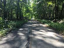
An abandoned section of Reed road at Oak Openings Preserve Metropark.
- In Oak Openings Preserve Metropark, an abandoned segment of Reed Road branches off its current alignment, which becomes Oak Openings Parkway where the abandoned road begins. According to an 1898 map, the road continues straight through what is now Oak Openings, with properties of the Reed family along the road. Wilkins Road, where Reed Road continues along its original alignment to the east, was also converted to a bike trail between the parkway and SR 64.[47] Much of the abandoned road is still paved, and is used by bikes and pedestrians.
Youngstown
- There is a disconnected roadway along U.S. Route 62 westbound/State Route 7 southbound at the U.S. Route 422 interchange near Youngstown. This was likely intended to be a collector/distributor road, but is unused because the US 62/State Route 7 freeway was not completed to the northeast, though an extension is planned to run to Interstate 80.[18][19][48]
- There was an unused bridge over State Route 11 which was intended to be used for the never constructed expansion to Lanterman Rd.[49] This bridge was demolished in September 2013 to help make way for the Hollywood Racino.
Zanesville
- Abandoned entrance ramp stub from Underwood St. on the west bound lane at mile marker 155. The entrance ramp is now at the western terminus of Elm St. which runs on the north side of I-70 mainline.
See also
References
- ↑ "US&R and NY-TF1 Practice for the Real Thing." City of New York 20 June 2005. 15 Jan. 2007 "Archived copy". Archived from the original on 2006-10-14. Retrieved 2012-03-19. .
- 1 2 3 "Kentucky Model Access Management Ordinance." Kentucky Transportation Cabinet Oct. 2004. 15 Jan. 2007 "Archived copy" (PDF). Archived from the original (PDF) on 2006-09-26. Retrieved 2007-01-15. .
- ↑ "Barrie (City) v. 1606533 Ontario Inc.", 2005 CanLII 24746 (ON S.C.). 15 Jan. 2007 .
- ↑ Iowa House. 1998. House File 686., 77th, H.R. 0686. .
- ↑ "PETITIONED PUBLIC HEALTH ASSESSMENT." New York City. 15 Jan. 2007 .
- ↑ House. 1993. LAND TITLE AMENDMENT ACT, 1993. 35th Parliament, 2nd sess., H.R. 78. .
- ↑ Munroe, Tapan. "TRENDS ANALYSIS for PARKS & RECREATION: 2000 AND BEYOND." California Park & Recreation Society Jan. 1999. 15 Jan. 2007 "Archived copy" (PDF). Archived from the original (PDF) on 2006-10-09. Retrieved 2007-01-15.
- ↑ "Chapter 5: Detailed Comparison of Alternatives – Seattle." SR 520 Bridge Replacement and HOV Project, Washington Department of Transportation, 2 May. 2005. 15 Jan. 2007 "Archived copy" (PDF). Archived from the original (PDF) on 2007-10-09. Retrieved 2007-01-15. .
- ↑ Anderson, Steve. "CT 11 Expressway." New York City Roads. 15 Jan. 2007 .
- ↑ "Leasing of Closed Highways Regulation", Alta. Reg. 36/1986. 15 Jan. 2007 "Archived copy". Archived from the original on 2007-09-29. Retrieved 2007-11-22. .
- ↑ "R. v. Sanders", 2004 NBPC 12 (CanLII). 15 Jan. 2007 .
- ↑ "HIGHWAY CLOSINGS", R.R.O. 1990, Reg. 599. 15 Jan. 2007 "Archived copy". Archived from the original on 2007-09-29. Retrieved 2007-11-24. .
- ↑ "Washington State Department of Transportation Public Transportation and Rail Division Monthly News, October 2006, page 4" (PDF). Archived from the original (PDF) on 2006-10-08. (286 KiB), accessed December 28, 2006
- ↑ Sommer, Dick. "Ten Ways to Manage Roadway Access in Your Community." Ohio Department of Transportation, 2005. 15 Jan. 2007 .
- ↑ Bauserman, Christian E. "DELAWARE COUNTY ENGINEER’S DESIGN, CONSTRUCTION & SURVEYING STANDARDS." 18 May 1998. 15 Jan. 2007 .
- ↑ Geiger, Gene. "Ohio DOT Constructs I-670 over a Water Treatment Sludge Lagoon in Columbus." Ohio LTAP Quarterly. Ohio Department of Transportation. 15:3 (1999) .
- ↑ "CITY OF UNION, KENTUCKY." City of Union, Kentucky 23 June 2006. 15 Jan. 2007 "Archived copy". Archived from the original on 2007-09-27. Retrieved 2012-03-19. .
- 1 2 "T.R.A.C. Projects". ODOT. Archived from the original on 2007-07-19.
- 1 2 "Archived copy" (PDF). Archived from the original (PDF) on 2007-09-28. Retrieved 2007-11-24.
- ↑ 40°47′00″N 81°19′06″W / 40.783357°N 81.318232°W
- ↑ "US 30 Information Site". ODOT. Archived from the original on 2007-08-09.
- ↑ "Chesapeake Bypass". Ohio Department of Transportation.
- ↑ "Earmarks". whitehouse.gov. Archived from the original on 2008-10-30.
- ↑ Mecklenborg, Jake. "Never-Built Cincinnati Expressways". cincinnati-transit.net.
- ↑ "Cincinnati, ca 1999". TerraServer. Archived from the original on 2011-05-18.
- ↑ Mecklenborg, Jake. "Interstate 71".
- ↑
- ↑ Cuyahoga County, Ohio (March 1966). "Route Location Studies: Parma Freeway, State Road to Clark Avenue (Report Number 12)". Howard, Needles, Tammen & Bergendoff. Retrieved 2018-05-16.
- ↑ Staff. "Chapter 3: Giant Strides, 1946–1964". The First 60 Years, A History of Service. Ohio State Highway Patrol. Archived from the original on March 2, 2008. Retrieved July 10, 2007.
- ↑ "Exit on Ohio Turnpike Closed". The Pittsburgh Press. August 16, 1956. p. 7. Retrieved August 27, 2012.
- ↑ Clear Lake, Ind.–Ohio–Mich (Map). 1:24,000. 7.5 minute (Topographic). U.S. Geological Survey. 1990. Archived from the original (PDF) on April 8, 2013. Retrieved August 27, 2012.
- ↑ Herb Lewis (December 30, 1992). "Turnpike exchange near Edon is officially opened". The Bryan Times. Retrieved August 26, 2012.
- ↑ Hank Harvey (February 28, 1993). "Turnpike Commission may branch out". The Blade. Toledo, OH. Retrieved August 26, 2012.
- ↑ "Morse-Bethel Connector". Clintonville Area Commission. Archived from the original on October 9, 2007.
- ↑ "Mahoning County Weekly Traffic Advisory". Ohio Department of Transportation. 09-05-2008. Retrieved 09-10-2013. Check date values in:
|accessdate=, |date=(help) - ↑ "Ohio's Rest Area System". Ohio Department of Transportation. Retrieved 09-10-2013. Check date values in:
|accessdate=(help) - ↑ Ohio Department of Transportation. "Technical Services Straight Line Diagrams: US Route 50T" (PDF). Archived from the original (PDF) on September 27, 2004. Retrieved 2013-12-31.
- ↑ Lane, Mary Beth (October 2, 2013). "Rt. 33 motorists save time as Nelsonville bypass opens". The Columbus Dispatch. Retrieved May 12, 2014.
- ↑ DeWitt, David (September 23, 2012). "Part of Nelsonville highway bypass comes online". The Athens News. Retrieved May 12, 2014.
- ↑ "Sandusky Photos". Roadfan.com. 31 August 2004. Retrieved 4 December 2014.
The eastern end of the bypass around Norwalk (which carries US 20 its whole length and Ohio 18 from the western end to the last exit before the eastern end -- see the exit guide) is built to facilitate a northward extension. Note the right-of-way for a possible eastbound (northbound) roadway in the center of the picture (it ends at the right-of-way for Cleveland Road/old US 20).
- ↑ "Map of Lucas County, Ohio". Blue Oil Map Co. The former portions of SR 295 are currently used as servis roads for the airport. Retrieved 08-01-2018. Check date values in:
|accessdate=(help) - ↑ "Ohio Highway Map" (PDF). Ohio Department of Highways. Retrieved 08-02-2018. Check date values in:
|accessdate=(help) - ↑ Lucas County Engineer County Map, 1973
- ↑ "Interstate 475 opens through West Toledo – Toledo History Box". www.toledohistorybox.com. Retrieved 2018-07-14.
- ↑ "Toledo Expressway System Engineering Feasibility Report" (PDF). Retrieved 2018-07-14.
- ↑ "Toledo Expressway System Engineering Feasibility Report" (PDF). Retrieved 2018-07-14.
- ↑ "Map of Lucas County, Ohio". Blue Oil Map Co. Retrieved 08-01-2018. Check date values in:
|accessdate=(help) - ↑ "Archived copy" (PDF). Archived from the original (PDF) on 2007-02-21. Retrieved 2007-11-24.
- ↑ "Officials clear final hurdle for Austintown racino". The Vindicator.
This article is issued from
Wikipedia.
The text is licensed under Creative Commons - Attribution - Sharealike.
Additional terms may apply for the media files.