Springfield Township, Gallia County, Ohio
| Springfield Township, Gallia County, Ohio | |
|---|---|
| Township | |
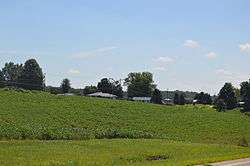 Along State Route 160 northwest of Kerr | |
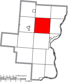 Location of Springfield Township in Gallia County | |
| Coordinates: 38°53′52″N 82°16′43″W / 38.89778°N 82.27861°WCoordinates: 38°53′52″N 82°16′43″W / 38.89778°N 82.27861°W | |
| Country | United States |
| State | Ohio |
| County | Gallia |
| Area | |
| • Total | 36.9 sq mi (95.5 km2) |
| • Land | 36.7 sq mi (95.1 km2) |
| • Water | 0.2 sq mi (0.4 km2) |
| Elevation[1] | 692 ft (211 m) |
| Population (2010) | |
| • Total | 3,664 |
| • Density | 100/sq mi (38.5/km2) |
| Time zone | UTC-5 (Eastern (EST)) |
| • Summer (DST) | UTC-4 (EDT) |
| FIPS code | 39-74120[2] |
| GNIS feature ID | 1086145[1] |
Springfield Township is one of the fifteen townships of Gallia County, Ohio, United States. As of the 2010 census the population was 3,664,[3] up from 3,181 at the 2000 census.[4]
Geography
Located in the northern part of the county, it borders the following townships:
- Morgan Township - north
- Cheshire Township - northeast corner
- Addison Township - east
- Gallipolis Township - southeast corner
- Green Township - south
- Perry Township - southwest corner
- Raccoon Township - west
- Huntington Township - northwest corner
Springfield Township is one of only two county townships without a border on another county.
No municipalities are located in Springfield Township, although the unincorporated communities of Bidwell and Kerr are located near the center of the township.
Name and history
It is one of eleven Springfield Townships statewide.[5]
Government
The township is governed by a three-member board of trustees, who are elected in November of odd-numbered years to a four-year term beginning on the following January 1. Two are elected in the year after the presidential election and one is elected in the year before it. There is also an elected township fiscal officer,[6] who serves a four-year term beginning on April 1 of the year after the election, which is held in November of the year before the presidential election. Vacancies in the fiscal officership or on the board of trustees are filled by the remaining trustees.
References
- 1 2 "US Board on Geographic Names". United States Geological Survey. 2007-10-25. Retrieved 2008-01-31.
- ↑ "American FactFinder". United States Census Bureau. Retrieved 2008-01-31.
- ↑ "Geographic Identifiers: 2010 Demographic Profile Data (G001): Springfield township, Gallia County, Ohio". American Factfinder. U.S. Census Bureau. Retrieved January 12, 2017.
- ↑ Gallia County, Ohio — Population by Places Estimates Ohio State University, 2007. Accessed 15 May 2007.
- ↑ "Detailed map of Ohio" (PDF). United States Census Bureau. 2000. Retrieved 2007-02-16.
- ↑ §503.24, §505.01, and §507.01 of the Ohio Revised Code. Accessed 4/30/2009.
External links
Municipalities and communities of Gallia County, Ohio, United States | ||
|---|---|---|
| Villages | 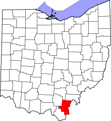 | |
| Townships | ||
| CDP | ||
| Unincorporated communities | ||