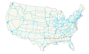
U.S. Route 80
| |
|---|---|
 | |
| Route information | |
| Length | 1,032.28 mi (1,661.29 km) |
| Existed | 1926[1]–present |
| Major junctions | |
| West end |
|
|
| |
| East end |
|
| Location | |
| States | Texas, Louisiana, Mississippi, Alabama, Georgia |
| Highway system | |

U.S. Route 80 (US 80) is an east–west United States Numbered Highway, much of which was once part of the early auto trail known as the Dixie Overland Highway. As the "0" in the route number indicates, it was originally a cross-country route, from the Pacific Ocean to the Atlantic Ocean. However, the entire segment west of Dallas, Texas, has been decommissioned in favor of various Interstate Highways and state highways. Currently, the highway's western terminus is at an interchange with Interstate 30 (I-30) on the Dallas–Mesquite, Texas city line. The highway's eastern terminus is in Tybee Island, Georgia, at the intersection of Butler Avenue, Inlet Avenue, and Tybrisa Street, near the Atlantic Ocean.[2]
Route description
| mi[3] | km | |
|---|---|---|
| TX | 161 | 259 |
| LA | 199 | 320 |
| MS | 157 | 253 |
| AL | 218 | 351 |
| GA | 300 | 483 |
| Total | 1,035 | 1,666 |
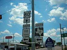
Texas
Modern US 80 begins as a significant component of the urban freeway system of Dallas, Texas. With Spur 557, it serves as the shortest freeway route from the central and northern portions of Dallas to I-20, heading east towards Shreveport, Louisiana.
From its origin at I-30 in eastern Dallas, through its interchange with the I-635 "LBJ" Loop, to its junction with I-20 southwest of Terrell, US 80/Spur 557 is a full Interstate-grade, limited-access freeway. (This freeway was originally built as I-20 but was rerouted south of Dallas in 1971 and 1991.) In western Terrell, US 80 leaves the freeway, which continues southeast as (unsigned) Spur 557 to I-20, while US 80 runs north of I-20 through a number of small towns and cities, including Terrell, Mineola, Longview, and Marshall. It rejoins I-20 for about five miles (8.0 km), before splitting to pass through downtown Waskom before crossing into Louisiana.
Louisiana
US 80 is parallel to the newer I-20, which has supplanted it as a long-distance route, for the entirety of its length in Louisiana.
The highway crosses the state line from Texas into Caddo Parish as a two-lane road and crosses over to the south of I-20 without connecting with the freeway. It passes through the town of Greenwood where it meets US 79 coming north from Texas, and these two routes run concurrently eastward from there to Minden. US 79/US 80 crosses over I-20 again, this time at an interchange, and enters the city of Shreveport as Greenwood Road. The highway passes over I-220 without an interchange and continues east to an intersection with Jefferson Paige Road where it expands to four undivided lanes and enters the main part of the urbanized area. US 171 ends at US 79/US 80 at the intersection with Hearne Avenue. At this intersection, the road narrows to two through lanes. US 80 intersects I-20 again just east of here. At Mansfield Road (old US 171), the highway name changes to Texas Avenue and angles northeast through an industrial area. The road skirts the I-20/I-49 interchange and expands to four lanes for its final approach to downtown. At the west edge of downtown, eastbound jogs one block east on Crockett Street and two blocks north on Common Street north to Texas Street; westbound jogs one block south from Texas Street down Common to Texas Avenue. US 79/US 80 passes through downtown Shreveport on Texas Street before crossing the Red River on the 1930s vintage Long–Allen Bridge and entering Bossier City and Bossier Parish.
Through Bossier Parish, US 79/US 80 comprises a major urban and suburban arterial (East Texas Street) carrying a minimum of four lanes. In the eastern reaches of the parish, and continuing into Webster Parish, it is a divided highway. The road intersects the east end of I-220 at an interchange. US 79/US 80 stays to the north of I-20, except for a stretch east of Haughton where it strays to the south for a period, skirting the north edge of the Louisiana Army Ammunition Plant. At Dixie Inn, the highway intersects US 371. In Minden, US 79 separates from US 80 and continues its northeasterly trajectory toward Arkansas.
East of Minden, US 80 crosses to the south of I-20 and serves the Bienville Parish towns of Gibsland and Arcadia. Entering Lincoln Parish, the highway serves Simsboro and Grambling before entering Ruston (via West California Avenue) and overlapping US 167 on a north–south couplet of streets (Vienna Street/Trenton Street) through the business district. US 80 resumes its eastward path on the north side of Ruston and exits the city on East Georgia Avenue.
Between Ruston and Monroe the highway serves the small communities of Choudrant and Calhoun. Now on the north side of the interstate, it enters Ouachita Parish and approaches the Monroe area as a two-lane road. US 80 crosses Louisiana Highway 143 (LA 143) and enters West Monroe on Cypress Street, where it continues south into the business district and widens to a four-lane urban arterial. At junction LA 34 (Bridge Street), US 80 makes a left turn, angling northeast, and crosses the Ouachita River, entering the city of Monroe. As Louisville Avenue it passes north of downtown, but the downtown area can be accessed via Business US 165 which intersects US 80 at North 5th/North 6th Street and becomes concurrent from there to the east. Louisville Avenue rapidly becomes a heavily commercialized urban arterial and remains so as it passes through the city, eventually curving southwestward and meeting the intersection with Desiard Street.
As Desiard Street, US 80 immediately meets mainline US 165, on its expressway bypass alignment, at a diamond interchange. Eastward from there, US 80 passes through suburban areas until it meets LA 139, where it is forced to turn off its four-lane alignment at an intersection which favors LA 139 traffic. Now a two-lane road, US 80 continues east through northeast Louisiana, passing through Richland and Madison parishes and serving the communities and towns of Start, Rayville (intersection with US 425), Delhi (intersection with LA 17), Tallulah (intersection with U.S. Route 65), Mound, and Delta.
Just west of Delta, US 80 turns off its original route and runs a short distance south to an interchange with I-20. The original alignment of US 80 into Delta is now designated as LA 3218. The original US 80 Mississippi River Bridge remains active as a rail bridge but the roadway portion is closed to traffic. Today, US 80 runs concurrent with the interstate around Delta to the state line, bypassing the town and crossing the Mississippi River bridge into Vicksburg, Mississippi.
Mississippi
In Mississippi, US 80 is referred to as "Highway 80" and exists primarily as a two-lane road except in the Jackson area, where it expands to four lanes.
US 80 out of Louisiana runs concurrently with I-20 across the Mississippi River through Vicksburg, to Clinton. When US 80 reaches the western edge of Clinton, it separates to pass directly through the cities of Clinton, Jackson, Flowood, Pearl, and Brandon. After Brandon, US 80 runs parallel to I-20 for the next 100 miles (160 km) through the towns of Pelahatchie, Morton, Forest, Lake, Newton, Hickory, and Chunky. East of Chunky, US 80 once again merges with I-20 until it separates again in Meridian, where it merges with US 11 as a two-lane highway heading through the town of Toomsuba and finally ending at the Alabama state line.
Alabama
In Alabama, US 80 enters the state near and parallel with I-20 in Cuba. It is co-signed with US 11 until it splits at Cuba and runs east across the center of the state. It is a major highway through Alabama's Black Belt, going through Demopolis and Selma. It continues to Montgomery, where it continues east through Shorter and Tuskegee and leaves the state in Phenix City.
The routing from Meridian, Mississippi to Cuba, Alabama originally ran along its current route but for some 30 years it traveled along I-20 and I-59. However, the routing reverted to the original road early in the 2000s. It is internally designated by the Alabama Department of Transportation as State Route 8 (SR-8).
Georgia
US 80 crosses the Chattahoochee River from Alabama into Columbus, where it proceeds along J. R. Allen Parkway through the northern section of the city. Past Columbus, the road meanders through rural Georgia for roughly 50 miles (80 km) en route to Macon, where it crosses I-75 and I-16. US 80 passes through downtown Macon via Eisenhower Parkway and parallels the northern boundary of Ocmulgee National Monument just east of the city.
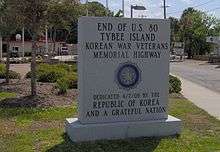
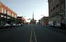
Beyond Macon, US 80 turns southeastward, passing through the cities of Dublin, Swainsboro and Statesboro and running roughly parallel to I-16. On the outskirts of Savannah, US 80 crosses I-95 and follows Louisville Road into the city's downtown area. After briefly merging with I-516, US 80 continues eastward along Victory Drive, just south of Savannah's historic district. At the community of Thunderbolt, US 80 crosses the Wilmington River and proceeds across the islands and marshes along the Atlantic Coast east of Savannah. There it crosses the Lazaretto Creek onto Tybee Island. The final stretch of US 80 follows Butler Avenue across Tybee Island. The highway terminates at 19th Street, a few hundred feet from the ocean. A small monument at the intersection of Butler and Tybrisa Street marks the end of the highway.
History
As an original US Highway commissioned in 1926, US 80 was advertised as the first all-weather coast-to-coast route available to auto travelers. Originally, US 80 had its western terminus in San Diego, California. Between 1964 and 1991, US 80 was slowly removed in increments between Dallas and San Diego, as the western states favored the new Interstate Highways in its place. As such, US 80 is no longer an active U.S. Highway in California, Arizona, New Mexico and western Texas.[4]
For a time known as the "Broadway of America", its history is second only to US 66 in American highway folklore, as several significant historical events have occurred on or near US 80.[5] Bonnie and Clyde were ambushed on LA 154, just south of US 80 near Gibsland, Louisiana.[6] Coincidentally, Clyde Barrow was buried with his brother just off former US 80 in Dallas.[7] Lee Harvey Oswald was captured at the Texas Theatre on Jefferson Street in Oak Cliff, which at the time was a business spur of US 80. As of 2018, the states of California, Arizona and Louisiana recognize former and current sections of US 80 as a historic foute.[8][9][10]
California
.svg.png)
US 80 originally had its western terminus in San Diego, California. It was gradually decommissioned between 1964 and 1974 as I-8, through San Diego and Imperial counties, was completed.
Arizona
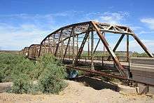
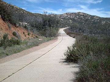
In Arizona, US 80 was routed through Yuma, Dateland, Gila Bend, Buckeye, Phoenix, Florence, Tucson, Benson, Tombstone, Bisbee and Douglas. Between 1977 and 1989, US 80 was removed from Arizona in favor of I-10 and I-8.[4] In Tucson there are over 281 extant historic motels and structures along the original US 80 alignment, especially on the Miracle Mile and Benson Highway segments. Part of former US 80 through Tucson was added to the National Register of Historic Places in December 2017 as the Miracle Mile Historic District.[11][12] On September 21, 2018 the Arizona Transportation Board designated the old alignment of US 80 as a state Historic Road connecting with the designation in California. The alignment was nominated by the Tucson Historic Preservation Foundation.[9]
New Mexico
Through New Mexico, US 80 travelled through Deming and Las Cruces. Between 1989 and 1991, US 80 was removed from New Mexico since it was supplanted almost entirely by I-10.[4]
Texas
From the New Mexico border, US 80 (concurrent with US 85) formerly passed through the Mesilla Valley communities of Anthony, Vinton, and Canutillo. State Highway 20 (SH 20) follows the original US 80/US 85 route. I-10 bypassed the original US 80 routing in western El Paso County, and now parallels the old US 80 route a few miles east until crossing it at the current junction with SH 20, where I-10 continues through El Paso, then heads off southeast towards San Antonio. SH 20 follows the old alignment of US 80 until downtown El Paso. Exiting El Paso, I-10 mostly follows the former routing of US 80, but bypassing smaller towns in the Trans-Pecos that were formerly on US 80 (such as Marfa). I-10 then has a junction with I-20 outside of Kent. I-20 then follows former US 80 all the way to Fort Worth, bypassing many old sections of US 80 on the way. They are as follows:
- SH 20 from New Mexico via El Paso to I-10 near McNary, bypassed 1969[13]
- Business Interstate 10-C (Bus. I-10-C) through Sierra Blanca (originally Loop 416 and Business U.S. Highway 80, Bus. US 80), bypassed 1965[14]
- Bus. I-10-D through Van Horn (originally Loop 51 and Bus. US 80), bypassed 1975[15]
- Bus. I-20-B through Pecos and Barstow, part of US 80 until its 1991 truncation[16]
- Spur 57 through Pyote and Wickett, part of US 80 until its 1991 truncation[17]
- Bus. I-20-D through Monahans, part of US 80 until its 1991 truncation[18]
- Bus. I-20-E through Odessa and Midland, part of US 80 until its 1991 truncation[19]
- Spur 268 and SH 158 through downtown Midland (originally Bus. US 80), bypassed in 1953[20]
- Business Interstate 20-F through Stanton (originally Loop 214), part of US 80 until its 1991 truncation[21]
- Bus. I-20-G through Big Spring (originally Loop 402 and Bus. US 80), bypassed 1965[22]
- Bus. I-20-H through Westbrook (originally Loop 333), bypassed 1958[23]
- Bus. I-20-J through Colorado City (originally Loop 377 and Bus. US 80), bypassed 1963[24]
- Bus. I-20-K through Loraine (originally Loop 316), bypassed 1957[25]
- Bus. I-20-L through Roscoe (originally Loop 237), bypassed 1959[26]
- Loop 170 past Sweetwater Municipal Airport, bypassed 1946[27]
- Bus. I-20-M through Sweetwater (originally Loop 432 and Bus. US 80), bypassed 1966[28]
- Bus. I-20-N through Trent (originally Loop 319), bypassed 1957[29]
- Bus. I-20-P through Merkel (originally Loop 39), bypassed 1959[30]
- Bus. I-20-Q through Tye (originally Loop 320), bypassed 1957[31]
- Bus. I-20-R through Abilene (originally Loop 355 and Bus. US 80), bypassed 1961[32]
- Farm to Market Road 18 (FM 18) east of Abilene, bypassed 1951[33]
- Bus. I-20-T through Baird (originally Loop 425), bypassed 1966[34]
- FM 2945 west of Cisco, bypassed 1964[35]
- SH 206, SH 6 and SH 112 through Cisco and Eastland, part of US 80 until its 1991 truncation[36][37]
- Farm to Market Road 3363 (FM 3363) through Olden, bypassed 1976[38]
- Loop 254 through Ranger, part of US 80 until its 1991 truncation[39]
- Spur 312 and US 180 through Weatherford, part of US 80 until its 1991 truncation[40]
In Fort Worth, I-20 breaks off the old US 80 route at I-30's junction with I-20, which is also I-30's western terminus. Just east of the junction, I-30 leaves the pre-1991[41] route of US 80, now Spur 580. Old US 80 travels due east on Spur 580 to US 377 (Camp Bowie Boulevard), where it heads northeast to the junction with I-30. At I-30, US 377 and former US 80 join the freeway into downtown Fort Worth; the old route—along Camp Bowie Boulevard and Lancaster Avenue—was once Bus. US 80.[42]
Just east of downtown Fort Worth, US 80 split from I-30 onto present SH 180 until 1991.[43] Approaching downtown Dallas, the older route of US 80 used Fort Worth Avenue and Commerce Street, designated Loop 260 and Bus. US 80 in 1952.[44] (US 80 had bypassed that route by 1939, but it was SH 1 until 1952.[45]) The later US 80 continued east on Davis Street, turning north at Zang Boulevard (Loop 354 until 1991), shifting to a route via SH 180 to I-35E after 1961.[46] Through and east of downtown, the route before it was rerouted onto present I-30 used Commerce Street, Parry Avenue, Haskell Avenue, Grand Avenue and Samuell Boulevard.[47] (This was not assigned a number or a business route designation when it was bypassed.) In eastern Dallas, the old route merges with the present freeway at Town East Boulevard, shortly after present US 80 begins at the split from I-30.
FM 688 is the old alignment through Forney, bypassed in 1959 by the present freeway. Most of this route was a spur of FM 740 until 1960.[48]
Louisiana
US 80 was routed along the existing Dixie Overland Highway throughout Louisiana. Since 1921, this auto trail had also carried the designations of State Route 1 west of Shreveport and State Route 4 from Shreveport eastward.[49] These routes remained co-signed with US 80 until the 1955 Louisiana Highway renumbering.[50] The few significant changes to the alignment of US 80 over the years have resulted from the addition or replacement of bridges along the route, improvements that were largely carried out during the 1930s and the mid-1950s. The biggest project involved the construction of the first Vicksburg Bridge across the Mississippi River in 1930.[51][52] This was followed by new bridges across the Red River at Shreveport–Bossier City (Long–Allen Bridge, 1933) and the Ouachita River in Monroe (P.M. Atkins Bridge, 1936).[53][54] In both cases, new alignments carried traffic eastward from the bridges, bypassing the original routes through Bossier City and downtown Monroe. Minor relocation of the highway has also resulted from overpasses replacing several at-grade railroad crossings, as US 80 parallels what is now the Kansas City Southern Railway throughout the state.
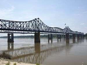
The opening of I-20 parallel to US 80 occurred in stages between 1960 and 1977.[55][56] This gradually transformed US 80 from being the major highway across northern Louisiana to serving local traffic along the I-20 corridor. However, the highway has remained physically independent from I-20 with one exception. In 1980, the closing of the old Vicksburg Bridge to vehicular traffic resulted in US 80 being shifted onto the newer I-20 Vicksburg Bridge to cross the Mississippi River.[57]
Alabama
The 1965 Selma to Montgomery marches followed US 80 between the two cities. In 1996, this route was designated by the National Park Service as the Selma to Montgomery National Voting Rights Trail. An interpretive center is located along the route in Lowndes County and the various sites used as campgrounds are marked along the route.
Major intersections
- Texas


.svg.png)

- Louisiana


- Mississippi


- Alabama


.svg.png)


- Georgia


- Butler Avenue/Inlet Avenue/Tybrisa Street in Tybee Island
See also
Related routes
References
- ↑ Bureau of Public Roads & American Association of State Highway Officials (November 11, 1926). United States System of Highways Adopted for Uniform Marking by the American Association of State Highway Officials (Map). 1:7,000,000. Washington, DC: United States Geological Survey. OCLC 32889555. Retrieved November 7, 2013 – via University of North Texas Libraries.
- ↑ "End of US highway 80". Endpoints of U.S. Highways. Retrieved July 4, 2006.
- ↑ "U.S. Route Number Database" (December 2009 ed.). American Association of State Highway and Transportation Officials. Retrieved December 6, 2013.
- 1 2 3 Weingroff, Richard F. (October 17, 2013). "U.S. Route 80: The Dixie Overland Highway". Highway History. Federal Highway Administration. Retrieved April 1, 2015.
- ↑ Hunsucker, Adam (June 25, 2017). "The Scenic Route: Simsboro to the Mississippi River". The News Star. Retrieved October 14, 2018.
- ↑ Guinn, Jeff (2009). Go Down Together: The True, Untold Story of Bonnie and Clyde. Simon and Schuster. p. 294. ISBN 1416557180.
- ↑ Milner, E. R. (2003). "Epilogue". The Lives and Times of Bonnie & Clyde. SIU Press. p. 157. ISBN 0809325527.
- ↑ California Department of Transportation; California State Transportation Agency (January 2015). 2014 Named Freeways, Highways, Structures and Other Appurtenances in California. Sacramento: California Department of Transportation. p. 111. Archived from the original (PDF) on May 30, 2015. Retrieved May 30, 2015.
- 1 2 Davis, Shaq (September 21, 2018). "Arizona's portion of U.S. Route 80, opened in 1926, wins 'Historic Road' status". Arizona Daily Star. Retrieved September 21, 2018.
- ↑ Guidry, Leigh (August 28, 2018). "Take the back roads with us. The Guidrys are cruising Louisiana's byways". The Daily Advertiser. Retrieved September 27, 2018.
- ↑ "Tucson's Miracle Mile listed in the National Register of Historic Places". Webpage. Tucson Historic Preservation Foundation. December 2017. Retrieved August 24, 2018.
- ↑ Clinco, Demion (May 2016). "Historic Arizona U.S. Route 80 Historic Highway Designation Application" (PDF). Application Document. Tucson Historic Preservation Foundation. p. 251. Retrieved August 24, 2018.
- ↑ Transportation Planning and Programming Division (n.d.). "State Highway No. 20". Highway Designation Files. Texas Department of Transportation.
- ↑ Transportation Planning and Programming Division (n.d.). "State Highway Loop No. 416". Highway Designation Files. Texas Department of Transportation.
- ↑ Transportation Planning and Programming Division (n.d.). "State Highway Loop No. 519". Highway Designation Files. Texas Department of Transportation.
- ↑ Transportation Planning and Programming Division (n.d.). "Business Interstate Highway No. 20-B". Highway Designation Files. Texas Department of Transportation.
- ↑ Transportation Planning and Programming Division (n.d.). "State Highway Spur No. 57". Highway Designation Files. Texas Department of Transportation.
- ↑ Transportation Planning and Programming Division (n.d.). "Business Interstate Highway No. 20-D". Highway Designation Files. Texas Department of Transportation.
- ↑ Transportation Planning and Programming Division (n.d.). "Business Interstate Highway No. 20-E". Highway Designation Files. Texas Department of Transportation.
- ↑ Transportation Planning and Programming Division (n.d.). "State Highway Spur No. 268". Highway Designation Files. Texas Department of Transportation.
- ↑ Transportation Planning and Programming Division (n.d.). "State Highway Loop No. 214". Highway Designation Files. Texas Department of Transportation.
- ↑ Transportation Planning and Programming Division (n.d.). "State Highway Loop No. 402". Highway Designation Files. Texas Department of Transportation.
- ↑ Transportation Planning and Programming Division (n.d.). "State Highway Loop No. 333". Highway Designation Files. Texas Department of Transportation.
- ↑ Transportation Planning and Programming Division (n.d.). "State Highway Loop No. 377". Highway Designation Files. Texas Department of Transportation.
- ↑ Transportation Planning and Programming Division (n.d.). "State Highway Loop No. 316". Highway Designation Files. Texas Department of Transportation.
- ↑ Transportation Planning and Programming Division (n.d.). "State Highway Loop No. 237". Highway Designation Files. Texas Department of Transportation.
- ↑ Transportation Planning and Programming Division (n.d.). "State Highway Loop No. 170". Highway Designation Files. Texas Department of Transportation.
- ↑ Transportation Planning and Programming Division (n.d.). "State Highway Loop No. 432". Highway Designation Files. Texas Department of Transportation.
- ↑ Transportation Planning and Programming Division (n.d.). "State Highway Loop No. 319". Highway Designation Files. Texas Department of Transportation.
- ↑ Transportation Planning and Programming Division (n.d.). "State Highway Loop No. 39". Highway Designation Files. Texas Department of Transportation.
- ↑ Transportation Planning and Programming Division (n.d.). "State Highway Loop No. 320". Highway Designation Files. Texas Department of Transportation.
- ↑ Transportation Planning and Programming Division (n.d.). "State Highway Loop No. 355". Highway Designation Files. Texas Department of Transportation.
- ↑ Transportation Planning and Programming Division (n.d.). "Farm to Market Road No. 18". Highway Designation Files. Texas Department of Transportation.
- ↑ Transportation Planning and Programming Division (n.d.). "State Highway Loop No. 425". Highway Designation Files. Texas Department of Transportation.
- ↑ Transportation Planning and Programming Division (n.d.). "Farm to Market Road No. 2945". Highway Designation Files. Texas Department of Transportation.
- ↑ Transportation Planning and Programming Division (n.d.). "State Highway No. 206". Highway Designation Files. Texas Department of Transportation.
- ↑ Transportation Planning and Programming Division (n.d.). "State Highway No. 69". Highway Designation Files. Texas Department of Transportation.
- ↑ Transportation Planning and Programming Division (n.d.). "Farm to Market Road No. 3363". Highway Designation Files. Texas Department of Transportation.
- ↑ Transportation Planning and Programming Division (n.d.). "State Highway Loop No. 254". Highway Designation Files. Texas Department of Transportation.
- ↑ Transportation Planning and Programming Division (n.d.). "State Highway Spur No. 312". Highway Designation Files. Texas Department of Transportation.
- ↑ Transportation Planning and Programming Division (n.d.). "State Highway Spur No. 580". Highway Designation Files. Texas Department of Transportation.
- ↑ 1967 Texaco map of Texas (Map). Retrieved October 9, 2014 – via AARoads.
- ↑ Transportation Planning and Programming Division (n.d.). "State Highway No. 180". Highway Designation Files. Texas Department of Transportation.
- ↑ Transportation Planning and Programming Division (n.d.). "State Highway Loop No. 260". Highway Designation Files. Texas Department of Transportation. =
- ↑ Transportation Planning and Programming Division (n.d.). "State Highway No. 1". Highway Designation Files. Texas Department of Transportation.
- ↑ Transportation Planning and Programming Division (n.d.). "State Highway Loop No. 354". Highway Designation Files. Texas Department of Transportation.
- ↑ 1954 TXDOT map (Map). Retrieved October 9, 2014 – via AARoads.
- ↑ Transportation Planning and Programming Division (n.d.). "Farm to Market Road No. 740". Highway Designation Files. Texas Department of Transportation.
- ↑ "Act No. 95, House Bill No. 206". State-Times. Baton Rouge. November 29, 1921. p. 9.
- ↑ Louisiana Department of Highways (July 1, 1955). Louisiana Highways: Interim Road Map (Map). Scale not given. Baton Rouge: Louisiana Department of Highways.
- ↑ "New Vicksburg Bridge Is Opened to Traffic". The New Orleans Item. New Orleans. April 29, 1930. p. 15.
- ↑ Frampton, Charles E. (October 7, 1931). "Dixie First Highway Completed". The New Orleans Item. New Orleans. pp. 1, 6.
- ↑ "Toll-Free Span Open". The New Orleans Item. New Orleans. October 29, 1933. p. 13.
- ↑ "New Bridge at Monroe Dedicated". The New Orleans Item. New Orleans. October 7, 1931. p. 1.
- ↑ Wagner, Robert (April 24, 1960). "Highway Unit Is Dedicated". The Times-Picayune. New Orleans. sec. 1, p. 28.
- ↑ "Interstate 20 Open; Last Stretch Finished". The States-Item. New Orleans. June 2, 1977. p. A4.
- ↑ Special Committee on U.S. Route Numbering (June 22, 1980). "Route Numbering Committee Agenda Showing Action Taken by the Executive Committee" (PDF) (Report). Washington, DC: American Association of State Highway and Transportation Officials. p. 4. Retrieved October 25, 2017 – via Wikimedia Commons.
External links
- United States Route 80: The Dixie Overland Highway - Federal Highway Administration
- Highway 80 - The Broadway of America
- Endpoints of U.S. Highway 80
- Historic California Highway 80 Corporation
- Selma to Montgomery National Voting Rights Trail - a U.S. National Historic Trail
Routes in italics are no longer a part of the system. Highlighted routes are considered main routes of the system. |
| Browse numbered routes | ||||
|---|---|---|---|---|
| ← | TX | SH 80 | ||
| ← | MS | US 82 | ||
| ← | AL | SR 81 | ||