Xenia Township, Greene County, Ohio
| Xenia Township, Greene County, Ohio | |
|---|---|
| Township | |
 | |
 Location of Xenia Township in Greene County | |
| Coordinates: 39°42′45″N 83°54′50″W / 39.71250°N 83.91389°WCoordinates: 39°42′45″N 83°54′50″W / 39.71250°N 83.91389°W | |
| Country | United States |
| State | Ohio |
| County | Greene |
| Area | |
| • Total | 43.9 sq mi (113.8 km2) |
| • Land | 43.6 sq mi (113.0 km2) |
| • Water | 0.3 sq mi (0.7 km2) |
| Elevation[1] | 928 ft (283 m) |
| Population (2010) | |
| • Total | 6,537 |
| • Density | 150/sq mi (57.8/km2) |
| Time zone | UTC-5 (Eastern (EST)) |
| • Summer (DST) | UTC-4 (EDT) |
| ZIP code | 45385 |
| Area code(s) | 937 |
| FIPS code | 39-86786[2] |
| GNIS feature ID | 1086176[1] |
| Website |
www |
Xenia Township is one of the twelve townships of Greene County, Ohio, United States. As of the 2010 census, the population was 6,537.[3]
Geography
Located at the center of the county, it borders the following townships:
- Miami Township - north
- Cedarville Township - northeast
- New Jasper Township - east
- Caesarscreek Township - southeast
- Spring Valley Township - southwest
- Beavercreek Township - west
- Bath Township - northwest
The city of Xenia, the county seat of Greene County, occupies much of Xenia Township, part of the city of Fairborn is in the northwest, and the census-designated place of Wilberforce is located in the township's northeast.
Name and history
Xenia Township was established in 1805.[4]
It is the only Xenia Township statewide.[5]
Government
The township is governed by a three-member board of trustees, who are elected in November of odd-numbered years to a four-year term beginning on the following January 1. Two are elected in the year after the presidential election and one is elected in the year before it. There is also an elected township fiscal officer,[6] who serves a four-year term beginning on April 1 of the year after the election, which is held in November of the year before the presidential election. Vacancies in the fiscal officership or on the board of trustees are filled by the remaining trustees.
Surrounding communities
Places adjacent to Xenia Township, Greene County, Ohio | |
|---|---|
References
- 1 2 "US Board on Geographic Names". United States Geological Survey. 2007-10-25. Retrieved 2008-01-31.
- ↑ "American FactFinder". United States Census Bureau. Archived from the original on September 11, 2013. Retrieved 2008-01-31.
- ↑ "Geographic Identifiers: 2010 Demographic Profile Data (G001): Xenia township, Greene County, Ohio". American Factfinder. U.S. Census Bureau. Retrieved January 18, 2017.
- ↑ Broadstone, Michael A. (1918). History of Greene County, Ohio: Its People, Industries and Institutions, Volume 1. B.F. Bowen. p. 271.
- ↑ "Detailed map of Ohio" (PDF). United States Census Bureau. 2000. Retrieved 2007-02-16.
- ↑ §503.24, §505.01, and §507.01 of the Ohio Revised Code. Accessed 4/30/2009.
- ↑ "County Map Front". Greene County Ohio. Retrieved August 28, 2013.
External links
Municipalities and communities of Greene County, Ohio, United States | ||
|---|---|---|
| Cities | 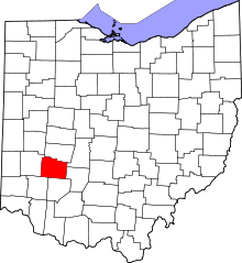 | |
| Villages | ||
| Townships | ||
| CDPs | ||
| Unincorporated communities | ||
| Footnotes | ‡This populated place also has portions in an adjacent county or counties | |