Port of Singapore
| Port of Singapore Pelabuhan Singapura 新加坡港口 (Xīnjiāpō Gǎngkǒu) சிங்கப்பூர் துறைமுகம் സിംഗപ്പൂർ തുറമുഖം (Ciṅkappūr Tuṟaimukam) | |
|---|---|
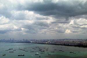 Ships lying at anchor outside the Port of Singapore | |
| Facility information | |
| Location | Singapore |
| Coordinates | 1°15′50″N 103°50′24″E / 1.264°N 103.840°E |
| Constructed | 1819 |
| Annual TEU | 32.2 million (2013)[1] |
| Shipping information | |
| No. of berths | 67 |
| Road information | |
| Street access | Ayer Rajah Expressway |
.jpg)
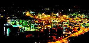
The Port of Singapore refers to the collective facilities and terminals that conduct maritime trade, and which handle Singapore's harbours and shipping. It is ranked as the top maritime capital of the world, since 2015.[2] Currently the world's second-busiest port in terms of total shipping tonnage, it also trans-ships a fifth[3] of the world's shipping containers, half of the world's annual supply of crude oil, and is the world's busiest transshipment port. It was also the busiest port in terms of total cargo tonnage handled until 2005, when it was surpassed by the Port of Shanghai. Thousands of ships drop anchor in the harbour, connecting the port to over 600 other ports in 123 countries and spread over six continents.
The Port of Singapore is not a mere economic boon, but an economic necessity because Singapore is lacking in land and natural resources. The Port is critical for importing natural resources, and then later re-exporting products after they have been refined and shaped in some manner, for example wafer fabrication or oil refining to generate revenue. The service industries such as hospitality services typical of a port of call restock the food and water supplies on ships. Ships pass between the Indian Ocean and the Pacific Ocean through the Singapore Strait. The Straits of Johor on the country's north are impassable for ships due to the Johor-Singapore Causeway, built in 1923, which links the town of Woodlands, Singapore to the city of Johor Bahru in Malaysia.
History
Before 1819
In the late 13th century, a Kingdom known as Singapura was established on the north bank of the Singapore River around what was called the Old Harbour. It was the only port in the southern part of the Strait of Malacca and serviced ships and traders in the region, competing with other ports along the coast of the Malacca Strait such as Jambi, Kota Cina, Lambri, Semudra, Palembang, South Kedah and Tamiang. The port had two functions. First, it made available products that were in demand by international markets; according to the Daoyu Zhilüe (Brief Annals of Foreign Islands, 1349)[4] by Chinese trader Wang Dayuan (born 1311, fl. 1328–1339), these included top-quality hornbill casques,[5] lakawood and cotton. Although these goods were also available from other Southeast Asian ports, those from Singapore were unique in terms of their quality. Secondly, Singapore acted as a gateway into the regional and international economic system for its immediate region. South Johor and the Riau Archipelago supplied products to Singapore for export elsewhere, while Singapore was the main source of foreign products to the region. Archaeological artefacts such as ceramics and glassware found in the Riau Archipelago evidence this. In addition, cotton was transshipped from Java or India through Singapore.[6]
By the 15th century, Singapore ily had declined as an international trading port due to the ascendance of the Malacca Sultanate. Local trade continued on the island. A map of Singapore by Portuguese mathematician Manuel Godinho de Eredia showed the location of Xabandaria or the office of a shahbandar, the Malay official responsible for international trade. Shards of 15th-century Siam ceramics and late 16th – or early 17th-century Chinese blue and white porcelain have been found at the Singapore and Kallang Rivers. Singapore also provided other regional ports with local products demanded by international markets. For instance, blackwood (a generic term used by Europeans to refer to rosewood) was exported from Singapore to Malacca, and was in turn purchased by Chinese traders and shipped to China for furniture-making:)
In the early 17th century, Singapore's main settlement and its port were destroyed by a punitive force from Aceh. After this incident, there was no significant settlement or port at Singapore until 1819 when Sir Stamford Raffles, excited by the deep and sheltered waters in Keppel Harbour, established for Britain a new settlement and international port on the island or an trading port .[6]
1819–1960

Keen to attract Asian and European traders to the new port, Raffles directed that land along the banks of the Singapore River, particularly the south bank, be reclaimed where necessary and allocated to Chinese and English country traders to encourage them to establish a stake in the port-settlement. Chinese traders, because of their frequent commercial interactions with Southeast Asian traders throughout the year, set up their trading houses along the lower reaches of the river, while English country traders, who depended on the annual arrival of trade from India, set up warehouses along the upper reaches. The port relied on three main networks of trade that existed in Southeast Asia at that time: the Chinese network, which linked Southeast Asia with the southern Chinese ports of Fujian and Guangdong; the Southeast Asian network, which linked the islands of the Indonesian archipelago; and the European and Indian Ocean network, which linked Singapore to the markets of Europe and the Indian Ocean littoral. These networks were complementary, and positioned Singapore as the transshipment point of regional and international trade. By the 1830s, Singapore had overtaken Batavia (now Jakarta) as the centre of the Chinese junk trade, and also become the centre of English country trade, in Southeast Asia. This was because Southeast Asian traders preferred the free port of Singapore to other major regional ports which had cumbersome restrictions. Singapore had also supplanted Tanjung Pinang as the export gateway for the gambier and pepper industry of the Riau–Lingga Archipelago by the 1830s, and South Johor by the 1840s. It had also become the centre of the Teochew trade in marine produce and rice.[6]
As the volume of its maritime trade increased in the 19th century, Singapore became a key port of call for sailing and steam vessels in their passage along Asian sea routes. From the 1840s, Singapore became an important coaling station for steam shipping networks that were beginning to form. Towards the late 19th century, Singapore became a staple port servicing the geographical hinterland of the Malay Peninsula. Following the institution of the British Forward Movement, Singapore became the administrative capital of British Malaya. Roads and railways were developed to transport primary materials such as crude oil, rubber and tin from the Malay Peninsula to Singapore to be processed into staple products, and then shipped to Britain and other international markets. During the colonial period, this was the most important role of the port of Singapore.[6]
Since 1963
Singapore ceased to be part of the British Empire when it merged with Malaysia in 1963. Singapore lost its hinterland and was no longer the administrative or economic capital of the Malay Peninsula. The processing in Singapore of raw materials extracted in the Peninsula was drastically reduced due to the absence of a common market between Singapore and the Peninsular states.[6]
Since Singapore's full independence in 1965, it has had to compete with other ports in the region to attract shipping and trade at its port. It has done so by developing an export-oriented economy based on value-added manufacturing. It obtains raw or partially manufactured products from regional and global markets and exports value-added products back to these markets through market access agreements such as World Trade Organization directives and free trade agreements.[6]
By the 1980s, maritime trading activity had ceased in the vicinity of the Singapore River except in the form of passenger transport, as other terminals and harbours took over this role. Keppel Harbour is now home to three container terminals. Other terminals were built in Jurong and Pasir Panjang as well as in Sembawang in the north. Today, the port operations in Singapore are handled by two players: PSA International (formerly the Port of Singapore Authority) and Jurong Port, which collectively operate six container terminals and three general-purpose terminals around Singapore.
In the 1990s the Port became more well-known and overtook Yokohama, and eventually became the busiest port in terms of shipping tonnage.

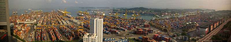
Operations

The port is the world's busiest port in terms of shipping tonnage handled, with 1.15 billion gross tons (GT) handled in 2005. In terms of cargo tonnage, Singapore is behind Shanghai with 423 million freight tons handled. The port retains its position as the world's busiest hub for transshipment traffic in 2005, and is also the world's biggest bunkering hub, with 25 million tonnes sold in the same year.[7]
Singapore is ranked first globally in 2005 in terms of containerised traffic, with 23.2 million Twenty-foot equivalent units (TEUs) handled. High growth in containerised traffic has seen the port overtaking Hong Kong since the first quarter of 2005,[8] and has led the race ever since, with an estimated 19,335 kTEUs handled in the year up to October, compared to 18,640 kTEUs handled in Hong Kong in the same period. A rise in regional traffic consolidating the port's position in Southeast Asia, and increases in transshipment traffic using the strategic East Asia-Europe route via Singapore helped the port to emerge tops at the end of the year, a title it had not held since overtaking Hong Kong once in 1998.
Operators
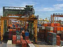
PSA Singapore's container facilities are as follows:
- Container berths: 52
- Quay length: 15,500 m
- Area: 600 hectares
- Max draft: 16 m
- Quay cranes: 190
- Designed capacity: 35,000 kTEU
PSA Singapore has 13 berths which are part of the Pasir Panjang Container Terminal's Phase Two which are due for completion by 2009. Phase Three and Four will add another 16 berths and are expected to be completed by 2013.[9]
Jurong Port's facilities are as follows:
- Berths: 32
- Berth length: 5.6 km
- Maximum vessel draft: 15.7 m
- Maximum vessel size: 150,000 tonnes deadweight (DWT)
- Area: 127 Hectares Free Trade Zone, 28 Hectares non-Free Trade Zone
- Warehouse facilities: 178,000 m²
PSA Singapore also has a 40-year contract to operate the tax-free Gwadar Port on the southwestern coast of Pakistan. Gwadar started operation in March 2008, with 3 multi-purpose berths, a 602-meter quay, and 12.5 meter depth. Another 9 berths are under construction, with a 20-meter depth.
Terminals
| Port | Operator | Type | Berths | Quay length | Quay cranes | Area (Ha) | Capacity (kTEU) | |
|---|---|---|---|---|---|---|---|---|
| Brani (BT) | PSA[10] | Container | 8 | 2,400 | 29 | 84 | ||
| Cosco-PSA (CPT) | Cosco/PSA | Container | 2 | 720 m | 22.8 | >1,000 | ||
| Jurong | JTC | Multi-Purpose | 32 | 5,600 | 155 | |||
| Keppel (KT) | PSA | Container | 14 | 3,200 | 36 | 105 | ||
| Pasir Panjang (PPT 1) | PSA | Container | 7 | 2,500 | 28 | 88 | ||
| Pasir Panjang (PPT 2) | PSA | Container | 7 | 2,300 | 28 | 120 | ||
| Pasir Panjang (PPT 3) | PSA | Container | 9 | 3,000 | 34 | 113 | ||
| Pasir Panjang (PPT 5) | PSA | Container | 5 | 1,850 | 22 | 111 | ||
| Pasir Panjang Wharves | PSA | General | ||||||
| Sembawang | PSA | General | 4 | 660 | 28 | |||
| Tanjong Pagar (TPT) | PSA | Container | 7 | 2,100 | 27 | 85 |
Cruise Business

Port of Singapore also has a terminal for cruise ships. Such cruise lines that home port there include Princess Cruises, Royal Caribbean, Holland America Line, and more. Princess will have the place as largest deployment by a premium cruise line when it deploys Sapphire Princess on three- to eleven-day roundtrip cruises to Asia. More than 40,000 passengers will be sailing on those cruises from November 2014 to February 2015. Stationing the ship in port will bring $50 million under contribution while Princess responds to a growing interest for Singapore-based cruises.
In popular culture
- The port was documented in a MegaStructures programme of the National Geographic Channel
- The Keppel Terminal of the port was featured in a Strike Force mission in Call of Duty: Black Ops II.
Tuas Megaport
The Tuas Megaport will be the only port in Singapore after the PSA city terminals close in 2027 and the Pasir Panjang Terminal in 2040, ending an era of port operations in the city area which started in 1819.[11] The Sea Transport Industry Transformation Map (ITM) launched by the Maritime and Port Authority (MPA) aims to grow the industry's value-add by $4.5 billion and create more than 5,000 new jobs by 2025.
Automation will be a key part of the new megaport, with over 1,000 battery-powered driverless vehicles and the world's largest fleet of almost 1,000 automated yard cranes to be developed for the port. Nelson Quek, PSA Singapore's head of Tuas planning stated that "Tuas, when it’s fully developed, is going to be the single largest fully-automated terminal in the world".[11]
The new port is projected to be twice the size of Ang Mo Kio new town.[11] It will have 8.6km of wharves and will have infrastructure to cater for the largest container ships in the world, like the Maersk’s Triple-E vessels.
See also
- List of East Asian ports
- Pulau Bukom
- Pulau Sebarok
- Jurong Island
Notes
- ↑ U-Wen, Lee (9 January 2014). "PSA Int'l 2013 container throughput up 2.9%". The Business Times. Singapore. p. 22.
- ↑ "Singapore named top maritime capital of the world for 3rd consecutive time". The Straits Times. 26 April 2017.
- ↑ http://www.singaporepsa.com/
- ↑ See 汪大渊 (Wang Dayuan); 苏继顷 (Su Jiqing) (comp.) (1981). 岛夷志略校释 (Pinyin: Dǎoyí Zhìlüè Jiàoshì) (Brief Annals of Foreign Islands : A Collation and Elucidation). Beijing: Zhonghua Shuju (China Publishing House).
- ↑ From the Middle French meaning "helmet", a casque is an anatomical structure suggestive of a helmet, such as the horny outgrowth on the head of a cassowary: see "Casque". Merriam–Webster's Online Dictionary. Retrieved 1 September 2007.
- 1 2 3 4 5 6 Heng, Derek. "Continuities and Changes : Singapore as a Port-City over 700 Years". Biblioasia. Singapore: National Library Board. 1 (1): 12–16. ISSN 0219-8126. .
- ↑ "Singapore remains world's busiest port". China View, Xinhua News Agency. 12 January 2006.
- ↑ Cher, Derek (21 November 2005). "Singapore port continues to outpace Hong Kong". Channel NewsAsia.
- ↑ "S'pore to spend $2b on port expansion". AsiaOne News. 21 December 2007.
- ↑ "Factsheet Singapore Terminals" (PDF). PSA Corporation Limited. Retrieved 5 September 2014.
- 1 2 3 Heng, Daniel (7 February 2018). "Why Singapore needs Tuas mega port to keep ruling the seas". Channel NewsAsia. Retrieved 12 March 2018.
Further reading
History
- Sinnappah Arasaratnam (1972). Pre-modern Commerce and Society in Southern Asia : An Inaugural Lecture Delivered at the University of Malaya on December 21, 1971. Kuala Lumpur: University of Malaya.
- Peter Borschberg “Three questions about maritime Singapore, 16th and 17th Centuries”, Ler História, 72 (2018): 31-54. https://journals.openedition.org/lerhistoria/3234
- Braddell, Roland (1980). A Study of Ancient Times in the Malay Peninsula and the Straits of Malacca and Notes on Ancient Times in Malaya / by Dato Sir Roland Braddell. Notes on the Historical Geography of Malaya / by Dato F.W. Douglas (MBRAS reprints; no. 7). Kuala Lumpur: Printed for the Malaysian Branch of the Royal Asiatic Society by Art Print. Works.
- Chiang, Hai Ding (1978). A History of Straits Settlements Foreign Trade, 1870–1915 (Memoirs of the National Museum; no. 6). Singapore: National Museum.
- Hall, Kenneth R. (1985). Maritime Trade and State Development in Early Southeast Asia. Honolulu, Hi.: University of Hawai'i Press. ISBN 0-8248-0959-9.
- Ishii, Yoneo (ed.) (1998). The Junk Trade from Southeast Asia : Translations from the Tosen Fusetsu-gaki, 1674–1723. Singapore: Institute of Southeast Asian Studies (ISEAS); Research School of Pacific and Asian Studies, Australian National History, Australian National University. ISBN 981-230-022-8.
- Miksic, John N. (1985). Archaeological Research on the "Forbidden Hill" of Singapore : Excavations at Fort Canning, 1984. Singapore: National Museum. ISBN 9971-917-16-5.
- Miksic, John N.; Cheryl-Ann Low Mei Gek (gen. eds.) (2004). Early Singapore 1300s–1819 : Evidence in Maps, Text and Artefacts. Singapore: Singapore History Museum. ISBN 981-05-0283-4.
- Ooi, Giok Ling; Brian J. Shaw (2004). Beyond the Port City : Development and Identity in 21st Century Singapore. Singapore: Prentice Hall. ISBN 0-13-008381-X.
- Shaffer, Lynda Norene (1996). Maritime Southeast Asia to 1500. Armonk, N.Y.: M.E. Sharpe. ISBN 1-56324-144-7.
- Trocki, Carl A. (1979). Prince of Pirates : The Temenggongs and the Development of Johor and Singapore, 1784–1885. Singapore: Singapore University Press. ISBN 9971-69-376-3.
Present day
- Yap, Chris (1990). A Port's Story, A Nation's Success. Singapore: Times Editions for Port of Singapore Authority.
- Ho, David K[im] H[in] (1996). The Seaport Economy: A Study of the Singapore Experience. Singapore: Singapore University Press. ISBN 9971-69-199-X.
- Singapore Shipping: Past, Present & Future. Singapore: Singapore Shipping Association. 2000.
- Danam, Jacqueline (ed.) (2003). PSA: Full Ahead. Singapore: PSA Corporation. ISBN 981-4068-47-0.
External links
| Wikimedia Commons has media related to Ports and harbours of Singapore. |
- Live Camera to Port of Singapore
- Official website of the Maritime and Port Authority of Singapore
- Landow, George P. "Singapore Harbor from its Founding to the Present : A Brief Chronology". Postcolonial Web. Archived from the original on 24 August 2007. Retrieved 1 September 2007.