Semarang
| Semarang | ||
|---|---|---|
| City | ||
|
Kota Semarang City of Semarang | ||
| Other transcription(s) | ||
| • Javanese | ꦏꦸꦛꦯꦼꦩꦫꦁ | |
| • Chinese | 三宝垄 | |
| • Arabic | سيمارانج | |
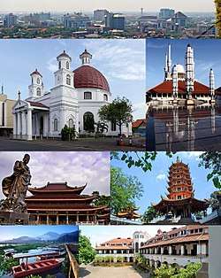 From top, left to right: Semarang city skyline, Semarang's Blenduk Church is the oldest Church in Central Java, The Great Mosque of Central Java, Gedung Batu Temple (the oldest Chinese temple), Pagoda Avalokitesvara, Rawa Pening (Pening swamp) water tourism, and iconic building of Lawang Sewu. | ||
| ||
| Nickname(s): Venetië van Java, Lumpia City | ||
| Motto(s): Semarang Kota ATLAS | ||
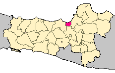 Location within Central Java | ||
| Coordinates: 6°58′S 110°25′E / 6.967°S 110.417°ECoordinates: 6°58′S 110°25′E / 6.967°S 110.417°E | ||
| Country |
| |
| Province |
| |
| Government | ||
| • Mayor | Hendrar Prihadi | |
| • Vice Mayor | Hevearita Gunaryanti Rahayu | |
| Area | ||
| • City | 373.78 km2 (144.32 sq mi) | |
| • Metro | 1,643.4 km2 (634.5 sq mi) | |
| Elevation | 4 m (13 ft) | |
| Population (2010) | ||
| • City | 1,555,984 | |
| • Density | 4,200/km2 (11,000/sq mi) | |
| • Metro | 3,183,516 | |
| • Metro density | 1,900/km2 (5,000/sq mi) | |
| Demonym(s) | Semarangian | |
| Demographics | ||
| • Ethnic groups |
Javanese Chinese Indian Arab Sundanese Batak Madura | |
| • Religion[1] |
Islam 86.78% Protestantism 6.91% Catholicism 4.97% Buddhism 0.64% Hinduism 0.10% Confucianism 0.07% Others 0.01% | |
| Time zone | UTC+7 (IWST) | |
| Area code | (+62) 24 | |
| Vehicle registration | H | |
| Website |
semarangkota | |


Semarang is the capital and largest city of Central Java province in Indonesia. It has an area of 373.78 square kilometres (144.32 sq mi) and a population of approximately 1.8 million people, making it Indonesia's fifth most populous city[2] after Jakarta, Surabaya, Bandung and Medan. The built-up (metro) area had 3,183,516 inhabitants at the 2010 census spread on 2 cities and 26 districts.[3] Greater Semarang (a.k.a. Kedungsapur) has a population of close to 6 million (see Greater Semarang section), and is located at 6°58′S 110°25′E / 6.967°S 110.417°E. A major port during the Dutch colonial era, and still an important regional center and port today, the city has a dominant Javanese population.
History
![]()
![]()
![]()
![]()
![]()
![]()
![]()
In 1678, Sunan Amangkurat II promised to give control of Semarang to the Dutch East India Company (VOC) as a part of a debt payment. In 1682, the Semarang state was founded by the Dutch colonial power. On 5 October 1705 after years of occupations, Semarang officially became a VOC city when Susuhunan Pakubuwono I made a deal to give extensive trade rights to the VOC in exchange of wiping out Mataram's debt. The VOC, and later, the Dutch East Indies government, established tobacco plantations in the region and built roads and railroads, making Semarang an important colonial trading centre.
The historic presence of a large Indo (Eurasian) community in the area of Semarang is also reflected by the fact a creole mix language called Javindo existed there.[4]
Classical Indische Town (1678–1870)
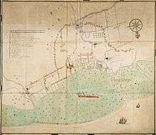
Semarang was handed by the Sultan of Mataram to the Dutch East Indies in 1678. The city was pictured as a small settlement with a pious Muslim area called Kauman, a Chinese quarter, and a Dutch fortress. The fortress has a pentagonal form with only one gate in the south and five monitoring towers to protect the Dutch settlement from rebellion actions, segregating the spaces between Dutch settlement and other areas.[5] In fact, the city of Semarang was only referred to the Dutch quarter while the other ethnic settlement were considered as villages outside the city boundary. The city, known as de Europeesche Buurt, was built in classical European style with church located in the centre, wide boulevards and streets skirted by beautiful villas.[6] According to Purwanto (2005),[7] the urban and architectural form of this settlement is very similar to the design principles applied in many Dutch cities, which begun to concern on the urban beautification.
Due to the long and costly Java War, there was not much funding from the Dutch East Indies government, which affected Semarang's development. The majority of land was used for rice fields and the only small improvement was the development of a surrounding fortress. Although less developed, Semarang has a fairly arranged city system, in which urban activities were concentrated along the river and the settlement was linked to a market where different ethnic groups met to trade. The existence of the market, in the later years, become a primary element and a generator of urban economic growth.[8]
An important influence on urban growth was the Great Mail Road project in the 1847, which connected all the cities in the northern coast of Central and East Java and positioned Semarang as the trade centre of agricultural production.[9] The project was soon followed by the development of the Netherlands Indies railway and the connecting roads into the inner city of Semarang at the end of 19th century.[8] Colombijn (2002)[9] marked the development as the shift of urban functions, from the former river orientation to all services facing the roads.
The modern city (1870–1922)
| Semarang | |||||||||||||||||||
| Chinese name | |||||||||||||||||||
|---|---|---|---|---|---|---|---|---|---|---|---|---|---|---|---|---|---|---|---|
| Traditional Chinese | 三寶壟 | ||||||||||||||||||
| Simplified Chinese | 三宝垄 | ||||||||||||||||||
| |||||||||||||||||||
| Javanese name | |||||||||||||||||||
| Javanese | ꦯꦼꦩꦫꦁ | ||||||||||||||||||
.svg.png)
Improved communication, the result of the Mail and Railway projects, brought an economic boom to the city in the 1870s. There were hospitals, churches, hotels, and large houses built along new main roads; Bojongscheweg, Pontjolscheweg, and Mataram street, densified population in the ethnic settlements and created the urban kampong (village).[6]
Urban growth densified the urban kampong, reaching 1,000 inhabitants per hectare and degrading the quality of living conditions.[10] In the early 20th century, mortality rate were high due to the overcrowding and lack of hygiene that triggered cholera and tuberculosis outbreaks.[11] Cobban (1993)[10] noted the ethical movement of kampongverbetering led by Henry Tillema in 1913 and the concern of the Advisor for Decentralisation for kampong improvement through the betterment of public toilets, drainage, and the planning of public housing.
In 1917, a healthy housing project was implemented in the Southern part of Semarang called Candi Baru. Thomas Karsten, the advisor for city planning, transformed the concept of ethnic segregation that divided previous urban settlements into a new housing district plan based on economic classes. Although practically the three ethnic groups were also divided into three economic classes where the Dutch and rich Chinese occupied the largest lots in the housing district,[6] Karsten had effectively emerged the developed district by integrating the road network, introducing newly improved public washing and bathing, squares and sporting facilities that could be used communally.[12] Following the Candi Baru, there were three other housing plans between 1916–1919 to accommodate a 55% population increase in Semarang; 45,000 Javanese, 8500 Chinese and 7000 Europeans. Karsten marked a new approach to town planning with emphasis on the aesthetic, practical and social requirements, articulated not in terms of race but economic zones.[12]
Driven by economic growth and spatial city planning, the city had doubled in size and expanded to the south by the 1920s, creating a nucleus of a metropolis where multi-ethnic groups lived and traded in the city. The villages in the suburbs such as Jomblang and Jatingaleh steadily became the satellite towns of Semarang, more populated with a bigger market area. Before the invasion of Japan in 1942, Semarang had already become the capital of Central Java Province, as the result of trade and industrial success and spatial planning.[6]
_in_Semarang_TMnr_10032316.jpg)
 A Chinese house in Semarang at the turn of the 20th century.
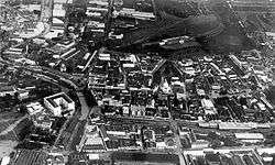 Aerial picture of Old Semarang area in 1920s.
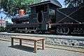 Old 0-6-0 locomotive next to the Lawang Sewu building.
Japanese occupation and early independence
The Japanese military occupied the city, along with the rest of Java, in 1942, during the Pacific War of World War II. During that time, Semarang was headed by a military governor called a Shiko, and two vice governors known as Fuku Shiko. One of the vice governors was appointed from Japan, and the other was chosen from the local population.
After Indonesian independence in 1945, Semarang became the capital of Central Java province.
Geography
Semarang is located on the northern coast of Java.
Climate
Semarang features a tropical rainforest climate that borders on a tropical monsoon climate (Am). The city features distinctly wetter and drier months, with June through August being the driest months. However, in none of these months does average precipitation fall below 60 mm, hence the tropical rainforest categorization. Semarang on average sees approximately 2800 mm of rain annually. Average temperatures in the city are relatively consistent, hovering around 28 degrees Celsius.
| Climate data for Semarang | |||||||||||||
|---|---|---|---|---|---|---|---|---|---|---|---|---|---|
| Month | Jan | Feb | Mar | Apr | May | Jun | Jul | Aug | Sep | Oct | Nov | Dec | Year |
| Average high °C (°F) | 29 (85) |
29 (85) |
30 (86) |
31 (88) |
32 (89) |
32 (89) |
32 (89) |
32 (89) |
32 (90) |
32 (90) |
31 (88) |
30 (86) |
31 (88) |
| Average low °C (°F) | 25 (77) |
25 (77) |
25 (77) |
26 (78) |
26 (78) |
25 (77) |
24 (76) |
24 (76) |
25 (77) |
26 (78) |
26 (78) |
25 (77) |
25 (77) |
| Average precipitation mm (inches) | 430 (16.93) |
360 (14.17) |
320 (12.6) |
230 (9.06) |
160 (6.3) |
80 (3.15) |
80 (3.15) |
60 (2.36) |
100 (3.94) |
160 (6.3) |
220 (8.66) |
330 (12.99) |
2,780 (109.45) |
| Source: Weatherbase [13] | |||||||||||||
Demography
The dominant Semarang ethnic is Javanese, followed by minorities of Chinese, India, Arab, and others (including local ethnics such as Sundanese, Batak, Madura, etc.). The majority religion adopted is Islam.
Semarang has a large Chinese community. As in other regions of Java, especially in Central Java, they have mingled closely with the local population and use Javanese in communication for hundreds of years. About 4-5 % of the city's population is ethnic Chinese, many residing in a Chinatown in the vicinity of Gang Pinggir. The Chinatown is called "Kampong Pecinan Semawis" and expresses many aspects of traditional Chinese culture including foods, rituals, and houses of worship.
Economy
As the capital city of central Java, and fifth largest city of Indonesia, economy of Semarang is quite large. Semarang has transformed and changed dynamically towards a better direction. In a period of less than 10 years, Semarang Metropolitan continues to build a vital financial contribution to Indonesia due to the growing trade and industry and services. As a consequence, people's purchasing power increased, capital inflows, consumer confidence and doing business indexes were relatively conducive to the development of several Central business district such as Simpang Lima City Center (SLCC), Pemuda Central Business District (PCBD), and Gajahmada Golden Triangle (GGT).
Transport
Air
Semarang's General Achmad Yani International Airport is served by a number of operators including AirAsia, Garuda Indonesia, Sriwijaya Air and Lion Air which provide services to Jakarta, Bali, Kuala Lumpur, and Singapore.[14]
Road
The primary means of public transportation is by minibus, called "bis." Semarang's largest bus terminals are Mangkang and Terboyo.[15]
A bus rapid transit serves Semarang, called Trans Semarang.[16]
Semarang has a toll road, the Semarang Toll Road.[17] The Semarang–Solo Toll Road is under construction.[18]
Semarang is on Indonesian National Route 1 that connects it to Merak and Ketapang (Banyuwangi). Indonesian National Route 14 toward Bawen starts here.
Rail
Semarang was connected to Surakarta (Solo) by a rail line in 1870.[19] At present there are two large train stations in Semarang: Semarang Poncol and Semarang Tawang. Semarang is connected to Bandung, Jakarta, and Surabaya by inter-city train services.
Sea
The main seaport is the Tanjung Mas seaport.
Semarang River and flood control
Like Singapore River, Semarang is constructing Semarang River at Banjir Kanal Barat (Garang River) near Karangayu Bridge. In the middle of July 2011, gardens in river banks and some traditional boats are available to use. The project will be finished in 2013 with river gardens, trotoars, garden lighting, water activities, art sites, sport sites and balconies and stairs for sightseeing.[20] In August 2011, a 421 metres (1,381 ft) tunnel dodger at Kreo river has been finished and Jatibarang Dam construction can begin, with completion targeted for July 2013. The dam is planned to ease 230 cubic metres (8,100 cu ft) per second of flood water and will generate 1.5 Megawatts of electricity, provide a drinking water resource and a boost to tourism.[21]
Sights and landmarks
Tugu Muda
Tugu Muda (English "Young Monument") is a monument built to commemorate the services of the heroes who have fallen in the Battle of Five Days in Semarang. The height of Tugu Muda is 53 meters. Tugu Muda is located in front of Lawang Sewu at Pemuda street. It depicts the Tugu Muda fighting spirit and patriotism of Semarang residents, especially the youth who are persistent, self-sacrificing in high spirits maintaining the independence of Indonesia. The laying of the first stone took place on 28 October 1945, by Mr. Wongsonegoro (Governor of Central Java) at the originally planned location is near the square. [22]
Temples


The Sam Poo Kong temple is the oldest Chinese temple in the city.[23]
Education
There are 593 elementary schools, 220 junior high schools, 106 senior high schools, and 88 vocational high schools, both public and private in Semarang.[24]
There are 20 universities in Semarang, 12 of them private and 8 public. The most renowned universities of Semarang are Diponegoro University and Soegijapranata University.
- Dipenegoro University (UNDIP): It is one of national or state-owned universities in Semarang, founded in 1956. The university has 11 faculties: Faculty of Economics and Business, Faculty of Social and Political Sciences, Faculty of Humanities, Faculty of Law, Faculty of Medicine, Faculty of Engineering, Faculty of Fishery and Marine Sciences, Faculty of Natural Sciences and Mathematics, Faculty of Public Health, Faculty of Animal Agriculture, and Faculty of Psychology. The university also offers a postgraduate program.
- Soegijapranata Catholic University (UNIKA): It is one of the private universities in Semarang, founded in 1982. There are 8 faculties in UNIKA: Faculty of Architecture and Design, Faculty of Law and Communication, Faculty of Engineering, Faculty of Language and Arts, Faculty of Economics and Business, Faculty of Agricultural and Technology, Faculty of Psychology, and Faculty of Computer Science.
Sport centres
There are several sport centres in Semarang. Jatidiri sport centre or Jatidiri Stadium is one of the biggest sport centres in Semarang, located in Karangrejo, Gajahmungkur. The centre comprises a soccer field, in line skate track, tennis filed, climbing wall, swimming pool, and many others. The capacity of the centre is about 21.000 people.[25]
Knight Stadium is a futsal and basketball centre in Semarang, located in Grand Marina complex. There is a café and fitness centre in Knight Stadium.[26]
Culture
Food
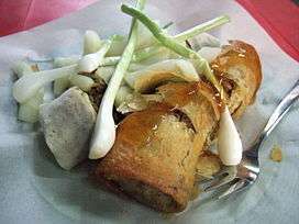
Semarang is widely known for its Bandeng presto (pressure-cooked milkfish), Lumpia, Wingko, Tahu Gimbal, and Ganjel Rel. Semarang has also been called 'The city of Jamu' because it is an important centre for the production of jamu which are a wide range of Indonesian herbal medicines that are very popular across Indonesia.[27]
Festivals
Dugderan is an annual festival in Semarang desecrated to welcome the Ramadan month (a fasting month for Moslems). The word "dug" describes the sound of bedug (traditional Indonesian musical instrument). The word "der" describes the sound of fireworks.
The icon of the festival is a special puppet dragon-like animal called Warak Ngendog. The word "warak" stands for "holy" and the word "ngendog" expresses a reward for Moslems. Warak Ngendog’s feet are chained, representing people’s desire that should be postponed during this holy month. As Dugderan is a festival unique for Semarang, it represents an important attraction for both local and non-residential people.[28]
Adipura Award
Semarang has got Adipura Award for 6 times in a row since 2012. Adipura Award is given for achievement in cleanliness and greenery at parks, streets, markets, shop buildings, premises, schools, even cleanliness of water ways and rivers.[29]
Greater Semarang
Greater Semarang was initially defined by the government as Semarang, Semarang Regency, the newly carved Salatiga city, Kendal Regency, and Demak Regency.[30] Despite the definition, this includes a lot of rural areas and the urban cores remain distinct; they have not amalgamated into a characterless metro area as in Greater Jakarta.
| Administrative division | Area (km²) | Population '000s (2000 Census) | Population '000s (2010 Census) | Population '000s (2015 Census) | Population density (/km²) |
|---|---|---|---|---|---|
| Semarang Municipality | 373.67 | 1,339 | 1,556 | 1,699 | 4,547 |
| Semarang Regency | 946.86 | 843 | 931 | 1,000 | 1,056.1 |
| Salatiga Municipality | 52.96 | 151 | 170 | 181 | 3,417.7 |
| Kendal Regency | 1,002.27 | 850 | 900 | 942 | 939 |
| Demak Regency | 897.43 | 974 | 1056 | 1117 | 1244.7 |
| Grobogan Regency | 1,975.865 | 1,268 | 1,309 | 1,351 | 683.7 |
| Greater Semarang | 5,287.96 | 5,425,000 | 5,922,000 | 6,290,000 | 1,189.7 |
Sources: BPS Jateng[31]
Notable people born in Semarang
- Agung Laksono, politician and former Chairman of the House of Representatives.
- Anindya Kusuma Putri, Puteri Indonesia 2015 and Top 15 of Miss Universe 2015.
- Anne Avantie, fashion designer.
- Conrad Emil Lambert Helfrich, Dutch admiral.
- Daniel Sahuleka, Dutch musician.
- Fuad Hassan, politician, former Minister of Education and Culture.
- Hubertus van Mook, Dutch politician.
- Liem Bwan Tjie, architect.
- Oei Tiong Ham, Chinese Indonesian tycoon.
- P. F. Dahler, politician, member of Investigating Committee for Preparatory Work for Independence (BPUPK).
- Purnomo Yusgiantoro, politician and current Minister of Defence.
- Raden Saleh, painter.
- Rob Nieuwenhuys, literary historian and author.
- Sutiyoso, chief of Indonesian Intelligence Bureau (BIN).
- Tukul Arwana, comedian and television personality.
- Willem Einthoven, medical doctor, invented electrocardiography (ECG), Nobel Prize winner.
- Stella Cornelia, singer and actress, ex-member of JKT48
- Max van Egmond, bass and baritone singer of Baroque and Renaissance music.
Sister cities
Semarang is twinned with:
References
- ↑ "Peringatan". sp2010.bps.go.id.
- ↑ "Jumlah Penduduk Kota Semarang" [Population of Semarang] (in Indonesian). Dinas Kependudukan dan Pencatatan Sipil Kota Semarang. October 2015. Retrieved 28 December 2016.
- ↑ "Indonesia: Java (Regencies, Cities and Districts) - Population Statistics, Charts and Map". www.citypopulation.de.
- ↑ De Gruiter, Miel. "Javindo, a contact language in pre-war Semarang". (Peter Bakker & Maarten Mous. Mixed Languages: 15 Case Studies in Language Intertwining. Amsterdam: IFOTT. 1994.) pp. 151–159.
- ↑ Purwanto, L. M. F. (2005). Kota Kolonial Lama Semarang. Dimensi Teknik Arsitektur, 33(1), 27-33
- 1 2 3 4 Pratiwo. (2005). The City Planning of Semarang 1900–1970. In F. Colombijn, M. Barwegen, P. Basundoro & J. A. Khusyairi (Eds.), Old City, New City: The History of the Indonesian City Before and After Independence. Yogyakarta: Penerbit Ombak.
- ↑ Purwanto, L. M. F. (2005). Kota Kolonial Lama Semarang. Dimensi Teknik Arsitektur, 33(1), 27-33.
- 1 2 Nas, P. J. M., & Pratiwo. (2002). Java and De Groote Postweg, La Grande Route, the Great Mail Road, Jalan Raya Pos’. Bijdragen tot de Taal-, Land-en Volkenkunde, 158(4), 707–725.
- 1 2 Colombijn, F. (2002). Introduction; On the road. Bijdragen tot de Taal-, Land-en Volkenkunde, 158(4), 595-617.
- 1 2 Cobban, J. L. (1993). Public Housing in Colonial Indonesia 1900–1940. Modern Asian Studies, 27(04), 871-896.
- ↑ Silver, C. (2008). Planning the megacity: Jakarta in the twentieth century: Psychology Press.
- 1 2 Cote, J. (2004). Colonial designs: Thomas Karsten and the planning of urban Indonesia. Imprint, 2004, 01-01.
- ↑ "Weatherbase: Weather for Semarang, Indonesia". Weatherbase. 2011. Retrieved 1 December 2011.
- ↑ "Flights". Semarang. Lonely Planet. Retrieved 3 December 2015.
- ↑ "Terminal Terboyo Rusak Parah, Terminal Mangkang Sepi". Jawa Pos (in Indonesian). 13 June 2016. Retrieved 28 December 2016.
- ↑ Purbaya, Angling Adhitya (8 December 2016). "Pengguna Angkutan Umum Meningkat, Kota Semarang Diganjar Penghargaan". detikNews (in Indonesian). Retrieved 28 December 2016.
- ↑ "Semarang". Jasa Marga. Archived from the original on 4 December 2016. Retrieved 28 December 2016.
- ↑ Munir, Syahrul (6 December 2016). Alexander, Hilda B, ed. "Tol Bawen-Salatiga Dijadwalkan Beroperasi Maret 2017". Kompas. Retrieved 28 December 2016.
- ↑ Cohen, Matthew Isaac (2006). The Komedie Stamboel: Popular Theater in Colonial Indonesia, 1891-1903. Ohio University Press. p. 90. ISBN 978-0-89680-246-9.
- ↑ Isti, Bambang (16 July 2011). "Eloknya Singapore River di Banjirkanal Barat". Suara Merdeka (in Indonesian). Archived from the original on 28 December 2016. Retrieved 28 December 2016.
- ↑ Wijaya, Royce (13 August 2011). "Bendungan Utama Waduk Jatibarang Dikerjakan". Suara Merdeka. Archived from the original on 10 May 2013.
- ↑ "13 must-visit places in Semarang". The Jakarta Post. Retrieved 3 December 2017.
- ↑ Suherdjoko (8 February 2016). "It's Chinese New Year for all in Semarang". The Jakarta Post. Retrieved 8 February 2016.
- ↑ "Data Referensi Pendidikan" (in Indonesian). Ministry of Education. Retrieved 18 March 2017.
- ↑ "GOR Jatidiri". Seputar Semarang. Retrieved 18 March 2017.
- ↑ "Knight Stadium Futsal". Seputar Semarang. Retrieved 18 March 2017.
- ↑ Kamah, Wahyuni (26 March 2012). "Semarang: Indonesia's City of Jamu". The Jakarta Globe. Archived from the original on 21 June 2013.
- ↑ "Tradisi Dugderan di Kota Semarang". Mata Sejarah. Archived from the original on 12 April 2017. Retrieved 18 March 2017.
- ↑ Yunita, Niken Widya (3 August 2017). "Pemkot Semarang Raih Adipura 6 Kali Berturut-turut". Detik News. Retrieved 5 October 2018.
- ↑ Soetomo, Sugiono (2004). "Urban Development as the interface of Regional Development from Below in central Java - Indonesia: the Case of Semarang Metropolitan" (PDF). 40th ISoCaRP Congress. International Society of City and Regional Planners. Retrieved 28 December 2016.
- ↑ https://jateng.bps.go.id/website/pdf_publikasi/Profil-Penduduk--Jawa-Tengah-Hasil-Supas-2015.pdf%5Bpermanent+dead+link%5D
- ↑ "Semarang - Indonesia". Brisbane City Council. Archived from the original on 15 March 2011.
- ↑ Mardiani, Dewi (6 September 2012). "Kerja Sama Sister City Semarang-Da Nang Akan Ditingkatkan". Republika. Retrieved 28 December 2016.
- ↑ "Marzuki: Hubungan Indonesia-Vietnam Harus Ditingkatkan" (in Indonesian). Antara. 5 September 2012. Archived from the original on 6 March 2014 – via Yahoo News.
- Graaf, H. J. de (Hermanus Johannes), 1899-(?),
"Chinese Muslims in Java in the 15th and 16th centuries : the Malay Annals of Semarang and Cerbon / translated and provided with comments by H.J. de Graaf and Th.G.Th. Pigeaud; edited by M.C. Ricklefs. Publisher: [Melbourne] : Monash University, 1984. Description: xiii, 221 p. : folded map ; 21 cm. ISBN 0-86746-419-4 : Series: Monash papers on Southeast Asia ; no. 12
External links
| Wikimedia Commons has media related to Semarang. |
- Official website (in Indonesian)

- Official website (in Indonesian)
Regencies and cities of Central Java | ||
|---|---|---|
Capital: Semarang | ||
| Regencies |  | |
| Cities | ||
| 2,000,000 and more | |
|---|---|
| 1,000,000-1,999,999 | |
| 400,000-999,999 | |
| 200,000-399,999 | |