Transport in Azerbaijan

The transport in Azerbaijan involves air traffic, waterways and railroads. All transportation services in Azerbaijan except for oil and gas pipelines are regulated by the Ministry of Transportation of Azerbaijan Republic.[1]
- For Soviet transportation, see Transport in the Soviet Union.
Railways
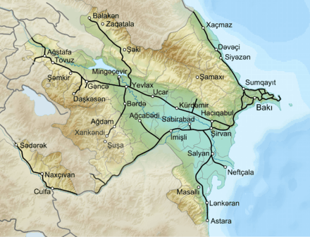
There are 2,932 km (1,822 mi) of rail tracks out of which only 2,117 km (1,315 mi) are in common carrier service and 810 km (500 mi) are industrial lines.[2]
Total: 2,932 km (1,822 mi) (2013)
Country comparison to the world: 59
Broad gauge: 1,520 mm (4 ft 11 27⁄32 in) gauge
Railway links with adjacent countries
Timeline
Metro System
Currently the only metro system in Azerbaijan is the Baku Metro, located in Baku, the country's capital. New plans to open metro systems in the most populated and developed cities of Azerbaijan were unveiled. Sumgayit, Nakhchivan and Ganja all plan to have subway systems in the future.[3]
Roadways
There are about 25,000 kilometers of roads in Azerbaijan, serving domestic cargo traffic and giving access to international main highways. Highways are mostly in fair condition and need an upgrade to international standards in a view to accommodate growing transit traffic. Main and rural roads are in poor condition and in urgent need of rehabilitation and maintenance. The total vehicle fleet in Azerbaijan was about 517,000 in 2004, with about 49 private passenger cars per 1,000 inhabitants, which is quite low compared to European benchmarks but rapidly increasing due to the fast economic growth. Road transport accounted for 54% of all freight in 2003, up from about 48% in 1999.
International highways
Main highways carrying international traffic are the Baku-Alat-Ganja-Qazakh-Georgian Border corridor (Azerbaijani section of TRACECA corridor) with a length of 503 km and the so-called North-South Transport Corridor that stretches out from the Russian to the Iranian border along 521 km. Road connections are disrupted with Armenia because of the unresolved conflict regarding the possession of the Nagorno-Karabakh. Travel between mainland and the detached exclave of Nakhichevan is made by air or by road through Iran. Nakhichevan has a 9-kilometre strategic border with Turkey.
Total: 59,142 km
Country comparison to the world: 74
Paved: 29,210 km
Unpaved: 29,931 km (2013)
Pipelines
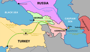
Baku is the centre of a major oil- and gas-producing region, and major long-distance pipelines radiate from the region's oil fields to all neighboring areas. Pipelines are generally high capacity lines and have diameters of either 1,020 or 1,220 millimeters. The main petroleum pipeline was completed in 2005 under American pressure to limit Russian and Iranian influence in the area. It runs from Baku via Tbilisi to Ceyhan in Turkey, therefore the acronym BTC pipeline. It made partly obsolete the old Soviet pipeline pumping crude oil from the onshore and offshore Caspian fields near Baku west across Azerbaijan and Georgia to the port of Batumi, where the oil is either exported in its crude form or processed at Batumi's refinery. Two natural gas lines parallel the old petroleum line as far as Tbilisi, where they turn north across the Caucasus Mountains to join the grid of natural gas pipelines that supply cities throughout Russia and Eastern Europe.
Condensate 89 km; gas 3,890 km; oil 2,446 km (2013)
Ports and harbours
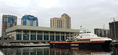
Sea and water cargo transportation have vital importance for Azerbaijan, especially in regions where road and rail connections are disputed. Azerbaijan has direct maritime connections only with other Caspian littoral states (Iran, Kazakhstan, Russia, and Turkmenistan). However, the Volga-Don canal provides a maritime access to the high seas. The main activity is transport of cargo, mainly of oil and oil products. Shipping regions are Caspian, Black, Mediterranean and Marmara Seas. The main shipping company owes 72 ships, 37 of which are tankers (including 1 water-carrier).
Baku International Marine Trade Port is the largest port on the Caspian Sea. Its ferry terminal underwent a major reconstruction supported by a US$16.2 million loan from EBRD. It is now able to handle 30 million tons of freight a year. The Caspian Sea provides vital transport links with other countries and is being used to ship oil until various pipeline projects are completed.
In 2014 Azberbaijan stated it would seek to ease transportation on the Caspian Sea due increased demand by its neighboring states.[4]
On June 4, 2004 the Ministry of Transportation of the Republic of Azerbaijan established the Maritime Administration. As the regulatory authority in maritime transport, its functions include participating in the formulation of state policy, regulating transport demand of goods and passengers and for other types of maritime transport services, as well as implementing state programs, concepts and projects for the development of maritime transport.
Merchant marine
Total: 90 ships
Country comparison to the world: 53
Ships by type: cargo 37, passenger 1, passenger/cargo 8, petroleum tanker 47, chemical tanker 1, roll on/roll off 3, specialized tanker 2
Registered in other countries: 2 (Malta 1, Saint Vincent and the Grenadines 1) (2013)
Airports

There are regular flights between Azerbaijan and former Soviet countries, UK, Germany, France, Austria, Italy, Israel, Iran, Turkey, UAE, United States, China, Georgia and has a cargo flights in UAE, Turkey, Luxembourg, Germany, China, Kyrgyzstan, Afghanistan, and Iraq. The national airline is Azerbaijan Airlines (AZAL). There are 5 international airports located in Baku, Ganja, Nakhchivan, Lenkaran, Zaqatala. Heydar Aliyev International Airport in Baku reopened in 1999 after a US$64 million upgrading and extension financed by Turkish company Enka. The airport can now handle 1,600 passengers an hour. The new runways are also able to serve jumbojets. The complete overhaul of the international airport in Nakhchivan has been completed in May 2004. The US$32 million reconstruction project of Ganja Airport has been launched by the Government and was completed by mid-2006. In 2008, two more airports were opened in Azerbaijan. The Lankaran International Airport is located in southern part of Azerbaijan, Zaqatala Airport is in the north-west of Azerbaijan territory.
Airports: 37 (2008)
Country comparison to the world: 108
Airports - with paved runways
Total: 30
Over 3,047 m: 5
2,438 to 3,047 m: 5
1,524 to 2,437 m: 13
914 to 1,523 m: 4
Under 914 m: 3 (2013)
Airports - with unpaved runways
Total: 7
914 to 1,523 m: 7
Under 914 m: 1 (2013)
Heliports
Total: 1 (2013)
See also
References

- ↑ "World Investment News. V.I.P. Interviews. H.E. Mr. Ziya Mamedov". Retrieved 2010-11-18.
- ↑ "Azerbaijan Railways". Indexmundi. 2009-12-19. Retrieved 2007-11-01.
- ↑ "Good news for Baku Metro's users". azernews. Retrieved 7 January 2015.
- ↑ "Joint venture of Azerbaijan and Turkey to operate transport on Caspian Sea". 12 January 2015. Retrieved 15 January 2015.
External links
| Wikimedia Commons has media related to Transport in Azerbaijan. |

Transport in Asia | |
|---|---|
| Sovereign states |
|
| States with limited recognition |
|
| Dependencies and other territories |
|
| |
Rail transport in Asia | |
|---|---|
| Sovereign states |
|
| States with limited recognition |
|
| Dependencies and other territories | |
| |
| |
| Trams | |
| Trolleybuses | |
| Azerbaijan Railways |
|
| Tourist | |
| Major terminals |
|