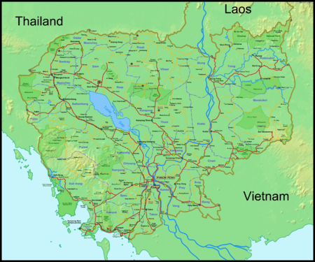
Transport in Cambodia


War and continuing fighting severely damaged Cambodia's transportation system — a system that had been inadequately developed in peacetime. The country's weak infrastructure hindered emergency relief efforts and created tremendous problems of procurement of supplies in general and of distribution. Cambodia received Soviet technical assistance and equipment to support the maintenance of the transportation network.
Road Transport

Highway Network
- Total - 38,257 km (2004)
- Paved - 2,406 km (2004)
- Unpaved - 35,851 km (2004)
Of the current total, only about 50 percent of the roads and highways were covered with asphalt and were in good condition; about 50 percent of the roads were made of crushed stone, gravel, or improved earth; and the remaining approximately 30 percent were unimproved earth or were little more than tracks. In 1981 Cambodia opened a newly repaired section of National Route 1 which runs southeast from Phnom Penh to the Vietnamese border. The road, which suffered damage during the war years, was restored most probably by Vietnamese army engineers.
In the late 1980s, Cambodia's road network was both underutilized and unable to meet even the modest demands placed upon it by an unindustrialized and agrarian society (see fig. 8.). Commercial vehicles, such as trucks and buses, were insufficient in number and lacked the spare parts necessary to keep them running. Road construction and maintenance were ignored by a financially hard-pressed government, while insurgents regularly destroyed bridges and rendered some routes unsafe for travel.
Cambodia is upgrading the main highways to international standards and most are vastly improved from 2006. Most main roads are now paved. And now road construction is on going from the Thailand border at Poipet to Siem Reap (Angkor Wat).
Chart of 01/2014
| National Highway | Code | approx Length | Origin | Terminal | |
|---|---|---|---|---|---|
| National Highway 1 | 10001 | 167.10 km | 103.83 mi | Phnom Penh | Bavet - Vietnam Border |
| National Highway 2 | 10002 | 120.60 km | 74.94 mi | Phnom Penh | Phnom Den - Vietnam Border |
| National Highway 3 | 10003 | 202.00 km | 125.52 mi | Phnom Penh | Kampot - Veal Renh (NH4) |
| National Highway 4 | 10004 | 226.00 km | 140.43 mi | Phnom Penh | Sihanoukville |
| National Highway 5 | 10005 | 341.00 km | 211.89 mi | Phnom Penh | Battambang - Poipet - Thai Border |
| National Highway 6A | 10006A | 76.00 km | 47.22 mi | Phnom Penh | Skuon |
| National Highway 6 | 10006 | 416.00 km | 258.49 mi | Skuon | Siem Reap - Sisophon (NH5) |
| National Highway 7 | 10007 | 509.17 km | 316.38 mi | Skuon | Stung Treng - Laos Border |
| National Highway 8 | 10008 | 105.00 km | 65.24 mi | NH6A - Prek Tamak Bridge | to NH7 near the Vietnam Border. |
Other Public Transport
Motorcycles are by far the most common transport medium in Cambodia. "Cyclo" (as hand-me-down French) or Cycle rickshaws were popular in 1990s but are increasingly replaced by remorques (carriages attached to motorcycles) and rickshaws imported from India. Cyclos are unique to Cambodia in that the cyclist is situated behind the passenger(s) seat, as opposed to Cycle rickshaws in neighbouring countries where the cyclist is at the front and "pulls" the carriage. With 78% mobile phone penetration rate, ride-hailing apps have become popular in recent years, thanks to the market entry of global and regional players such as Uber (no longer available in Cambodia) and Grab (which is currently the dominant player).
Railways
Two rail lines exist, both originating in Phnom Penh and totaling about 612 kilometers of 1,000 mm (3 ft 3 3⁄8 in) metre gauge single track. A third line is planned to connect Phnom Penh with Vietnam, the last missing link of the planned rail corridor between Singapore and the city of Kunming, China. A new north-south line is also planned. The active part of the network is the Phnom Penh-Sihanoukville line, with stops at Takeo and Kampot.
Waterways
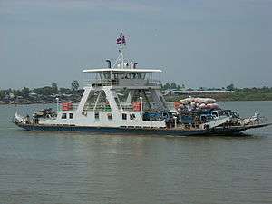
The nation's extensive inland waterways were important historically in domestic trade. The Mekong and the Tonlé Sap Rivers, their numerous tributaries, and the Tonlé Sap provided avenues of considerable length, including 3,700 kilometers navigable all year by craft drawing 0.6 meters and another 282 kilometers navigable to craft drawing 1.8 meters. In some areas, especially west of the Mekong River and north of the Tonle Sap River, the villages were completely dependent on waterways for communications. Launches, junks, or barges transport passengers, rice, and other food in the absence of roads and railways.
According to the Ministry of Communications, Transport, and Posts, Cambodia's main ferry services crossing the Bassac River and the middle Mekong River at Neak Leung Ferry Service, Tonle Bet Ferry Service, Sre Ambel Ferry Service, Kampong Cham Ferry Service, and Stoeng Treng Ferry Service were restored in 1985. The major Mekong River navigation routes also were cleared for traffic. Also seaplane service to all waterways and islands in now offered by Aero Cambodia Airline.
Seaports and harbors
Cambodia has two major ports, Phnom Penh Port and Sihanoukville Port, also known as Kampong Som, and five minor ones. Phnom Penh, located at the junction of the Bassac, the Mekong, and the Tonle Sap rivers, is the only river port capable of receiving 8,000-ton ships during the wet season and 5,000-ton ships during the dry season. It remains an important port for international commerce as well as for domestic communications.
Sihanoukville port reopened in late 1979. It had been built in 1960 with French assistance. In 1980 some 180 Soviet dockworkers, having brought with them forklifts and trucks, were reportedly working at Kampong Som as longshoremen or as instructors of unskilled Cambodian port workers. By 1984 approximately 1,500 Cambodian port workers were handling 2,500 tons of cargo per day. According to official statistics, Sihanoukville had handled only 769,500 tons in the four prior years (1979 to 1983), a level that contrasted sharply with the port's peacetime capacity of about 1 million tons of cargo per year.
Merchant marine
- total - 626 ships (1,000 gross register tons (GRT) or over) totaling 953,105 GRT/1,345,766 tonnes deadweight (DWT)
- ships by type - bulk carrier 41, cargo 530, carrier 3, chemical tanker 10, container ship 8, passenger ship/cargo 6, petroleum tanker 11, refrigerated cargo 15, roll-on/roll-off 1, vehicle carrier 1 (2008)
- note - 467 foreign-owned: Canada 2, China 193, Cyprus 7, Egypt 13, Gabon 1, Greece 3, Hong Kong 8, Indonesia 22, Japan 1, South Korea 22, Latvia 1, Lebanon 8, Netherlands 1, Romania 1, Russia 83, Singapore 4, Syria 48, Taiwan 1, Turkey 26, Ukraine 34, UAE 34, United States 6 (2008)
Airports

The country possesses twenty-six airfields, of which only thirteen were usable in the mid-1980s. Eight airfields had permanent-surface runways. Phnom Penh International Airport in Phnom Penh is the largest airport; it also serves as the main base for the renascent Cambodian Air Force.
Cambodia's second largest airport is Angkor International Airport in the major tourist city of Siem Reap. Tourist traffic into Angkor International Airport saw passenger numbers overtake those of Phnom Penh in 2006, the airport now being the country's busiest.
Cambodia also opened a new Soviet-built airfield at Ream, Sihanoukville International Airport in late 1983, which never saw commercial air traffic until now. There are additional airports in Battambang and Stung Treng.
The new national airline Cambodia Angkor Air was launched in 2009, with a large financial investment from Vietnam Airlines. And Aero Cambodia Airline started business in 2011 offering flights to all airports and water ways with seaplanes.
Airports - with paved runways
Total:
6
2,500 to 3,000 m:
3
1,500 to 2,2500 m:
2
1000 to 1,500 m:
1 (2010)
Airports - with unpaved runways
Total:
11
1,500 to 2,500 m:
1
1000 to 1,500 m:
9
under 1000 m:
1 (2010)
Heliports
1 (2010)
See also
References
![]()
External links
- The SihanoukVille Port
- Cambodians ride 'bamboo railway'
- Video, photos and travel diary of Cambodia's trains by traveller Tom Grundy.
- The Sihanoukville Airport
- National highways
- Inland waterways in Cambodia
- Buses in Cambodia
- SihanoukVille Train Station
Transport in Asia | |
|---|---|
| Sovereign states |
|
| States with limited recognition |
|
| Dependencies and other territories |
|
| |