Transport in Bahrain
Transport in Bahrain encompasses road transportation by car, air transportation and shipping. It has been announced that a monorail network will be constructed.[1] Bahrain has one of the lowest gasoline prices in the world, at $0.78 per gallon ($0.21 per liter).[2]
Road transport
The widening of roads in the old districts of Manama and the development of a national network linking the capital to other settlements commenced as early as the arrival of the first car in 1914.[3] The continuous increase in the number of cars from 395 in 1944,[3] to 3,379 in 1954 and to 18,372 cars in 1970[3] caused urban development to primarily focus on expanding the road network, widening carriageways and the establishment of more parking spaces.[3] Many tracks previously laid in the pre-oil era (prior to the 1930s) were resurfaced and widened, turning them into 'road arteries'. Initial widening of the roads started in the Manama Souq district, widening its main roads by demolishing encroaching houses.[3]
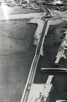
A series of ring roads were constructed (Isa al Kabeer avenue in the 1930s, Exhibition avenue in the 1960s and Al Fateh highway in the 1980s[3]), to push back the coastline and extend the city area in belt-like forms.[3] To the north, the foreshore used to be around Government Avenue in the 1920s but it shifted to a new road, King Faisal Road, in the early 1930s which became the coastal road.[3] To the east, a bridge connected Manama to Muharraq since 1929, a new causeway was built in 1941 which replaced the old wooden bridge.[3] Transits between the two islands peaked after the construction of the Bahrain International Airport in 1932.[3]
To the south of Manama, roads connected groves, lagoons and marshes of Hoora, Adliya, Gudaibiya and Juffair.[3] Villages such as Mahooz, Ghuraifa, Seqaya served as the end of these roads. To the west, a major highway was built that linked Manama to the isolated village port of Budaiya,[3] this highway crossed through the 'green belt' villages of Sanabis, Jidhafs and Duraz.[3] To the south, a road was built that connected Manama to Riffa. The discovery of oil accelerated the growth of the city's road network.[3]
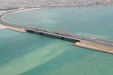
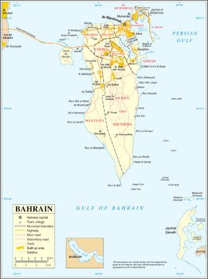
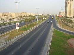
The four main islands and all the towns and villages are linked by well-constructed roads. There were 3,164 km (1,966 mi) of roadways in 2002, of which 2,433 km (1,512 mi) were paved. Multiple causeways stretching over 2.8 km (2 mi), connect Manama with Muharraq Island, and the Sitra Causeway joins Sitra to the main island. A four-lane highway atop a 24 km (15 mi) causeway, linking Bahrain with the Saudi Arabian mainland via the island of Umm an-Nasan was completed in December, 1986, and financed by Saudi Arabia. In 2000, there were 172,684 passenger vehicles and 41,820 commercial vehicles.
Bahrain's port of Mina Salman can accommodate 16 oceangoing vessels drawing up to 11 m (36 ft). In 2001, Bahrain had a merchant fleet of eight ships of 1,000 GRT or over, totaling 270,784 GRT. Private vehicles and taxis are the primary means of transportation in the city.
Bahrain changed from driving on the left to driving on the right in November 1967.[4]
| Road | Distance | Year estimated |
| Paved | 2,768 km (1,720 mi) | 1920 |
| Unpaved | 730 km (454 mi) | 1920 |
| Total | 3,498 km (2,174 mi) | 1920 |

International highways
- King Fahd Causeway, measuring 25 km (16 mi) connects Bahrain and Saudi Arabia through a multiple-dike bridge.
- Qatar–Bahrain Friendship Bridge, will be 45 km (28 mi) long, connecting Bahrain and Qatar as the longest fixed link in the world, consisting both roads and railway.
Railways
As of 2012, there were no railways in Bahrain, but plans were developing for a railway system connecting all the countries in the Persian Gulf[5] and for a light rail network within Bahrain.[6] A subway system has also been proposed.[7] In August 2018, Al-Ayam reported that transportation officials in Bahrain were looking for "bids to fund a new metro railway system in the fourth quarter of 2019." There were plans for the rail to be international, connecting to local railway systems in the UAE and Saudi Arabia. According to Ehsan Bayat, Bahrain's system will contribute 36 km to the network. The project is to be completed in four phases over four years and cost $1-2 billion, as a joint venture between the public and private sector. It will be a 109 km railway system, and the first in Bahrain.[8] It will be called the GCC Railway, linking all six Gulf States. Along with private funders, it will be funded by the Ministry of Transportation in KSA and King Fahad Causeway Authority.[9]
Monorail
Plans are now back on track for construction of a monorail, which would run throughout the island state. Bahrain's Cabinet initially approved the monorail plan in the noughts, though the Global Financial Crisis has delayed the project.[10]
Airports
On a 2014 estimate, Bahrain owns two airports. Among them is Bahrain International Airport, the primary airport in the country.
| Airport | Paved distance (estimated) | Year estimated |
| Bahrain International Airport | 3,962 m (12,999 ft) | 1932 |
| Isa Air Base | 3,780 m (12,402 ft) | 1970 |
Ports and harbors
As of 2008, Bahrain owns three harbors in Manama, Mina Salman and Sitrah.
Pipelines
| Element | Pipeline distance | Year estimated |
| Crude oil | 52 km (32 mi) | 2007 |
| Natural gas | 20 km (12 mi) | 2007 |
Merchant marine
| Statistics for the shipping industry of Bahrain | |||||
|---|---|---|---|---|---|
| Total: 9 ships (1,000 gross register tons (GRT) or over) | |||||
| Totalling: 465,937 GRT/413,393 tonnes deadweight (DWT) | |||||
| Cargo ships | |||||
| Barge carrier | 4 | ||||
| Container ships | 4 | ||||
| Tankers | |||||
| Petroleum tanker ships | 1 | ||||
| Passenger ships | |||||
| |||||
| Source: This article contains material from the CIA World Factbook which, as a US government publication, is in the public domain. | |||||
References
- Much of the material in this article is adapted from the CIA World Factbook 2008.
- ↑ "Bahrain monorail work could start in 2010". Arabian Business. Retrieved 23 June 2012.
- ↑ http://www.csmonitor.com/World/Americas/2011/0913/World-s-cheapest-gas-Top-5-countries/Bahrain-0.78-per-gallon-0.21-per-liter
- 1 2 3 4 5 6 7 8 9 10 11 12 13 14 Elsheshtawy, Yasser. The evolving Arab city: tradition, modernity and urban development. Routledge. p. 198. ISBN 1134128215.
- ↑ Bahrain Government Annual Reports, Times of India Press, 1968, page 158
- ↑ Railway Gazette International January 2009 p21 with Map
- ↑ "Bahrain awaits budget approval for light rail study". Retrieved 2011-02-20.
- ↑ "Subway railway system planned for Bahrain - Bahrain News Manama". Retrieved 2011-02-20.
- ↑ https://ameinfo.com/transportation/what-a-metro-could-mean-for-bahrains-future/
- ↑ http://www.transportation.gov.bh/content/gcc-railway
- ↑ http://www.tradearabia.com/news/CONS_291989.html
External links
Transport in Asia | |
|---|---|
| Sovereign states |
|
| States with limited recognition |
|
| Dependencies and other territories |
|
| |