Tamenglong district
| Tamenglong district | |
|---|---|
| district | |
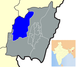 Location of Tamenglong district in Manipur | |
| Coordinates: 24°59′N 93°29′E / 24.983°N 93.483°ECoordinates: 24°59′N 93°29′E / 24.983°N 93.483°E | |
| Country |
|
| State | Manipur |
| Headquarters | Tamenglong |
| Area | |
| • Total | 4,391 km2 (1,695 sq mi) |
| Population (2011) | |
| • Total | 140,143 |
| • Density | 32/km2 (83/sq mi) |
| Languages Manipuri | |
| • Dominating | Zeliangrong (Naga) |
| Time zone | UTC+5:30 (IST) |
| ISO 3166 code | IN-MN-TA |
| Website |
tamenglong |
Tamenglong district (Pron:/tæmɛŋˈlɒŋ/) is one of the districts of Manipur state in northeastern India.[1]
History
In 1919, the British Government established four sub-divisions office in Manipur Hills known as North East Sub-Division, North West Sub-Division, South East Sub-Division and South West Sub-Division. The Head Quarters of North West Sub-Division was set up at Khunjao, Tamenglong Village (Nriangluang) and Mr. William Shaw was appointed as the Sub-Divisional Officer. In 1923, the head quarters of Northwest sub-division was shifted to the present site known as Tamenglong headquarters some 3 km away from Khunjao. Later the Manipur North West sub-division was renamed as Tamenglong Sub-Division. Tamenglong became a full-fledged district in 1969 and the first Deputy Commissioner was posted.
Geography
This district is bounded by Nagaland state on the north, by Senapati district on the north and east, by Churchandpur district on the south and by Imphal West district and Assam state on the west. Tamenglong town is the headquarters of this district. The district occupies an area of 4391 km.
Economy
In 2006 the Ministry of Panchayati Raj named Tamenglong one of the country's 250 most backward districts (out of a total of 640).[2] It is one of the three districts in Manipur currently receiving funds from the Backward Regions Grant Fund Programme (BRGF).[2]
Administrative divisions
The district is divided into 3 sub-divisions:
- Tamenglong
- Tamei
- Tousem
Recently, Noney District was carved out from Tamenglong district; comprising sub-divisions of Longmei (Noney), Nungba, Khoupum, and Haochong.
Khoupum, a small town falling under the Nungba sub division is one of the most populated area within the district and the home town of Hon'ble MLA and former Deputy Chief Minister Shri. Gaikhangam Gangmei.
Demographics
According to the 2011 census Tamenglong district has a population of 140,651,[1] roughly equal to the nation of Saint Lucia.[3] This gives it a ranking of 607th in India (out of a total of 640). The district has a population density of 32 inhabitants per square kilometre (83/sq mi). Its population growth rate over the decade 2001-2011 was 25.69%. Tamenglong has a sex ratio of 953 females for every 1000 males, and a literacy rate of 70.4%.
Languages
Sino-Tibetan languages spoken in Tamenglong district include: Zeliangrong Language/dialect-
- Zeme language
- Liangmai Language
- Rongmei Language
- Inpui language
All the four Language/dialect mentioned above are very much similar and can be understood easily by one another.
References
- 1 2 "Tamenglong". 2011 Census of India. Government of India. Archived from the original on 14 September 2017. Retrieved 14 September 2017.
- 1 2 Ministry of Panchayati Raj (September 8, 2009). "A Note on the Backward Regions Grant Fund Programme" (PDF). National Institute of Rural Development. Archived from the original (PDF) on April 5, 2012. Retrieved September 27, 2011.
- ↑ US Directorate of Intelligence. "Country Comparison:Population". Retrieved 2011-10-01.
Saint Lucia 161,557 July 2011 est.
External links
Places adjacent to Tamenglong district | ||||||||||
|---|---|---|---|---|---|---|---|---|---|---|
| ||||||||||