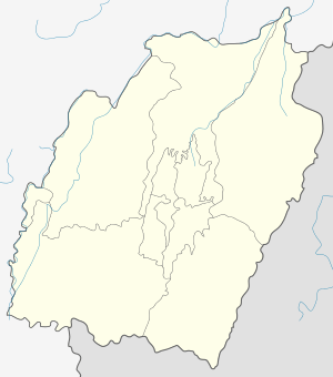
Tamenglong
| Tamenglong Inriangluang | |
|---|---|
| Town | |
 | |
 Tamenglong Location in Manipur, India  Tamenglong Tamenglong (India) | |
| Coordinates: 24°59′26.39″N 93°30′3.26″E / 24.9906639°N 93.5009056°ECoordinates: 24°59′26.39″N 93°30′3.26″E / 24.9906639°N 93.5009056°E | |
| Country |
|
| State | Manipur |
| District | Tamenglong |
| Elevation | 1,061 m (3,481 ft) |
| Population (2011) | |
| • Total | 140,651 |
| Languages | |
| • Spoken | Rongmei, Liangmai, Zeme |
| Time zone | UTC+5:30 (IST) |
| PIN | 795141 |
| Telephone code | 03877 |
| Vehicle registration | MN |
| Literacy | 70.40% |
| Website | Official website |
Tamenglong is an Indian town and the district headquarters of the Tamenglong district. It is located in the state of Manipur. The town is inhabited by the people of the Zeliangrong community. The Rongmei language is spoken in the town and surrounding area.
Geography
Tamenglong is located in western Manipur lying on the hilltop from which descends the Barak River. It is 160 km west of Imphal, Manipur's capital city. The town is surrounded by the following districts: Senapati District to the East, North Cashar Hills District of Assam to the West, Peren District Of Nagaland to the North and Churachanpur of Manipur to the South.
Tamenglong District
Tamenglong District contains virgin forests, exotic orchids, rare and endangered plants, and wildlife. The forests contain tropical evergreen forests, subtropical forests and bamboo brakes. The dense tropical evergreen forests are located along the riversides across the district. Tamenglong is called the Land of the Hornbill as the , Great Pied Hornbill and Indian Pied Hornbill species are found here. Wildflowers include several types of orchids, including epiphytic, lithophytic and terrestrial.
Places of interest
Tamenglong district of Manipur has a topography of irregular undulation with turbulent rivers, waterfalls, caves, lakes, and dense tropical forests covering the land.
- Along the river Barak there is a series of seven waterfalls.
- The Tharon cave (Chalem-Ky) is located at about 27 km from the district HQ. The map of the entire cave is engraved and painted on a stone at the main entrance. Archeological excavation of the cave shows connections to the Hoabinhian culture of North Vietnam.
- Zeilad lake at Makoi (Atengba) is associated with a number of pythons, fishes, and water birds. There are several other lakes nearby including Guiphop Zei, Nrou Zei, and Nap-sam Zei.
- Buning Meadow (Npiulong) is located on the western side of Tamei town. A number of well-groomed uneven small mounds as well numerous brooks mark the stretch. In early summer ground orchids and Wild Lilies can be seen in the meadow. The meadow is also home to wild birds and foxes.
- Phelong Village is well known for its Orange production and its taste. Phelong has been one of the major producers of oranges in Tamenglong District.
- Taningjam Village is one of the oldest villages of Tamenglong District. The rivers and Rock Garden are well-known attractions for a visit to the village.
Main tribes (inhabitants)
- Rongmei Naga
- Zeme Naga
- Liangmai Naga
- Npui Naga
Climate
Köppen-Geiger climate classification system classifies its climate as humid subtropical (Cwa). Tamenglong is a highland which makes the temperatures cooler. The warmer months are extremely rainy. July receives most rain while December is the driest.
| Climate data for Tamenglong | |||||||||||||
|---|---|---|---|---|---|---|---|---|---|---|---|---|---|
| Month | Jan | Feb | Mar | Apr | May | Jun | Jul | Aug | Sep | Oct | Nov | Dec | Year |
| Average high °C (°F) | 18.6 (65.5) |
20 (68) |
23.8 (74.8) |
25.8 (78.4) |
25.9 (78.6) |
25.5 (77.9) |
25.4 (77.7) |
25.5 (77.9) |
25.1 (77.2) |
24.2 (75.6) |
23.6 (74.5) |
19.2 (66.6) |
23.5 (74.4) |
| Daily mean °C (°F) | 12.2 (54) |
13.8 (56.8) |
17.5 (63.5) |
20.1 (68.2) |
21.2 (70.2) |
21.9 (71.4) |
22.1 (71.8) |
22.2 (72) |
21.6 (70.9) |
19.9 (67.8) |
16.2 (61.2) |
13.1 (55.6) |
18.5 (65.3) |
| Average low °C (°F) | 5.9 (42.6) |
7.7 (45.9) |
11.2 (52.2) |
14.4 (57.9) |
16.5 (61.7) |
18.4 (65.1) |
18.9 (66) |
18.9 (66) |
18.1 (64.6) |
15.7 (60.3) |
10.9 (51.6) |
7.1 (44.8) |
13.6 (56.6) |
| Average precipitation mm (inches) | 34 (1.34) |
46 (1.81) |
168 (6.61) |
223 (8.78) |
324 (12.76) |
688 (27.09) |
728 (28.66) |
535 (21.06) |
323 (12.72) |
217 (8.54) |
42 (1.65) |
8 (0.31) |
3,336 (131.33) |
| Source: Climate-Data.org (altitude: 1266m)[1] | |||||||||||||
Gallery
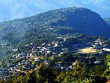
 View of town as seen from Gaidai foothill
 The school goers hideout fame Farmland Lake.
 Raengon Bamduan
 Prayer Mountain
 Nriangluang
 Rah Nouh Bung (Ghost Breasts) at Barak
 Asha Naaploih (Asha Rice Pot) at Barak
 The famous Kacha Khou (Mountain) at Magulong
References
- ↑ "Tamenglong - Climate graph, Temperature graph, Climate table". Climate-Data.org. Retrieved 2016-01-04.
External links
| Wikimedia Commons has media related to Tamenglong. |