Tamborine Mountain
| Tamborine Mountain | |
|---|---|
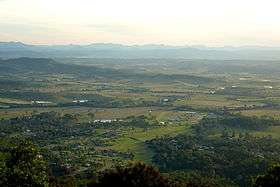 Tamborine Mountain landscape | |
| Highest point | |
| Elevation | 525 m (1,722 ft) |
| Geography | |
| Location | Queensland, Australia |
| Parent range | Great Dividing Range |
| Geology | |
| Age of rock | Aquitanian |
| Mountain type | Shield volcano |
| Tamborine Mountain Queensland | |||||||||||||||
|---|---|---|---|---|---|---|---|---|---|---|---|---|---|---|---|
 Tamborine Mountain | |||||||||||||||
| Coordinates | 27°58′10″S 153°11′57″E / 27.96944°S 153.19917°ECoordinates: 27°58′10″S 153°11′57″E / 27.96944°S 153.19917°E | ||||||||||||||
| Population | 7,030 (2011 census)[1] | ||||||||||||||
| Postcode(s) | 4272 | ||||||||||||||
| LGA(s) | Scenic Rim Region | ||||||||||||||
| State electorate(s) | Scenic Rim | ||||||||||||||
| Federal Division(s) | Wright | ||||||||||||||
| |||||||||||||||
Tamborine Mountain is a 28 km2 (11 sq mi) plateau (8 km long by 4 km wide) and locality in the Scenic Rim local government area of South East Queensland, Australia.[2][3] In the 2011 census, Tamborine Mountain had a population of 7,030 people.[1] The name is of Aboriginal origin and has nothing to do with the musical instrument. It is considered part of the Gold Coast hinterland and has a strong tourist industry.
History
Tamborine Mountain was inhabited by Aborigines for tens of thousands of years and, at the time of early European settlement, lay in the territory of the Wangerriburras. The origin of the name Tamborine comes from the Anglicised version of the Aboriginal word 'Jambreen' from the Yugambeh language.[4] The spelling also appears on early records as Tchambreem and even Goombireen,[4] which means 'wild lime' and refers to the finger lime trees growing on the mountain.
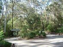
Until it was opened for selection in 1878[5] it was covered with a diverse range of forest types.[4] In that year the first white settler, John O'Callaghan selected a parcel of land on the mountain.[6] Much clearing for agriculture took place, though efforts were made to protect the natural values of the area, with Witches Falls National Park (now part of the Tamborine National Park) being declared in 1908, the first in Queensland.[4] The Tamborine National Park is made up of 12 separate sections of land, mainly remnant rainforest, on the plateau and surrounding foothills. A tourist road to the mountain was opened in 1924.[6]
Heritage listings
Tamborine Mountain has a number of heritage-listed sites, including:
Environment
Geology
The geological origin of the plateau is a lava flow from the Mount Warning volcanic eruption 22 million years ago. Tamborine Mountain rises at the start of the north-east section of the Scenic Rim, the name given to a group of mountains in South East Queensland.
Climate
The climate is a subtropical highland climate (Cwc, according to the Köppen climate classification), with the annual rainfall of about 1,550 mm[5] falling mainly between December and March. Temperatures vary between maxima of 17 °C in winter and 25 °C in summer, and are usually 5 °C to 7 °C degrees cooler than the surrounding lowlands. Winters are usually dry and sunny, with cool maximum temperatures, however the temperature rarely drops below freezing due to the thick forest cover. With its fertile red volcanic soil and high rainfall, the plateau produces rich crops of avocados, kiwifruit, passionfruit, rhubarb, apples and mangoes. With its cool climate and spectacular scenery, as well as its proximity to Brisbane, the Gold Coast and Surfers Paradise, it is a major tourist destination. The Mountain receives an average of 102.9 clear days, annually.[9]
| Climate data for Mt Tamborine | |||||||||||||
|---|---|---|---|---|---|---|---|---|---|---|---|---|---|
| Month | Jan | Feb | Mar | Apr | May | Jun | Jul | Aug | Sep | Oct | Nov | Dec | Year |
| Record high °C (°F) | 35.7 (96.3) |
35.3 (95.5) |
34.9 (94.8) |
31.4 (88.5) |
27.4 (81.3) |
26.6 (79.9) |
25.4 (77.7) |
24.9 (76.8) |
29.6 (85.3) |
35.8 (96.4) |
37.8 (100) |
37.8 (100) |
37.8 (100) |
| Average high °C (°F) | 25.7 (78.3) |
25.3 (77.5) |
24.4 (75.9) |
22.6 (72.7) |
19.8 (67.6) |
17.7 (63.9) |
17.1 (62.8) |
18.3 (64.9) |
20.3 (68.5) |
22.6 (72.7) |
24.6 (76.3) |
25.9 (78.6) |
22.0 (71.6) |
| Average low °C (°F) | 17.1 (62.8) |
17.3 (63.1) |
16.4 (61.5) |
14.0 (57.2) |
11.2 (52.2) |
9.1 (48.4) |
8.0 (46.4) |
8.6 (47.5) |
10.4 (50.7) |
12.8 (55) |
14.8 (58.6) |
16.3 (61.3) |
13.0 (55.4) |
| Record low °C (°F) | 11.7 (53.1) |
10.3 (50.5) |
6.9 (44.4) |
7.6 (45.7) |
3.8 (38.8) |
−0.6 (30.9) |
1.4 (34.5) |
−1.1 (30) |
−0.3 (31.5) |
4.7 (40.5) |
8.3 (46.9) |
9.6 (49.3) |
−1.1 (30) |
| Average rainfall mm (inches) | 224.6 (8.843) |
223.6 (8.803) |
190.1 (7.484) |
131.2 (5.165) |
122.5 (4.823) |
98.8 (3.89) |
82.2 (3.236) |
55.8 (2.197) |
57.1 (2.248) |
91.1 (3.587) |
120.9 (4.76) |
165.2 (6.504) |
1,563.1 (61.54) |
| Average rainy days (≥ 0.2mm) | 14.8 | 15.0 | 15.9 | 12.2 | 10.9 | 9.0 | 8.5 | 7.5 | 8.3 | 10.0 | 12.0 | 13.1 | 137.2 |
| Source: Bureau of Meteorology[9] | |||||||||||||
Important Bird Area
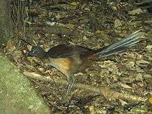
Parts of the plateau and surrounding foothills encompassing the wet subtropical rainforest habitats below the largely cleared plateau summit, and above the surrounding eucalypt forests, have been identified as a 38 km2 (15 sq mi) Important Bird Area (IBA) by BirdLife International. It includes the southern fragments of the Tamborine National Park. The IBA supports an isolated northern population of Albert's lyrebirds, as well as pale-yellow robins, green catbirds, regent bowerbirds and Australian logrunners.[10] Additional significant birds recorded from the site are glossy black cockatoos, sooty owls, marbled frogmouths and noisy pittas. Other animals present in the IBA include platypuses, short-beaked echidnas and Richmond birdwings.[11]
Geography
_Dec_2013.jpg)
Human settlement on the plateau is centred on three village communities: North Tamborine, Eagle Heights and Mount Tamborine, with a total population of about 5,100.[5] The plateau is classified as a rural area, with zoning restrictions that prohibit property from being subdivided. There is no reticulated water supply or sewerage system, and residents are dependent on rainwater, bores and septic systems. Many residents commute to work on the Gold Coast or in Brisbane.
Tourism
Tamborine Mountain attracts many tourists to "Gallery Walk" along Long Road, a street devoted to art galleries, cafes and souvenir shops.[5] Other tourism-heavy areas include Main Street, two one-way roads with cafes, library, fuel, hardware stores, newsagent, the Zamia Theatre, various other shops, and the Tamborine Showground Markets, held every second Sunday of the month. A new major shopping precinct contains more of the above, and a SupaIGA supermarket.
The Glow-Worm Caves are a man-made attraction which opened to visitors in March 2006.[12] They are located in one of the many wineries on the mountain. There are several fine dining locations.
Walking tracks
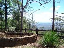
Tamborine Mountain is well known for walking tracks winding through rainforest regions and occasionally past cliffs or waterfalls. The most well-known ones are the Curtis Falls rainforest track and the Knoll. The Palm Grove walk is a 30-minute downhill trek to a massive fallen fig tree (blown down by storms in 2013) through a vast skyline filled with 30-metre (98 ft) tall palms. The track passes mountain streams, a waterfall and wildlife. The Botanic Gardens are found in Eagle Heights.
Schools
- Tamborine Mountain State High School (Secondary years 7–12)
- Tamborine Mountain College (Primary in 2015 – preps–6, secondary years 7–12)
- Tamborine Mountain State School (primary – year 1 – 7)
- St Bernards State School (primary – year 1 – 7)
Amenities
The Scenic Rim Regional Council operates a public library on the corner of Main Street and Yuulong Road.[13]
See also
References
- 1 2 Australian Bureau of Statistics (31 October 2012). "Tamborine Mountain (SSC)". 2011 Census QuickStats. Retrieved 31 January 2016.

- ↑ "Tamborine Mountain - plateau (entry 33236)". Queensland Place Names. Queensland Government. Retrieved 31 January 2016.
- ↑ "Tamborine Mountain - locality (entry 48962)". Queensland Place Names. Queensland Government. Retrieved 31 January 2016.
- 1 2 3 4 "Tamborine National Park: Nature, culture and history". Department of Environment and Resource Management. 2 December 2010. Archived from the original on 13 April 2010. Retrieved 22 June 2011.
- 1 2 3 4 "Tamborine Mountain". Scenic Rim Regional Council. Archived from the original on 6 October 2011. Retrieved 27 June 2011.
- 1 2 Environmental Protection Agency (Queensland) (2000). Heritage Trails of the Great South East. State of Queensland. p. 14. ISBN 0-7345-1008-X.
- ↑ "Tamborine Mountain Road/Geissmann Drive (entry 602365)". Queensland Heritage Register. Queensland Heritage Council. Retrieved 12 July 2013.
- 1 2 3 4 "Local Heritage Register" (PDF). Scenic Rim Regional Council. Archived (PDF) from the original on 24 September 2015. Retrieved 9 February 2015.
- 1 2 "MT TAMBORINE FERN ST". Climate statistics for Australian locations. Bureau of Meteorology. December 2015. Retrieved 1 December 2015.
- ↑ "IBA: Tamborine Mountain". Birdata. Birds Australia. Archived from the original on 6 July 2011. Retrieved 29 October 2011.
- ↑ BirdLife International. (2011). Important Bird Areas factsheet: Tamborine Mountain. Downloaded from http://www.birdlife.org Archived 10 July 2007 at WebCite on 30 October 2011.
- ↑ Glow Worm Caves – Cedar Creek Estate Winery & Vineyard, Mount Tamborine Archived 19 July 2011 at the Wayback Machine.. Retrieved on 20 July 2011.
- ↑ "Locations and Membership". Scenic Rim Regional Council. Archived from the original on 31 January 2018. Retrieved 31 January 2018.
External links
| Wikimedia Commons has media related to Tamborine Mountain, Queensland. |
| Wikivoyage has a travel guide for Tamborine Mountain. |
- "Tamborine Mountain". Queensland Places. Centre for the Government of Queensland, University of Queensland.
- Discover Tamborine Mountain
- Tamborine Mountain Natural History Association