Lamington, Queensland
| Lamington Queensland | |||||||||||||||
|---|---|---|---|---|---|---|---|---|---|---|---|---|---|---|---|
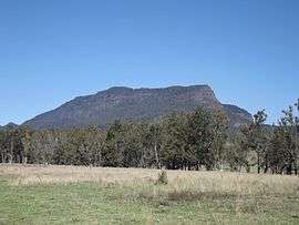 Mount Widgee, 2014 | |||||||||||||||
 Lamington | |||||||||||||||
| Coordinates | 28°15′32″S 153°0′41″E / 28.25889°S 153.01139°ECoordinates: 28°15′32″S 153°0′41″E / 28.25889°S 153.01139°E | ||||||||||||||
| Population | 463 (2011)[1] | ||||||||||||||
| Established | 1997 | ||||||||||||||
| Postcode(s) | 4211 | ||||||||||||||
| LGA(s) | Scenic Rim Region | ||||||||||||||
| State electorate(s) | Scenic Rim | ||||||||||||||
| Federal Division(s) | Wright | ||||||||||||||
| |||||||||||||||
Lamington is a rural locality in the Scenic Rim Region, Queensland, Australia.[2] In the 2011 census, Lamington and surrounding localities had a population of 463 people.[1]
Geography
Christmas Creek is one of a number of tributaries of the Logan River which have headwaters in the McPherson Range along the border. The upper Christmas Creek valley is mountainous. Peaks at Lamington include Little Widgee Mountain, Bujera in the east while across the valley the slopes rise towards Neglected Mountain. The southern boundary follows a section of the western Lamington Plateau and Lamington National Park.
Railway
Lamington was the terminus for one branch of the Beaudesert Shire Tramway. It operated from 1910 to 1944.[3]
References
- 1 2 Australian Bureau of Statistics (31 October 2012). "Innisplain (SSC)". 2011 Census QuickStats. Retrieved 2 April 2016.

- ↑ "Lamington (entry 45158)". Queensland Place Names. Queensland Government. Retrieved 2 April 2016.
- ↑ "Hillview Tramway Station Monument". Monument Australia. Retrieved 30 March 2016.
External links
![]()