Charlwood, Queensland
| Charlwood Queensland | |||||||||||||||
|---|---|---|---|---|---|---|---|---|---|---|---|---|---|---|---|
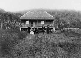 Jensen house, Charlwood, 1898. Pictured are Mr and Mrs Reiner Jensen with sons Peter and Claus, daughter Ida (Mrs Turner) and grandson James Turner. | |||||||||||||||
 Charlwood | |||||||||||||||
| Coordinates | 28°00′39″S 152°34′38″E / 28.01083°S 152.57722°ECoordinates: 28°00′39″S 152°34′38″E / 28.01083°S 152.57722°E | ||||||||||||||
| Population | 415 (2011 census)[1] | ||||||||||||||
| Postcode(s) | 4309 | ||||||||||||||
| Location |
| ||||||||||||||
| LGA(s) | Scenic Rim Region | ||||||||||||||
| State electorate(s) | Scenic Rim | ||||||||||||||
| Federal Division(s) | Wright | ||||||||||||||
| |||||||||||||||
Charlwood is a locality in the Scenic Rim Region, Queensland, Australia.[2] In the 2011 census, Charlwood had a population of 415 people.[1]
Geography
Most of Charlwood is approximately 100-150 metres above sea level and predominantly used for farming and grazing. In the south-west edge of the locality are the lower slopes of Little Mount Edwards. In the eastern edge of the locality are the lower slopes of Mount French. Reynolds Creek flows from Lake Moogerah in the south-west of neighbouring Moogerah through to the north of the locality into Morwincha and Fassifern Valley and ultimately into the Bremer River.[3]
History
The Charlwood Provisional School opened on 20 January 1897. It became Charlwood State School on 1 January 1909. It closed in August 1958.[4]
References
- 1 2 Australian Bureau of Statistics (31 October 2012). "Charlwood (SSC)". 2011 Census QuickStats. Retrieved 17 March 2017.

- ↑ "Charlwood (entry 45126)". Queensland Place Names. Queensland Government. Retrieved 17 March 2017.
- ↑ "Queensland Globe". State of Queensland. Retrieved 17 March 2017.
- ↑ Queensland Family History Society (2010), Queensland schools past and present (Version 1.01 ed.), Queensland Family History Society, ISBN 978-1-921171-26-0
External links
![]()