Kents Lagoon, Queensland
| Kents Lagoon Queensland | |||||||||||||||
|---|---|---|---|---|---|---|---|---|---|---|---|---|---|---|---|
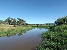 Kents Lagoon, 2015 | |||||||||||||||
 Kents Lagoon | |||||||||||||||
| Coordinates | 27°54′10″S 152°37′44″E / 27.90278°S 152.62889°ECoordinates: 27°54′10″S 152°37′44″E / 27.90278°S 152.62889°E | ||||||||||||||
| Population | 434 (2011)[1] | ||||||||||||||
| Postcode(s) | 4309 | ||||||||||||||
| LGA(s) | Scenic Rim Region | ||||||||||||||
| State electorate(s) | Scenic Rim | ||||||||||||||
| Federal Division(s) | Wright | ||||||||||||||
| |||||||||||||||
Kents Lagoon is a locality in the Scenic Rim Region of Queensland, Australia. At the 2011 Australia Census the locality and surrounds recorded a population of 434.[1]
Geography
In the south east of the locality elevations rise to 140 m at Obum Obum Hill. Warrill Creek marks the western boundary of Kents Lagoon. To the east of Warril Creek lies Kents Lagoon.[2]
History
The lagoon was named by Ludwig Leichhardt after F. Kent, the then owner of Fassifern station.[3] Irrigated farms in the area first went to auction in January 1906.[4]
References
- 1 2 Australian Bureau of Statistics (31 October 2012). "Kents Lagoon (Gazetted Locality)". 2011 Census QuickStats. Retrieved 8 April 2015.

- ↑ "Queensland Globe". State of Queensland. Retrieved 12 March 2017.
- ↑ "Nomenclature Of Queensland.–163". The Courier-Mail. Brisbane: National Library of Australia. 7 April 1936. p. 14. Retrieved 9 April 2015.
- ↑ "Fassifern Estate Queensland". Newspaper clipping. 1906. Retrieved 9 April 2015.
External links
![]()
This article is issued from
Wikipedia.
The text is licensed under Creative Commons - Attribution - Sharealike.
Additional terms may apply for the media files.