Mount Gipps, Queensland
| Mount Gipps Queensland | |||||||||||||||
|---|---|---|---|---|---|---|---|---|---|---|---|---|---|---|---|
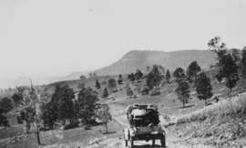 Mount Gipps on McPherson Range, 1928 | |||||||||||||||
 Mount Gipps | |||||||||||||||
| Coordinates | 28°19′20″S 153°00′34″E / 28.32222°S 153.00944°ECoordinates: 28°19′20″S 153°00′34″E / 28.32222°S 153.00944°E | ||||||||||||||
| Postcode(s) | 4285 | ||||||||||||||
| Location |
| ||||||||||||||
| LGA(s) | Scenic Rim Region | ||||||||||||||
| State electorate(s) | Scenic Rim | ||||||||||||||
| Federal Division(s) | Wright | ||||||||||||||
| |||||||||||||||
Mount Gipps is a locality in the Scenic Rim Region, Queensland, Australia.[1] Mount Gipps is one end of the Queensland rabbit-proof fence.[2]
Geography
Mount Gipps has high slopes to the south (including the mountain Mount Gipps) belonging to the McPherson Range and also in the north-east with a valley through the north-west and from west to east. Running Creek, a tributary of the Logan River, flows from east to west through the locality. Mount Gipps Road enters from Chinghee Creek in the north-west and follows through the valley. Although entirely freehold land, only the lower valley areas have been cleared and are used for grazing. The slopes have an extensive tree cover.[3]
History
In 1900, much of the land in the upper reaches of Running Creek was part of the rural property Telemon Crossing owned by A. Drynan.[4]
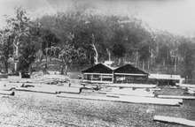
There was a sawmill in Mount Gipps from at least 1920.[5] It was located in the valley.[6]
Mount Gipps State School was opened on 21 July 1920.[7][8] It closed on 30 June 1954.[9][10]
References
- ↑ "Mount Gipps (entry 45173)". Queensland Place Names. Queensland Government. Retrieved 21 August 2015.
- ↑ "Information on the Darling Downs-Moreton Rabbit Board". Darling Downs-Moreton Rabbit Board. 28 January 2015. Archived from the original on 26 February 2015. Retrieved 21 August 2015.
- ↑ "Queensland Globe". State of Queensland. Retrieved 26 August 2015.
- ↑ "From Lara to Cannon and Knapp's Creek". Queensland Country Life. 25 June 1900. p. 18. Retrieved 26 August 2015 – via National Library of Australia.
- ↑ "Meeting at Mount Gipps". The Worker. Brisbane. 25 November 1920. p. 16. Retrieved 26 August 2015 – via National Library of Australia.
- ↑ "AT BEAUDESERT". The Brisbane Courier. 27 June 1922. p. 7. Retrieved 26 August 2015 – via National Library of Australia.
- ↑ "Public Works". The Telegraph. Brisbane. 10 October 1919. p. 4. Retrieved 26 August 2015 – via National Library of Australia.
- ↑ "THE WEEK'S NEWS IN BRIEF". The Week. Brisbane. 4 June 1920. p. 23. Retrieved 26 August 2015 – via National Library of Australia.
- ↑ "Opening and closing dates of Queensland Schools". Queensland Government. Retrieved 26 August 2015.
- ↑ "Agency ID9136, Mount Gipps State School". Queensland State Archives. Retrieved 26 August 2015.
External links
![]()
- "Macpherson Range". The Week. Brisbane. 26 July 1929. p. 8. Retrieved 26 August 2015 – via National Library of Australia. — a description of the MacPherson Ranges in 1929, including Mount Gipps area