Josephville, Queensland
| Josephville Queensland | |||||||||||||||
|---|---|---|---|---|---|---|---|---|---|---|---|---|---|---|---|
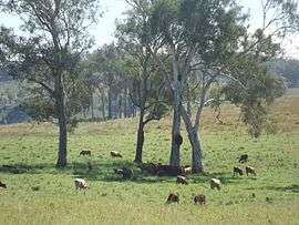 Paddocks along The Hollows Road, 2016 | |||||||||||||||
 Josephville | |||||||||||||||
| Coordinates | 28°0′43″S 152°55′20″E / 28.01194°S 152.92222°ECoordinates: 28°0′43″S 152°55′20″E / 28.01194°S 152.92222°E | ||||||||||||||
| Postcode(s) | 4285 | ||||||||||||||
| LGA(s) | Scenic Rim Region | ||||||||||||||
| State electorate(s) | Scenic Rim | ||||||||||||||
| Federal Division(s) | Wright | ||||||||||||||
| |||||||||||||||
Josephville is a locality in the Scenic Rim Region, Queensland, Australia.[1] At the 2011 Australian Census Josephville and surrounding localities recorded a combined population total of 201.[2] The main land use in the area is agriculture.
Geography
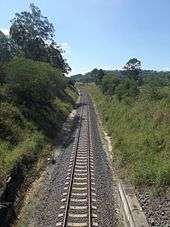
Part of the northern border is marked by the Logan River and its tributary Sandy Creek. A section of the border in the south also follows the Logan River. In the west the land rises to elevations above 500 m above sea level. Both the Mount Lindesay Highway and the Sydney–Brisbane rail corridor pass through Josephville.
History
The Beaudesert Shire Tramway, which operated from 1903 to 1944, had a station here. Josephville was once part of Beaudesert Shire, a former local government area. Josephville State School operated from 1909 to 1935.[3]
References
- ↑ "Josephville - locality (entry 49842)". Queensland Place Names. Queensland Government. Retrieved 26 June 2017.
- ↑ Australian Bureau of Statistics (31 October 2012). "Josephville (State Suburb)". 2011 Census QuickStats. Retrieved 5 September 2014.

- ↑ "Josephville State School". Agency Details. Queensland State Archives. Retrieved 5 September 2014.
External links
![]()