Mount Warning
| Mount Warning | |
|---|---|
| Aboriginal: Wollumbin[1] | |
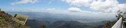 Mount Warning panorama from the summit platform | |
| Highest point | |
| Elevation | 1,159 m (3,802 ft) [2] |
| Prominence | 952 m (3,123 ft) [2] |
| Coordinates | 28°23′50″S 153°16′15″E / 28.39722°S 153.27083°ECoordinates: 28°23′50″S 153°16′15″E / 28.39722°S 153.27083°E [3] |
| Geography | |
 Mount Warning Location in New South Wales, Australia | |
| Location | Northern Rivers, New South Wales, Australia |
| Parent range | Tweed Range |
| Geology | |
| Age of rock | Over 23 million years |
| Mountain type | Volcanic plug |
| Last eruption | ~23 Ma |
| Climbing | |
| Easiest route | Walking track |
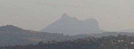
Mount Warning (Aboriginal: Wollumbin[1]), a mountain in the Tweed Range in the Northern Rivers region of New South Wales, Australia, was formed from a volcanic plug of the now-gone Tweed Volcano. The mountain is located 14 kilometres (9 mi) west-south-west of Murwillumbah, near the border between New South Wales and Queensland.[1][3] Lieutenant James Cook saw the mountain from the sea and named it Mount Warning.[3][4]
Shield volcano
Mount Warning is the central volcanic remnant of an ancient shield volcano, the Tweed Volcano, which would have been about 1,900 m (6,200 ft) above sea level or just under twice the height of the current mountain.[5][6] This volcano erupted around 23 million years ago.[7] As the mountain's central vent cooled it shrank, forming a depression at the top that has greatly eroded.[6]
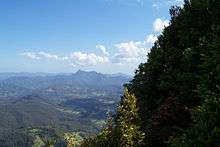

Today the vast areas that were part of the volcano include many mountains and ranges at some distance from Mount Warning, and include the Border Ranges, Tamborine Mountain, the McPherson Range and both the Lamington Plateau and Springbrook Plateaus. The erosion caldera formed since this eruption is easily visible around the summit and forms the rim of the Tweed Valley.
During the last stages of eruption, different and more resistant forms of lava that were cooler than those flows that created the shield volcano remained to form the current peak. The whole central Mount Warning massif was also pushed up by forces that remained active after lava eruptions had stopped.[6]
Aboriginal significance
Wollumbin was removed as the name of the peak NNE of Mt Warning and applied as a dual name to Mt Warning by NSW Geographical names board in 2006. The mountain remains a place of cultural and traditional significance to the Bundjalung people and is a sacred site where particular ceremonies and initiation rites are performed.[3] The Bundjalung people observe cultural and traditional restrictions forbidding the uninitiated from climbing the mountain, and, as such, ask that others also do not attempt to climb the mountain.[8] The government National Parks and Wildlife Service advertise this request and do not encourage climbers to hike the Mt. Warning/Wollumbin Trail up the mountain, but it is not forbidden by park regulations.[9]
Etymology
On 16 May 1770, Lieutenant James Cook was the first European to record seeing "… a remarkable sharp peaked Mountain lying inland…"[4] from a point of land he named Cape Byron. Just five hours later while sailing North, Cook was forced to change course to the East after encountering the dangerous reefs that run 3 miles to the East from Fingal Head, now named Danger Reefs (Inner, South, and Outer reefs).[10]
The next morning, Cook recorded:
"…We now saw the breakers [reefs] again within us which we past at the distance of 1 League [5 km], they lay in the Lat de of 38°..8' [later changed to 28°..8'] & stretch off East two Leagues [10 km] from a point under which is a small Island. There situation may always be found by the peaked mountain before mentioned which bears SWBW from them this and on this account I have named Mount Warning it lies 7 or 8 Leagues [35-40 km] inland in the latitude of 28°..22" S° the land is high and hilly about it but it is conspicuous enough to be distinguished from everything else.[4]
The point off which these shoals lay I have named Point Danger to the northward of it the land which is low trends NWBN but we soon found that it did not keep that direction long before it turned again to the northward."[4]
Protected area
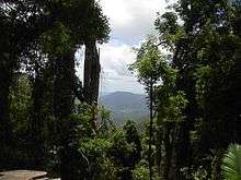
The mountain is now protected by the surrounding Wollumbin National Park, and access is regulated by the New South Wales National Parks and Wildlife Service. Mount Warning is part of the United Nations World Heritage-listed Gondwana Rainforests of Australia.
Walking track
Over 60,000 people a year make the 8.8-kilometre (5.5 mi), five-hour round-trip trek to the top from Breakfast Creek.[11]
An ascent of the mountain takes approximately 1½ to 3½ hours (one way) and requires a good level of fitness. There are also viewing platforms at the summit. The total journey is 8.8 km (5.5 mi).[12]
See also
References
- 1 2 3 "Wollumbin". Geographical Names Register (GNR) of NSW. Geographical Names Board of New South Wales. Retrieved 2009-04-07.
- 1 2 "Mount Warning, Australia". Peakbagger.com. Retrieved 12 May 2015.
- 1 2 3 4 "Mount Warning". Geographical Names Register (GNR) of NSW. Geographical Names Board of New South Wales. Retrieved 2009-04-07.
- 1 2 3 4 "James Cook's Manuscript Daily Journal for 16 May 1770".
- ↑ Johnson, R. Wally; Jan Knutson; Stuart Ross Taylor; Australian Academy of Science (1989). "Eastern Australia Volcanic Geology". Intraplate Volcanism in Eastern Australia and New Zealand. Cambridge University Press. p. 114. ISBN 0521380839. Retrieved 2 June 2012.
- 1 2 3 The Caldera of the Mount Warning Shield Volcano. [brochure] New South Wales National Parks and Wildlife Service. 1990.
- ↑ Knesel, Kurt M.; Cohen, Benjamin E.; Vasconcelos, Paulo M.; Thiede, David S. "Rapid change in drift of the Australian plate records collision with Ontong Java plateau". Nature. 454 (7205): 754–757. doi:10.1038/nature07138.
- ↑ Aboriginal call for crackdown on climbing Mt Warning . Retrieved 30 April 2017
- ↑ Park Brochure Park Brochure. Retrieved on 4 November 2015.
- ↑ Australian Hydrographic Chart "AUS 813"
- ↑ Introducing Mt Warning National Park Archived 3 December 2013 at the Wayback Machine.. Lonely Planet. Retrieved on 17 December 2012.
- ↑ Hema Maps (1997). Discover Australia's National Parks. Milsons Point, New South Wales: Random House Australia. p. 142. ISBN 1-875992-47-2.
External links
| Wikimedia Commons has media related to Mount Warning. |
- UNESCO World Heritage Listing
- Mount Warning National Park
- Mount Warning Map includes driving directions.
- Northern Rivers Geology blog Mount Warning.
- The Caldera of the Tweed Volcano - original source.
![]()