Caloundra
| Caloundra Sunshine Coast, Queensland | |
|---|---|
 Caloundra | |
| Coordinates | 26°48′S 153°08′E / 26.800°S 153.133°ECoordinates: 26°48′S 153°08′E / 26.800°S 153.133°E |
| Population | 41,293 (2006 census)[1] |
| Postcode(s) | 4551 |
| Time zone | AEST (UTC+10:00) |
| Location | 90 km (56 mi) from Brisbane |
| LGA(s) | Sunshine Coast Region |
| State electorate(s) | Caloundra, Kawana |
| Federal Division(s) | Fisher |
Caloundra /kəˈlaʊndrə/ is the southernmost town in the Sunshine Coast Region in South East Queensland, Australia.[2]
Geography
Caloundra is 90 kilometres (55.9 mi) north of the Brisbane central business district. Caloundra is accessible from Landsborough railway station, 21 km away, and the Caloundra bus station.
History
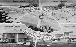
In 1875, Robert Bulcock, an English immigrant who founded a Brisbane newspaper and later represented the Brisbane suburb of Enoggera in the Legislative Assembly of Queensland from 1885 until 1888, bought 277 acres (1.12 km2) of land in the region.[3] A town was surveyed in the 1870s, and land sales commenced in 1883. With its proximity to beaches, the area became popular with tourists and a number of hotels and guest houses were set up to accommodate them.[4]
.jpg)
In 1917, Bulcock's son, Robert Bulcock Jr, who was a councillor in the Shire of Landsborough, subdivided part of the land into 404 lots. This area became known as Bulcock Beach.[3] By 1933, Caloundra had a population of 271.[5]
During World War II, the area became key to Australian defence due to defensive positions along the beaches. Radar stations and machine gun pits were mounted, and Australian and US armed forces came to the area. From the early 1950s onwards, Caloundra experienced a boom in development and population, and by 1968, it had come to dominate the Shire of Landsborough so completely that the council chambers were relocated to Caloundra.[4]

The Caloundra Library opened in 1986 with a major refurbishment in 2017.[6]
Heritage listings
Caloundra has a number of heritage-listed sites, including:
- Bowman Road: Tripcony Hibiscus Caravan Park[7]
- 6 Arthur Street and 3 Canberra Terrace, Kings Beach: Caloundra Lighthouses[8]
- Ormonde Terrace, Kings Beach: Kings Beach Bathing Pavilion[9]
Suburbs
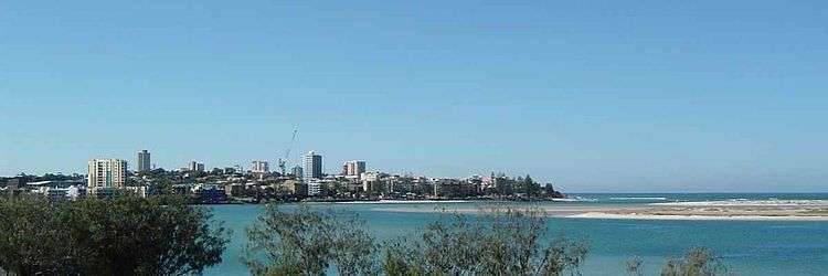
Caloundra is not strictly defined, but the boundary used by the Australian Bureau of Statistics for census purposes and the urban zone defined by the Sunshine Coast Regional Council (formerly the Caloundra City Council) almost exactly coincide. This region is bounded roughly by Currimundi Creek, Rainforest Drive and the Mooloolah River to the north, Beerwah State Forest and Bruce Highway to the west, the Pumicestone Passage (separating the area from Bribie Island) and the ocean to the east, and Bells Creek to the south. The central business district (CBD) for the area is located on Bulcock Street, Caloundra.
The Caloundra urban centre consists of the following suburbs:
Climate
| Climate data for Caloundra, Queensland | |||||||||||||
|---|---|---|---|---|---|---|---|---|---|---|---|---|---|
| Month | Jan | Feb | Mar | Apr | May | Jun | Jul | Aug | Sep | Oct | Nov | Dec | Year |
| Record high °C (°F) | 37.6 (99.7) |
35.2 (95.4) |
33.8 (92.8) |
32.5 (90.5) |
29.6 (85.3) |
26.5 (79.7) |
27.0 (80.6) |
28.4 (83.1) |
33.3 (91.9) |
32.2 (90) |
34.6 (94.3) |
35.5 (95.9) |
37.6 (99.7) |
| Average high °C (°F) | 27.6 (81.7) |
27.2 (81) |
26.4 (79.5) |
24.6 (76.3) |
22.2 (72) |
19.8 (67.6) |
19.3 (66.7) |
20.3 (68.5) |
22.3 (72.1) |
24.1 (75.4) |
25.4 (77.7) |
27.0 (80.6) |
23.8 (74.8) |
| Average low °C (°F) | 21.4 (70.5) |
21.2 (70.2) |
19.9 (67.8) |
17.4 (63.3) |
14.9 (58.8) |
11.7 (53.1) |
10.8 (51.4) |
11.6 (52.9) |
13.9 (57) |
16.5 (61.7) |
18.5 (65.3) |
20.3 (68.5) |
16.5 (61.7) |
| Record low °C (°F) | 15.0 (59) |
15.3 (59.5) |
13.4 (56.1) |
9.3 (48.7) |
6.4 (43.5) |
4.3 (39.7) |
3.3 (37.9) |
5.0 (41) |
6.8 (44.2) |
9.2 (48.6) |
11.7 (53.1) |
12.7 (54.9) |
3.3 (37.9) |
| Average precipitation mm (inches) | 174.0 (6.85) |
202.4 (7.969) |
208.0 (8.189) |
172.9 (6.807) |
170.3 (6.705) |
102.4 (4.031) |
89.2 (3.512) |
60.8 (2.394) |
54.3 (2.138) |
81.1 (3.193) |
113.3 (4.461) |
147.4 (5.803) |
1,578.3 (62.138) |
| Source: Bureau of Meteorology [10] | |||||||||||||
Transport
The region of the Sunshine Coast, including Caloundra, is serviced by the Sunshine Coast Airport, located at Marcoola. A smaller regional airport is also located at Caloundra.
Caloundra's suburbs are served by Sunbus Sunshine Coast, who operate the Caloundra bus station in Cooma Terrace in the CBD. Bus routes 600, 602, 603, 605, 607, 609 connect Caloundra to Kawana Waters, Maroochydore, Buderim and Landsborough.[11]
Landsborough railway station on the Sunshine Coast line has regular services to Roma Street railway station in Brisbane, operated by Queensland Rail. There are several bus companies providing coach services from Caloundra to Brisbane Airport.
Population

Census populations for the Caloundra urban centre have been recorded since 1933. Since the 2001 census, it is divided between the Caloundra North and Caloundra South statistical local areas. The drop between 1981 and 1986 reflects an adjustment of the boundary with the Kawana Waters urban centre.
| Year | Population |
|---|---|
| 1933 | 271 |
| 1947 | 1,718 |
| 1954 | 2,124 |
| 1961 | 2,807 |
| 1966 | 3,657 |
| 1971 | 6,150 |
| 1976 | 10,602 |
| 1981 | 16,758 |
| 1986 | 16,215 |
| 1991 | 22,959 |
| 1996 | 29,096 |
| 2001 | 34,879 |
| 2006 | 41,293 |
| 2011 | 47,762 |
Industry
Tourism


Caloundra has a variety of beaches, providing amenity to the local residents and tourists.
- Golden Beach is protected by Bribie Island to the east, and is used for swimming, windsurfing, boating and fishing. At low tide, Golden Beach and Bribie Island are relatively close.
- Bulcock Beach which is a still water beach, has board-walks, piers and numerous restaurants, and is situated opposite the northern end of Bribie Island. The Des Dywer walking track is an oceanway that starts at Bulcock beach and follows the coastline on cliffs and boardwalks. The walking track ends at Moffat Beach north-east of Bulcock, and is about a one-hour walk. Bulcock Beach is patrolled by volunteer lifesavers from Ithaca–Caloundra City Life Saving Club.
- Kings Beach, named for Allan King who ran a guest house in the area in 1888, is the main beach of Caloundra. Kings is patrolled all year round by Metropolitan – Caloundra Surf Life Saving Club and has a picnic and children's play area. Kings Beach also has a swimming pool which, whilst built to be separate from the ocean, is fed directly from seawater.
- Shelly Beach is not a swimming beach, with the danger of wild rough waves and rocks. However, the northern and southern ends are safer for more advanced or supervised swimmers. Locals often find these places appropriate as, not only is it remote from the crowds of the adjacent King's beach, but local council laws allow dogs on the sand. On low tide, shells and rock pools can be found along the beach. Shelly is surrounded by residential housing with a maximum of five storeys.
- Moffat Beach is not a patrolled beach, but Dicky Beach, located one kilometre north, has a surf lifesaving club and is patrolled year-round. Moffat Beach is surrounded by residential housing, cafes, a post office, a newsagent, parkland and apartments.
- The surf beaches are Kings Beach and Dicky Beach which commence at the eastern end of Bulcock Beach, namely
- Happy Valley (full east/south-east exposure) – Officially Happy Valley is part of and shown on maps as Bulcock Beach.
- Kings Beach (E/SE)
- Shelly Beach(E/NE)
- Moffat Beach (E/NE)
- Dicky Beach (E/NE)
- On Caloundra's outskirts is Aussie World, located at the Glenview turnoff on the Bruce Highway.
- Corbould Park Racetrack – Home of Sunshine Coast Turf Club which holds an important race meet during the Queensland Winter Racing Carnival, with the Group 3 Sunshine Coast Guineas and Listed Caloundra Cup.[12]
Amenities
The Sunshine Coast Regional Council operates a public library at 8 Omrah Avenue.[13]
References
- ↑ Australian Bureau of Statistics (25 October 2007). "Caloundra (C) – Caloundra N. (Statistical Local Area)". 2006 Census QuickStats. Retrieved 21 June 2011.
* Australian Bureau of Statistics (25 October 2007). "Caloundra (C) – Caloundra S. (Statistical Local Area)". 2006 Census QuickStats. Retrieved 21 June 2011. - ↑ "Caloundra - town in Sunshine Coast Region (entry 5784)". Queensland Place Names. Queensland Government. Retrieved 29 June 2017.
- 1 2 "Bulcock Beach's Rich History". Salt Magazine. Spring 2009. Retrieved 21 June 2011.
- 1 2 University of Queensland (2011). "Queensland Places: Caloundra". Retrieved 21 June 2011.
- ↑ Commonwealth Statistician (1934). Census of the Commonwealth of Australia, 30 June 1933: Part VIII, Population and Occupied Dwellings in Localities. p. 14. Retrieved 21 June 2011.
- ↑ "Public Libraries Statistical Bulletin 2016-17" (PDF). Public Libraries Connect. State Library of Queensland. November 2017. p. 15. Archived (PDF) from the original on 30 January 2018. Retrieved 30 January 2018.
- ↑ "Tripcony Hibiscus Caravan Park (entry 602708)". Queensland Heritage Register. Queensland Heritage Council. Retrieved 14 July 2013.
- ↑ "Caloundra Lighthouses (entry 602746)". Queensland Heritage Register. Queensland Heritage Council. Retrieved 14 July 2013.
- ↑ "Kings Beach Bathing Pavilion (entry 601513)". Queensland Heritage Register. Queensland Heritage Council. Retrieved 14 July 2013.
- ↑ "Climate Statistics for Caloundra, Queensland". Retrieved 9 June 2012.
- ↑ Translink Queensland. "All bus timetables". Retrieved 29 July 2017.
- ↑ "Winners and Past Results for the Sunshine Coast Guineas". Races.com (Australia). 2015. Retrieved 12 May 2015.
- ↑ "Caloundra Library". Sunshine Coast Regional Council. Retrieved 30 January 2018.
External links
| Wikivoyage has a travel guide for Caloundra. |

- Caloundra Regional Art Gallery Artabase page
- Caloundra Tourism