Oaky Creek, Queensland
| Oaky Creek Queensland | |||||||||||||||
|---|---|---|---|---|---|---|---|---|---|---|---|---|---|---|---|
 Fields, 2016 | |||||||||||||||
 Oaky Creek | |||||||||||||||
| Coordinates | 28°10′30″S 152°56′06″E / 28.175°S 152.935°ECoordinates: 28°10′30″S 152°56′06″E / 28.175°S 152.935°E | ||||||||||||||
| Population | 463 (2011)[1] | ||||||||||||||
| Established | 1997 | ||||||||||||||
| Postcode(s) | 4285 | ||||||||||||||
| LGA(s) | Scenic Rim Region | ||||||||||||||
| State electorate(s) | Scenic Rim | ||||||||||||||
| Federal Division(s) | Wright | ||||||||||||||
| |||||||||||||||
Oaky Creek is a rural locality in the Scenic Rim Region, Queensland, Australia.[2] In the 2011 census, Oaky Creek and surrounding localities had a population of 463 people.[1]
Geography
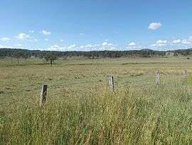
Oaky Creek is a hilly undeveloped area occupying a valley with a single creek flowing into the Logan River. Elevations in the east reach greater than 300 metres above sea level.
References
- 1 2 Australian Bureau of Statistics (31 October 2012). "Innisplain (SSC)". 2011 Census QuickStats. Retrieved 15 March 2016.

- ↑ "Oaky Creek (entry 45178)". Queensland Place Names. Queensland Government. Retrieved 12 March 2016.
External links
![]()
This article is issued from
Wikipedia.
The text is licensed under Creative Commons - Attribution - Sharealike.
Additional terms may apply for the media files.