Knapp Creek, Queensland
| Knapp Creek Queensland | |||||||||||||||
|---|---|---|---|---|---|---|---|---|---|---|---|---|---|---|---|
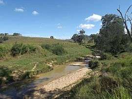 Landscape along Knapp Creek Road, 2016 | |||||||||||||||
 Knapp Creek | |||||||||||||||
| Coordinates | 28°7′S 152°48′E / 28.117°S 152.800°ECoordinates: 28°7′S 152°48′E / 28.117°S 152.800°E | ||||||||||||||
| Population | 59 (2016 census)[1] | ||||||||||||||
| Postcode(s) | 4285 | ||||||||||||||
| LGA(s) | Scenic Rim Region | ||||||||||||||
| State electorate(s) | Scenic Rim | ||||||||||||||
| Federal Division(s) | Wright | ||||||||||||||
| |||||||||||||||
Knapp Creek is a locality in the Scenic Rim Region of South East Queensland, Australia.[2] At the 2011 Australian Census, Knapp Creek and the small town of Rathdowney to the south, recorded a combined population total of 434.[3]
History
The locality is named after Knapps Creek, a tributary of the Logan River.
Geography
In the west is Knapps Peak situated between the Scenic Rim and Teviot Range to the north.
References
- ↑ Australian Bureau of Statistics (27 June 2017). "Knapp Creek (State Suburb)". 2016 Census QuickStats. Retrieved 18 March 2018.

- ↑ "Knapp Creek (entry 45155)". Queensland Place Names. Queensland Government. Retrieved 26 March 2016.
- ↑ Australian Bureau of Statistics (31 October 2012). "Rathdowney". 2011 Census QuickStats. Retrieved 26 March 2016.
External links
![]()
This article is issued from
Wikipedia.
The text is licensed under Creative Commons - Attribution - Sharealike.
Additional terms may apply for the media files.