Allandale, Queensland
| Allandale Queensland | |||||||||||||||
|---|---|---|---|---|---|---|---|---|---|---|---|---|---|---|---|
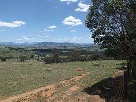 Paddocks and Mount French, 2016 | |||||||||||||||
 Allandale | |||||||||||||||
| Coordinates | 27°57′S 152°44′E / 27.950°S 152.733°ECoordinates: 27°57′S 152°44′E / 27.950°S 152.733°E | ||||||||||||||
| Population | 254 (2011 census)[1] | ||||||||||||||
| Postcode(s) | 4310 | ||||||||||||||
| LGA(s) | Scenic Rim Region | ||||||||||||||
| State electorate(s) | Scenic Rim | ||||||||||||||
| Federal Division(s) | Blair | ||||||||||||||
| |||||||||||||||
Allandale is a locality in the Scenic Rim Region of south-east Queensland, Australia.[2] At the 2011 census, Allandale and the surrounding area had a population of 264.[1]
Geography
There are no major roads in Allandale.
Teviot Brook flows through the north of Allandale. Some of the land is used for agricultural purposes. The southeast portion is hilly, undeveloped and mostly cleared of natural vegetation. This catchment area is separate from the Teviot Brook watershed, with run-off flowing in to Allan Creek, a tributary of the Logan River to the east
References
- 1 2 Australian Bureau of Statistics (31 October 2012). "Allandale (State Suburb)". 2011 Census QuickStats. Retrieved 20 December 2016.

- ↑ "Allandale - locality (entry 45104)". Queensland Place Names. Queensland Government. Retrieved 23 June 2017.
External links
![]()
This article is issued from
Wikipedia.
The text is licensed under Creative Commons - Attribution - Sharealike.
Additional terms may apply for the media files.