Rural Municipality of Coteau No. 255
| Coteau No. 255 | |
|---|---|
| Rural municipality | |
 Coteau No. 255 | |
| Coordinates: 51°08′42″N 107°00′11″W / 51.145°N 107.003°W | |
| Country | Canada |
| Province | Saskatchewan |
| Census division | Census Division 7 |
| Seat | Birsay, Saskatchewan |
| Area | |
| • Total | 899.27 km2 (347.21 sq mi) |
| Population (2006) | |
| • Total | 468 |
| • Density | 0.52/km2 (1.3/sq mi) |
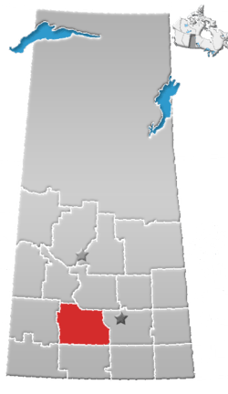
Coteau No. 255 is a rural municipality in the Canadian province of Saskatchewan, located in the Census Division 7. The seat of the municipality is located in the hamlet of Birsay. Its eastern border runs along the shore of Lake Diefenbaker.
Demographics
In 2006, the Rural municipality had a population of 468 in 173 dwellings, a -8.4% decrease from 2001. On a surface of 899.27 km² it has a density of 0.5 inhabitants/km².[1]
Communities
The following communities are located in this municipality:
Resort Villages
Organized Hamlets
Hamlets
- Birsay, seat of municipality
- Dunblane
- Lyons
- Tichfield Junction
- Tullis
Transportation
- Saskatchewan Highway 44
- Saskatchewan Highway 45
- Saskatchewan Highway 373
- Saskatchewan Highway 646
- Big Sky Rail (AGT Foods
- Lucky Lake Airport
Attractions
- Gardiner Dam
- Lucky Lake Heritage Marsh
- Hitchcock's Hideaway Archaeological Field School
- Hitchcock Cabin
- Elbow Harbour Provincial Recreation Site
- Elbow Museum / Mistusinne Cairns
See also
References
- ↑ 2006 Community Profiles Coteau No. 255, Saskatchewan
External links
This article is issued from
Wikipedia.
The text is licensed under Creative Commons - Attribution - Sharealike.
Additional terms may apply for the media files.