Rural Municipality of Prairie Rose No. 309
| Prairie Rose No. 309 | |
|---|---|
| Rural municipality | |
 | |
 Location of Prairie Rose No. 309 in Saskatchewan | |
| Coordinates: 51°45′37″N 104°41′20″W / 51.7603°N 104.689°WCoordinates: 51°45′37″N 104°41′20″W / 51.7603°N 104.689°W | |
| Country | Canada |
| Province | Saskatchewan |
| Rural Municipality | December 12, 1910 |
| Area | |
| • Total | 839.08 km2 (323.97 sq mi) |
| Population (2006) | |
| • Total | 292 |
| • Density | 0.35/km2 (0.90/sq mi) |
| Time zone | UTC-6 (UTC) |
Prairie Rose No. 309 is a rural municipality of 292 rural residents (2006 census) in the central part of Saskatchewan, Canada. The RM was incorporated December 12, 1910.[1] Other localities in the area include the village of Jansen and the hamlet of Esk.[2][3][4]
A rural municipality is an administrative district consisting of an elected reeve, councilors, administrator who provide essential services within their area.
Communities and localities
The following urban municipalities are surrounded by the Rural Municipality of Fertile Valley No. 285:
- none
- none
- Jansen, (seat of municipality)
- none
The following hamlets are located within the Rural Municipality of Fertile Valley No. 285:
- none
- none
- none
- Esk
Statistics
| Canada census – Rural Municipality of Prairie Rose No. 309 community profile | |||
|---|---|---|---|
| 2006 | |||
| Population: | 292 (-15.4% from 2001) | ||
| Land area: | 839.08 km2 (323.97 sq mi) | ||
| Population density: | 0.3/km2 (0.78/sq mi) | ||
| Median age: | N/A (M: N/A, F: N/A) | ||
| Total private dwellings: | 129 | ||
| Median household income: | $Not Available | ||
| References: 2006[5] earlier[6] | |||
Area statistics
References
- ↑ "MRD Municipal Status Information", Ministry of Municipal Affairs, Government of Saskatchewan, archived from the original on 2008-03-25, retrieved 2008-03-28
- ↑ Saskatchewan Genealogy Association, retrieved 2008-03-28
- ↑ Huang, Yj; Powers, R; Montelione, Gt (February 2005), "Statistics", Statistics Canada; Journal of the American Chemical Society, Government of Canada, 127 (6), pp. 1665–74, doi:10.1021/ja047109h, PMID 15701001, retrieved 2008-03-28
- ↑ "Prairie Rose No. 309", Sask biz, Government of Saskatchewan, retrieved 2008-03-28
- ↑ "2006 Community Profiles". Canada 2006 Census. Statistics Canada. March 30, 2011. Retrieved 2009-02-24.
- ↑ "2001 Community Profiles". Canada 2001 Census. Statistics Canada. February 17, 2012.
- ↑ "Prairie Rose No. 309, Saskatchewan, Canada, North America", World Index, Rumbletum.org, 2004, retrieved 2008-03-28
External links
- Saskatoon Regional Economic Development Authority - SREDA
- Saskatchewan, Canada, Rand McNally 1924 Indexed Pocket Map Tourists' and Shippers' Guide
- GeoNames Query
- Post Offices and Postmasters - ArchiviaNet - Library and Archives Canada
- Saskatchewan Gen Web - One Room School Project
- Canadian Maps: January 1925 Waghorn's Guide. Post Offices in Man. Sask. Alta. and West Ontario.
- Saskatoon Gen Web
- Map of Prairie Rose No. 309 at Statcan
| Towns | 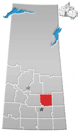 | ||||
|---|---|---|---|---|---|
| Villages | |||||
| Resort villages | |||||
| Rural municipalities | |||||
| Unincorporated communities |
| ||||
This article is issued from
Wikipedia.
The text is licensed under Creative Commons - Attribution - Sharealike.
Additional terms may apply for the media files.