Mortlach, Saskatchewan
| Mortlach | |
|---|---|
| Village | |
| Village of Mortlach | |
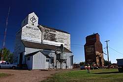 Historic grain elevators in Mortlach. Former Saskatchewan Wheat Pool on right under demolition. | |
| Motto(s): Meet Me In Mortlach | |
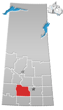
 Location of Mortlach in Saskatchewan  Mortlach, Saskatchewan (Canada) | |
| Coordinates: 50°27′18″N 106°03′50″W / 50.455°N 106.064°W | |
| Country |
|
| Province |
|
| Region | Southwest |
| Census division | 7 |
| Rural Municipality | Wheatlands No. 163 |
| Post office Founded | 1905 |
| Incorporated (Village) | January 1, 1949 |
| Government | |
| • Type | Municipal |
| • Governing body | Mortlach Village Council |
| • Mayor | Dale Domeij |
| • Administrator | Eileen Anderson |
| Area | |
| • Total | 2.76 km2 (1.07 sq mi) |
| Population (2016) | |
| • Total | 261 |
| • Density | 94.5/km2 (245/sq mi) |
| Time zone | UTC-6 (CST) |
| Postal code | S0H 3E0 |
| Area code(s) | 306 |
| Highways |
|
| Railways | Canadian Pacific Railway |
| Website | Village of Mortlach |
| [1][2][3][4] | |
Mortlach is a village within the Rural Municipality of Wheatlands No. 163, in the province of Saskatchewan, Canada. Mortlach had a population of 261 at the 2016 Canada Census. The village is located on the Trans Canada Highway about 40 km west of the city of Moose Jaw. Thunder Creek (one of the rivers that flows into Moose Jaw) passes the town to the north where it is joined by Sandy Creek. Mortlach became a village on April 19, 1906 and is one of two towns in Saskatchewan to have been incorporated as a town (April 1, 1913) to then be reverted to village status on January 1, 1949,[5] the other is the village of Alsask.
Demographics
| Canada census – Mortlach, Saskatchewan community profile | |||
|---|---|---|---|
| 2016 | 2011 | 2006 | |
| Population: | 261 (-9.7% from 2011) | 289 (13.8% from 2006) | 254 (5.4% from 2001) |
| Land area: | 2.76 km2 (1.07 sq mi) | 2.76 km2 (1.07 sq mi) | 2.76 km2 (1.07 sq mi) |
| Population density: | 94.5/km2 (245/sq mi) | 104.7/km2 (271/sq mi) | 92.0/km2 (238/sq mi) |
| Median age: | 44.2 (M: 40.8, F: 48.5) | 44.8 (M: 41.5, F: 45.3) | 45.6 (M: 46.5, F: 44.8) |
| Total private dwellings: | 117 | 129 | 117 |
| Median household income: | |||
| References: 2016[6] 2011[7] 2006[8] earlier[9] | |||
History
Origin of name
While there are several theories about the origin of the name Mortlach such as: it was named after an English Village; it is a Gaelic translation of 'low hills'; and it may be a French term for 'dead lake' or Lac du Mort. The one that is generally accepted is that the Village was named by George Stephen, the first President of the CPR, for his home Parish of Mortlach, Scotland. Other community names such as Parkbeg, Caron and Craigellachie, site of the 'Last Spike', also hail from his home parish. A church in Dufftown in Banffshire, Scotland with origins dating back to 525 AD, bears the Mortlach name.
Homesteading days
_(20333181999).jpg)
In 1904, the Canadian Pacific Railway's (CPR) new line became operational and the Village of Mortlach came to life on land originally homesteaded in 1902 by a Khamis Michael, a native of what is today Iraq. By the spring of 1905, many people who had homesteaded the summer before along with new homesteaders began building. The first store, post office, and lumber and coal supply would be owned by Mr. E.B. Tedford. Scribner and Wheeler built the first hotel in 1905 and the first school was built that fall.
One year later, in 1905, Mortlach already had a Board of Trade with a strong business district including two businesses, three general stores, lumber and coal suppliers, post office, livery, hotel, meat market, and an implement and harness dealer. In the fall of 1905 there was a section house but no station until 1906, built along with an elevator. The first Royal Northwest Mounted Police were stationed here in 1905 the same year that the Province of Saskatchewan was created. These were exciting times. The first weekly Mortlach newspaper was printed in Caron and the Methodist Church was also organized that year. The first doctor came to town that year and Mortlach fast became a popular place to stop and visit. 1907 saw many additional businesses grow, more hardware and implements, dry goods, general stores, harness shops, butchers, tinsmith, livery, real estate and insurance, and a hotel with a restaurant.
1907 was also the year of a Small Pox Epidemic so a new house that was being built became an isolation hospital. The Bank of Hamilton opened a branch on Rose Street and Khamis Michael built a rink on Dean Street. The first exhibition was held in that rink on August 4, 1908. Mortlach incorporated as a Village in 1909 with about 700 residents. The Star Theatre was built in 1910 by A.C. Baker. Soon there were many more businesses in this thriving community: a Red and White Store, two restaurants, blacksmith, grocery store, two cobblers, butcher, baker, undertaker, embalmer, flour miller, electric repair shop, Chinese laundry, veterinarian, Beaver Lumber, Imperial Lumber, Bank of Toronto, photo studio, newspaper publisher, livery stable and auto garage, and another implement shop.
Government
The village is governed by a village council composed of a mayor, four councillors and a village Administrator.[10] Municipal elections are held every three years.
Notable people
- Jack Poole, Vancouver-based businessman (April 14, 1933 - October 23, 2009)
Attractions
Mortlach has a large variety of attractions, including a community orchard, churches, parks and restaurants, a library, museum and beautiful scenery. Music plays a big part in Mortlach's culture - from the Mortlach Old Time Fiddlers to the community choir. A new group, "We Could Be Cousins", had its debut in Mortlach on 4 July 2009. Also in July 2009, Mortlach was awarded an Artist In Residence for a year.[11]
Education
Mortlach has one school that covers Kindergarten through grade 12, that boasts a strong academic record with a mix of sports, cultural, and social aspects.
See also
References
- ↑ National Archives, Archivia Net, Post Offices and Postmasters
- ↑ Government of Saskatchewan, MRD Home, Municipal Directory System, archived from the original on 2012-08-26
- ↑ Canadian Textiles Institute. (2005), CTI Determine your provincial constituency, archived from the original on 2007-09-11
- ↑ Commissioner of Canada Elections, Chief Electoral Officer of Canada (2005), Elections Canada On-line
- ↑ Municipal History - Urban Incorporated Dates
- ↑ "2016 Community Profiles". Canada 2016 Census. Statistics Canada. February 21, 2017. Retrieved 2017-03-15.
- ↑ "2011 Community Profiles". Canada 2011 Census. Statistics Canada. July 5, 2013. Retrieved 2012-10-14.
- ↑ "2006 Community Profiles". Canada 2006 Census. Statistics Canada. March 30, 2011. Retrieved 2010-09-11.
- ↑ "2001 Community Profiles". Canada 2001 Census. Statistics Canada. February 17, 2012.
- ↑ Municipal Affairs Village of Mortlach Retrieved on 2008-01-02
- ↑ Mortlach Website
External links
- Village of Mortlach - Official webpage
- Mortlach Village Council
- 2001 Community Profiles
Places adjacent to Mortlach, Saskatchewan | |
|---|---|
| Subdivisions | |
|---|---|
| Communities | |
| Cities | |
| Topics |
|
| |