Chaplin, Saskatchewan
| Chaplin | |
|---|---|
| Village | |
| Village of Chaplin | |
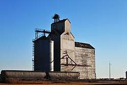 The Former Saskatchewan Wheat Pool grain elevator in Chaplin | |
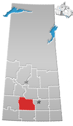
 Chaplin Location of Chaplin in Saskatchewan  Chaplin Chaplin (Canada) | |
| Coordinates: 50°16′23″N 106°23′28″W / 50.273°N 106.391°W | |
| Country |
|
| Province |
|
| Region | Southwest Saskatchewan]] |
| Census division | 7 |
| Rural Municipality | Chaplin No. 164 |
| Government | |
| • Type | Municipal |
| • Governing body | Chaplin Village Council |
| • Mayor | Gary Adrian |
| • Administrator | Raegan Funk |
| Area | |
| • Land | 1.26 km2 (0.49 sq mi) |
| Population (2016) | |
| • Total | 229 |
| • Density | 182.0/km2 (471/sq mi) |
| Time zone | UTC-6 (CST) |
| Postal code | S0H 0V0 |
| Area code(s) | 306 |
| Highways |
|
| Railways | Canadian Pacific Railway |
| Website | Village of Chaplin |
Chaplin is a village within the Rural Municipality of Chaplin No. 164, Saskatchewan, Canada. The village had a population of 229 in the 2016 Census, (a % crease from the __ in the 2011 Census. The community is situated on the Trans-Canada Highway approximately 85 km from Moose Jaw and 90 km from Swift Current. The main industries of Chaplin are Saskatchewan Minerals and farming/ranching. Chaplin consists of eight streets, two crescents, and four avenues (including the avenue on the 'other side of the (train) tracks').
Government
Chaplin is governed by an elected Mayor and five councilors. The village employs a Village Administrator, Village Foreperson, and on Saturdays an additional individual who works at the Village Dump administering public waste disposal (there is also weekly curb-side trash pick-up).
Demographics
| Canada census – Carmichael community profile | |||
|---|---|---|---|
| 2016 | 2011 | 2006 | |
| Population: | 229 (+5.0% from 2011) | 218 (-7.5% from 2006) | 235 (% from 2001) |
| Land area: | 1.72 km2 (0.66 sq mi) | 1.26 km2 (0.49 sq mi) | 1.26 km2 (0.49 sq mi) |
| Population density: | 182.0/km2 (471/sq mi) | 173.2/km2 (449/sq mi) | |
| Median age: | 52.1 (M: 53.0, F: 47.5) | 51.5 (M: 51.6, F: 50.8) | |
| Total private dwellings: | 146 | 138 | |
| Median household income: | $N/A | ||
| References: 2016[1] 2011[2] 2006[3] earlier[4] | |||
Information
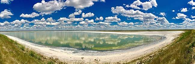
Chaplin Lake & shorebird
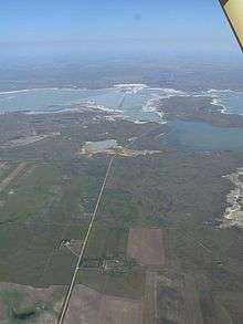
Chaplin is situated on the Trans-Canada Highway between Moose Jaw and Swift Current, and on the north edge of Chaplin Lake. The lake encompasses nearly 20 square miles (52 km2).
Climate
| Climate data for Chaplin | |||||||||||||
|---|---|---|---|---|---|---|---|---|---|---|---|---|---|
| Month | Jan | Feb | Mar | Apr | May | Jun | Jul | Aug | Sep | Oct | Nov | Dec | Year |
| Record high °C (°F) | 11.5 (52.7) |
15 (59) |
23.9 (75) |
32.8 (91) |
36.7 (98.1) |
42.8 (109) |
40.6 (105.1) |
42.8 (109) |
38.9 (102) |
30.6 (87.1) |
22.2 (72) |
17.8 (64) |
42.8 (109) |
| Average high °C (°F) | −8 (18) |
−5.1 (22.8) |
2.3 (36.1) |
11.4 (52.5) |
18.5 (65.3) |
23.2 (73.8) |
25.6 (78.1) |
24.9 (76.8) |
18.4 (65.1) |
11.8 (53.2) |
0.4 (32.7) |
−6.3 (20.7) |
9.8 (49.6) |
| Daily mean °C (°F) | −13 (9) |
−10.1 (13.8) |
−3 (27) |
5 (41) |
11.8 (53.2) |
16.5 (61.7) |
18.8 (65.8) |
17.9 (64.2) |
11.7 (53.1) |
5.5 (41.9) |
−4.5 (23.9) |
−11.3 (11.7) |
3.8 (38.8) |
| Average low °C (°F) | −17.8 (0) |
−15 (5) |
−8.2 (17.2) |
−1.5 (29.3) |
5 (41) |
9.8 (49.6) |
11.9 (53.4) |
10.9 (51.6) |
4.9 (40.8) |
−0.8 (30.6) |
−9.2 (15.4) |
−16.2 (2.8) |
−2.2 (28) |
| Record low °C (°F) | −47.2 (−53) |
−44.4 (−47.9) |
−41.7 (−43.1) |
−26.7 (−16.1) |
−13.9 (7) |
−6.7 (19.9) |
1.1 (34) |
−2.2 (28) |
−12.2 (10) |
−26.1 (−15) |
−40 (−40) |
−40.6 (−41.1) |
−47.2 (−53) |
| Average precipitation mm (inches) | 14 (0.55) |
15.7 (0.618) |
20.2 (0.795) |
19.7 (0.776) |
53.5 (2.106) |
60.4 (2.378) |
62.3 (2.453) |
47.1 (1.854) |
35 (1.38) |
13.6 (0.535) |
11.9 (0.469) |
19.3 (0.76) |
386.3 (15.209) |
| Source: Environment Canada[5] | |||||||||||||
See also
References
- ↑ "2016 Community Profiles". Canada 2016 Census. Statistics Canada. February 21, 2017. Retrieved 2017-03-15.
- ↑ "2011 Community Profiles". Canada 2011 Census. Statistics Canada. July 5, 2013. Retrieved 2012-10-30.
- ↑ "2006 Community Profiles". Canada 2006 Census. Statistics Canada. March 30, 2011. Retrieved 2009-02-24.
- ↑ "2001 Community Profiles". Canada 2001 Census. Statistics Canada. February 17, 2012.
- ↑ Environment Canada Canadian Climate Normals 1971–2000, accessed 24 July 2010
External links
Places adjacent to Chaplin, Saskatchewan | ||||||||||
|---|---|---|---|---|---|---|---|---|---|---|
| ||||||||||
| Subdivisions | |
|---|---|
| Communities | |
| Cities | |
| Topics |
|
| |
Coordinates: 50°27′37.33″N 106°39′17.28″W / 50.4603694°N 106.6548000°W