Dolomites
| Dolomites | |
|---|---|
|
Italian: Dolomiti German: Dolomiten | |
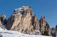
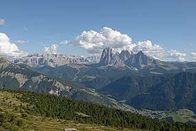 View on the Western Dolomites in Gherdëina | |
| Highest point | |
| Peak | Marmolada |
| Elevation | 3,343 m (10,968 ft) |
| Coordinates | 46°26′N 11°51′E / 46.433°N 11.850°ECoordinates: 46°26′N 11°51′E / 46.433°N 11.850°E |
| Geography | |
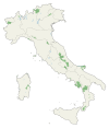
 Dolomites Location of the Dolomites in the Alps | |
| Country | Italy |
| Province | Belluno, South Tyrol and Trentino |
| Parent range | Alps |
| Geology | |
| Orogeny | Alpine orogeny |
| Age of rock | Mostly Triassic |
| Type of rock |
Sedimentary rocks, including dolomite, and volcanics |
| UNESCO World Heritage site | |
| Criteria | Natural: vii, viii |
| Reference | 1237 |
| Inscription | 2009 (33rd Session) |
| Area | 141,902.8 ha |
| Buffer zone | 89,266.7 ha |
The Dolomites (Italian: Dolomiti [doloˈmiːti]; Ladin: Dolomites; German: Dolomiten [doːloːˈmɪtn̩] (![]()
There are also mountain groups of similar geological structure that spread over the River Piave to the east – Dolomiti d'Oltrepiave; and far away over the Adige River to the west – Dolomiti di Brenta (Western Dolomites). There is also another smaller group called Piccole Dolomiti (Little Dolomites) located between the provinces of Trentino, Verona and Vicenza (see map).
The Dolomiti Bellunesi National Park and many other regional parks are located in the Dolomites. In August 2009, the Dolomites were declared a UNESCO World Heritage Site.
Etymology
The Dolomites, also known as the "Pale Mountains", take their name from the carbonate rock dolomite, itself named for 18th-century French mineralogist Déodat Gratet de Dolomieu (1750–1801), who was the first to describe the mineral.[1]
History
During the First World War, the front line between the Italian and Austro-Hungarian forces ran through the Dolomites, where mines were used extensively. There are now open-air war museums at Cinque Torri (Five Towers) and Mount Lagazuoi. Many people visit the Dolomites to climb the vie ferrate, protected paths created during the war.
A number of long-distance footpaths traverse the Dolomites. They are called alte vie (high paths), and are numbered from 1 to 8. The trails take on the order of a week to walk, and are served by numerous rifugi (huts). The first and perhaps most renowned is the Alta Via 1.
Radiocarbon dating has been used in the Alta Badia region to demonstrate a connection between landslide activity and climate change.[2]
Geography
The region is commonly divided into the Western and Eastern Dolomites, separated by a line following the Val Badia – Campolongo Pass – Cordevole Valley (Agordino) axis.
Current classification
The Dolomites may be divided into the following ranges:
|
|
|
Tourism
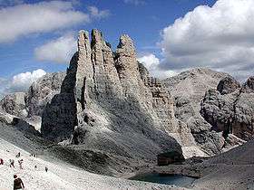
.jpg)
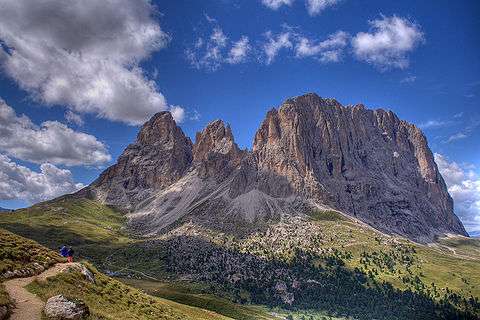
The Dolomites are renowned for skiing in the winter months and mountain climbing, hiking, cycling, and BASE jumping, as well as paragliding and hang gliding in summer and late spring/early autumn. Free climbing has been a tradition in the Dolomites since 1887, when 17-year-old Georg Winkler soloed the first ascent of the pinnacle Die Vajolettürme.[3] The main centres include: Rocca Pietore alongside the Marmolada Glacier, which lies on the border of Trentino and Veneto, the small towns of Alleghe, Falcade, Auronzo, Cortina d'Ampezzo and the villages of Arabba, Urtijëi and San Martino di Castrozza, as well as the whole of the Fassa, Gardena and Badia valleys.
The Maratona dles Dolomites, an annual single-day road bicycle racing race covering seven mountain passes of the Dolomites, occurs in the first week of July.
Other characteristic places are:
- Mount Pasubio and Strada delle 52 Gallerie (a military mule road built during World War I with 52 tunnels)
- Altopiano di Asiago and Calà del Sasso, with 4444 steps, the world's longest staircase open to the public.
Major peaks
| Name | metres | feet | Name | metres | feet |
|---|---|---|---|---|---|
| Marmolada | 3,343 | 10,968 | Pala di San Martino | 2,982 | 9,831 |
| Antelao | 3,264 | 10,706 | Rosengartenspitze / Catinaccio | 2,981 | 9,781 |
| Tofana di Mezzo | 3,241 | 10,633 | Cima di Fradusta | 2,941 | 9,715 |
| Sorapiss | 3,229 | 10,594 | Cimon del Froppa | 2,932 | 9,649 |
| Cristallo | 3,221 | 10,568 | Monte Agnèr | 2,872 | 9,416 |
| Monte Civetta | 3,220 | 10,564 | Fermedaturm | 2,867 | 9,407 |
| Cima di Vezzana | 3,192 | 10,470 | Cima d'Asta | 2,848 | 9,344 |
| Cimon della Pala | 3,184 | 10,453 | Cima di Canali | 2,846 | 9,338 |
| Langkofel / Sassolungo | 3,181 | 10,427 | Croda Grande | 2,839 | 9,315 |
| Monte Pelmo | 3,168 | 10,397 | Vajoletturm / Torri del Vajolet (highest) | 2,821 | 9,256 |
| Dreischusterspitze | 3,162 | 10,375 | Sass Maor | 2,816 | 9,239 |
| Boespitze / Piz Boè (Sella group) | 3,152 | 10,342 | Cima di Ball | 2,783 | 9,131 |
| Hohe Gaisl (Croda Rossa d'Ampezzo) | 3,148 | 10,329 | Cima della Madonna (Sass Maor) | 2,751 | 9,026 |
| Vernel | 3,145 | 10,319 | Rosetta | 2,741 | 8,993 |
| Piz Popena | 3,143 | 10,312 | Croda da Lago | 2,716 | 8,911 |
| Grohmannspitze (Langkofel) | 3,126 | 10,256 | Central Grasleitenspitze | 2,705 | 8,875 |
| Zwölferkofel | 3,094 | 10,151 | Schlern | 2,562 | 8,406 |
| Elferkofel | 3,092 | 10,144 | Sasso di Mur | 2,554 | 8,380 |
| Sass Rigais (Geislerspitzen) | 3,025 | 9,925 | Cima delle Dodici | 2,338 | 7,671 |
| Kesselkogel (Rosengarten) | 3,004 | 9,856 | Monte Pavione | 2,336 | 7,664 |
| Tre Cime di Lavaredo (Drei Zinnen) | 2,999 | 9,839 | Cima Palon | 2,239 | 7,346 |
| Fünffingerspitze | 2,997 | 9,833 | Cima di Posta | 2,235 | 7,333 |
Major passes

| Name | metres | feet |
|---|---|---|
| Ombretta Pass (Campitello to Caprile), footpath | 2,738 | 8,983 |
| Langkofeljoch (Gröden Valley to Campitello), footpath | 2,683 | 8,803 |
| Tschagerjoch (Karersee to the Vajolet Glen), footpath | 2,644 | 8,675 |
| Grasleiten Pass (Vajolet Glen to the Grasleiten Glen), footpath | 2,597 | 8,521 |
| Pravitale Pass (Rosetta Plateau to the Pravitale Glen), footpath | 2,580 | 8,465 |
| Comelle Pass (same to Cencenighe), footpath | 2,579 | 8,462 |
| Rosetta Pass (San Martino di Castrozza to the great limestone Rosetta plateau), footpath | 2,573 | 8,442 |
| Vajolet Pass (Tiers to the Vajolet Glen), footpath | 2,549 | 8,363 |
| Canali Pass (Primiero to Agordo), footpath | 2,497 | 8,193 |
| Tierseralpljoch (Campitello to Tiers), footpath | 2,455 | 8,055 |
| Ball Pass (San Martino di Castrozza to the Pravitale Glen), footpath | 2,450 | 8,038 |
| Forcella di Giralba (Sexten to Auronzo), footpath | 2,436 | 7,992 |
| Col dei Bos (Falzarego Glen to the Travernanzes Glen), footpath | 2,313 | 7,589 |
| Forcella Grande (San Vito to Auronzo), footpath | 2,262 | 7,422 |
| Pordoi Pass (Arabba to Val di Fassa), road | 2,250 | 7,382 |
| Sella Pass (Gröden Valley to Val di Fassa), road | 2,244 | 7,362 |
| Giau Pass (Cortina to Val Fiorentina), road | 2,236 | 7,336 |
| Tre Sassi Pass (Cortina to St Cassian), footpath | 2,199 | 7,215 |
| Valparola Pass (Cortina to St Cassian), road | 2,168 | 7,113 |
| Mahlknechtjoch (Upper Duron Glen to the Seiser Alp), footpath | 2,168 | 7,113 |
| Gardena Pass (Gröden Valley to Colfuschg), road | 2,121 | 6,959 |
| Falzarego Pass (Caprile to Cortina), road | 2,117 | 6,946 |
| Fedaja Pass (Val di Fassa to Caprile), bridle path | 2,046 | 6,713 |
| Valles Pass (Paneveggio to Falcade), road | 2,032 | 6,667 |
| Würzjoch (Eisacktal to Val Badia), road | 2,003 | 6,572 |
| Rolle Pass (Predazzo to San Martino di Castrozza and Primiero), road | 1,984 | 6,509 |
| Forcella Forada (Caprile to San Vito), bridle path | 1,975 | 6,480 |
| San Pellegrino Pass (Moena to Cencenighe), road | 1,910 | 6,267 |
| Campolongo Pass (Corvara to Arabba), road | 1,875 | 6,152 |
| Forcella d'Alleghe (Alleghe to the Zoldo Glen), footpath | 1,820 | 5,971 |
| Tre Croci Pass (Cortina to Auronzo), road | 1,808 | 5,932 |
| Furkel Pass (Mareo to Olang), road | 1,759 | 5,771 |
| Karerpass or Costalunga Pass (Welschnofen to Vigo di Fassa), road | 1,753 | 5,751 |
| Kreuzbergpass or Monte Croce Pass (Innichen and Sexten to the Piave Valley and Belluno), road | 1,638 | 5,374 |
| Ampezzo Pass (Toblach to Cortina and Belluno), path | 1,544 | 5,066 |
| Cereda Pass (Primiero to Agordo), road | 1,372 | 4,501 |
| Toblach Pass (Bruneck to Lienz), railway | 1,209 | 3,967 |
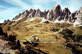
Major parks
|
|
|
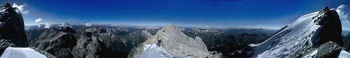
Panoramic view
See also
References
- ↑ Saussure le fils, M. de (1792): Analyse de la dolomie. Journal de Physique, vol. 40, pp. 161–173.
- ↑ Borgatti, Lisa; Soldati, Mauro (2010-08-01). "Landslides as a geomorphological proxy for climate change: A record from the Dolomites (northern Italy)". Geomorphology. Landslide geomorphology in a changing environment. 120 (1–2): 56–64. doi:10.1016/j.geomorph.2009.09.015.
- ↑ Huber, Alex. "The Perfect Perfume". Rock and Ice Magazine. Archived from the original on 2008-02-15.
Bibliography

- Provincia di Belluno, Provincia Autonoma di Bolzano-Alto Adige Autonome Provinz Bozen-Südtirol, Provincia di Pordenone, Provincia Autonoma di Trento, Provincia di Udine, Regione Autonoma Friuli Venezia Giulia, 2008. Nomination of the Dolomites for inscription on the World Natural Heritage List UNESCO. Nomination Document. 363 pp. https://web.archive.org/web/20131225070444/http://fondazionedolomitiunesco.org/documentazione-2/01_DOLOMITES_nomination_document_jan2008_1236608233_1294933181.pdf
- "HD Pictures of the main areas of the Dolomites". Bruno Mandolesi.
- "360 degree panorama Dolomites". SiMedia Srl. Retrieved 14 April 2010.
- Roger. "Walks and Via Ferrata in the Dolomites". CommunityWalk.com. Retrieved 14 April 2010.
- "Strada delle 52 Gallerie". Eclectica.
- "Monte Piana in the Dolomites". Eclectica. August 21, 2006.
- "Via Ferrata Lagazuoi Tunnels". Eclectica. August 9, 2006.
- "Up to the Turquoise Lake". Eclectica. August 1, 2006.
External links
| Wikimedia Commons has media related to Dolomites. |
- Franco Grisa Timelapse
- Italian official cartography (Istituto Geografico Militare - IGM); on-line version: www.pcn.minambiente.it
Mountain ranges of the Southern Limestone Alps according to the AVE | ||
|---|---|---|
