Monzambano
| Monzambano Mosambà (Emilian) | ||
|---|---|---|
| Comune | ||
| Comune di Monzambano | ||
 | ||
| ||
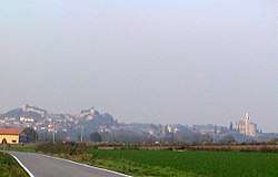
 Monzambano Location of Monzambano in Italy | ||
| Coordinates: 45°23′N 10°42′E / 45.383°N 10.700°ECoordinates: 45°23′N 10°42′E / 45.383°N 10.700°E | ||
| Country | Italy | |
| Region | Lombardy | |
| Province | Mantua (MN) | |
| Frazioni | Castellaro Lagusello, Pille, Olfino | |
| Government | ||
| • Mayor | Giorgio Cappa | |
| Area | ||
| • Total | 29.9 km2 (11.5 sq mi) | |
| Elevation | 88 m (289 ft) | |
| Population (28 February 2017)[1] | ||
| • Total | 4,835 | |
| • Density | 160/km2 (420/sq mi) | |
| Demonym(s) | Monzambanesi | |
| Time zone | UTC+1 (CET) | |
| • Summer (DST) | UTC+2 (CEST) | |
| Postal code | 46040 | |
| Dialing code | 0376 | |
| Patron saint | St. Bartholomew | |
| Website | Official website | |
Monzambano (Upper Mantovano: Mosambà) is a comune (municipality) in the Province of Mantua in the Italian region Lombardy, located about 120 kilometres (75 mi) east of Milan and about 25 kilometres (16 mi) northwest of Mantua.
World heritage site
It is home to one or more prehistoric pile-dwelling (or stilt house) settlements that are part of the Prehistoric Pile dwellings around the Alps UNESCO World Heritage Site.[2]
References
- ↑ All demographics and other statistics: Italian statistical institute Istat.
- ↑ UNESCO World Heritage Site - Prehistoric Pile dwellings around the Alps
External links

This article is issued from
Wikipedia.
The text is licensed under Creative Commons - Attribution - Sharealike.
Additional terms may apply for the media files.