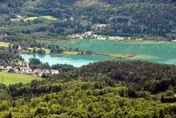
Keutschacher See
| Keutschacher See Lake Keutschach | |
|---|---|
 Eastern shore | |
| Location | Carinthia |
| Coordinates | 46°35′10″N 14°9′40″E / 46.58611°N 14.16111°ECoordinates: 46°35′10″N 14°9′40″E / 46.58611°N 14.16111°E |
| Type | glacial lake |
| Primary inflows | Rakouzabach, Weißenbach |
| Primary outflows | Reifnitzbach to Wörthersee |
| Catchment area | 29.81 km2 (11.51 sq mi) |
| Basin countries | Austria |
| Max. length | 2 km (1.2 mi) |
| Max. width | 1.1 km (0.68 mi) |
| Surface area | 1.327 km2 (0.512 sq mi) |
| Average depth | 10.3 m (34 ft) |
| Max. depth | 15.6 m (51 ft) |
| Water volume | 13,600,000 m3 (11,000 acre⋅ft) |
| Residence time | 0.75 years |
| Surface elevation | 506 m (1,660 ft) |
| Settlements | Keutschach am See |
| UNESCO World Heritage site | |
| Part of | Prehistoric Pile Dwellings around the Alps |
| Criteria | Cultural: (iv), (v) |
| Reference | 1363-057 |
| Inscription | 2011 (35th Session) |
| Area | 0.21 ha (0.52 acres) |
| Buffer zone | 132.5 ha (327 acres) |
References
External links
![]()
| Main lakes | 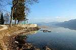 | |
|---|---|---|
| Secondary lakes |
| |
This article is issued from
Wikipedia.
The text is licensed under Creative Commons - Attribution - Sharealike.
Additional terms may apply for the media files.