Aqueduct of Vanvitelli
| UNESCO World Heritage site | |
|---|---|
 The Aqueduct of Vanvitelli | |
| Location | Benevento Province, Province of Caserta, Italy |
| Part of | 18th-Century Royal Palace at Caserta with the Park, the Aqueduct of Vanvitelli, and the San Leucio Complex |
| Criteria | Cultural: (i), (ii), (iii), (iv) |
| Reference | 549rev |
| Inscription | 1997 (21st Session) |
| Area | 87.37 ha (0.3373 sq mi) |
| Buffer zone | 110.76 ha (0.4276 sq mi) |
| Coordinates | 41°03′33″N 14°24′06″E / 41.05917°N 14.40167°ECoordinates: 41°03′33″N 14°24′06″E / 41.05917°N 14.40167°E |
 Location of Aqueduct of Vanvitelli in Italy | |
The Aqueduct of Vanvitelli or Caroline Aqueduct is an aqueduct built to supply the Reggia di Caserta and the San Leucio complex, supplied by water arising at the foot of Taburno, from the springs of the Fizzo, in the territory of Bucciano (BN), which it carries along a winding 38 km route (mostly underground).
Commissioned by Charles of Bourbon and designed by Luigi Vanvitelli (after whom it derives its two names), its construction began in March 1753 and concluded with its opening on 7 May 1762.
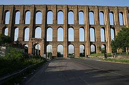
Of particular architectural value is the perfectly preserved 529-metre-long (1,736 ft) section in tufa bridging the Valle di Maddaloni between Monte Longano (to the east) and Monte Garzano (to the west) - this section was made a World Heritage Site in 1997 and (modelled on ancient Roman aqueducts) is made of three rows of arches, 55.8 metres (183 ft) high at its highest point.
