Wolpertswende
| Wolpertswende | ||
|---|---|---|
| ||
 Wolpertswende Location of Wolpertswende within Ravensburg district 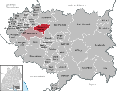  | ||
| Coordinates: 47°53′40″N 09°36′45″E / 47.89444°N 9.61250°ECoordinates: 47°53′40″N 09°36′45″E / 47.89444°N 9.61250°E | ||
| Country | Germany | |
| State | Baden-Württemberg | |
| Admin. region | Tübingen | |
| District | Ravensburg | |
| Municipal assoc. | Fronreute-Wolpertswende | |
| Government | ||
| • Mayor | Eberhard Heurich | |
| Area | ||
| • Total | 26.35 km2 (10.17 sq mi) | |
| Elevation | 569 m (1,867 ft) | |
| Population (2017-12-31)[1] | ||
| • Total | 4,149 | |
| • Density | 160/km2 (410/sq mi) | |
| Time zone | CET/CEST (UTC+1/+2) | |
| Postal codes | 88284 | |
| Dialling codes | 07502 | |
| Vehicle registration | RV | |
| Website | www.wolpertswende.de | |

Wolpertswende is a town in the district of Ravensburg in Baden-Württemberg in Germany.
World heritage site
It is home to one or more prehistoric pile-dwelling (or stilt house) settlements that are part of the Prehistoric Pile dwellings around the Alps UNESCO World Heritage Site.[2]
References
- ↑ "Bevölkerung nach Nationalität und Geschlecht am 31. Dezember 2017". Statistisches Landesamt Baden-Württemberg (in German). 2018.
- ↑ UNESCO World Heritage Site - Prehistoric Pile dwellings around the Alps
This article is issued from
Wikipedia.
The text is licensed under Creative Commons - Attribution - Sharealike.
Additional terms may apply for the media files.