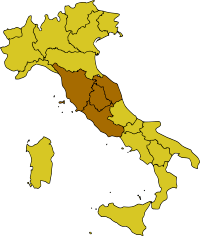
Central Italy
 | |
| Regional statistics | |
|---|---|
| Composition | |
| Area - Total |
58,052 km2 (22,414 sq mi) |
| Population - Total |
12,067,524[1] (2016 est.) |
| GDP | €343.7 billion (2008)[2] |
Central Italy (Italian: Italia centrale or just Centro) is one of the five official statistical regions of Italy used by the National Institute of Statistics (ISTAT), a first level NUTS region and a European Parliament constituency.
Regions
Central Italy encompasses four of the country's 20 regions:
The southernmost and easternmost parts of Lazio (Sora, Cassino, Gaeta, Cittaducale, Formia, and Amatrice districts) are often included in Southern Italy (Mezzogiorno) for cultural and historical reasons, since they were once part of the Kingdom of the Two Sicilies and southern Italian dialects are spoken.
As a geographical region, however, Central Italy may also sometimes include the regions of Abruzzo and Molise,[3][4][5] which are usually part of Southern Italy for cultural and historical reasons.
Politics
Marche, Tuscany and Umbria form, along with Emilia-Romagna to the immediate north, what is traditionally the most left-wing region in Italy.
Lazio, particularly outside of Rome, is more politically conservative, a trait which it shares with Southern Italy.
See also
References
- ↑ "Statistiche demografiche ISTAT". www.demo.istat.it.
- ↑ "Eurostat - Tables, Graphs and Maps Interface (TGM) table". epp.eurostat.ec.europa.eu.
- ↑ Source: Touring Club Italiano (TCI), "Atlante stradale d'Italia". 1999–2000 TCI Atlas. ISBN 88-365-1115-5 (Northern Italy volume) – ISBN 88-365-1116-3 (Central Italy volume) – ISBN 88-365-1117-1 (Southern Italy volume)
- ↑ Source: De Agostini, "Atlante Geografico Metodico". ISBN 88-415-6753-8
- ↑ Source: Enciclopedia Italiana "Treccani"
| History |
|  | ||||
|---|---|---|---|---|---|---|
| Geography | ||||||
| Politics | ||||||
| Economy | ||||||
| Society |
| |||||