Berlin Modernism Housing Estates
| UNESCO World Heritage site | |
|---|---|
| Location | Berlin, Germany |
| Criteria | Cultural: (ii), (iv) |
| Reference | 1239 |
| Inscription | 2008 (32nd Session) |
| Area | 88.1 ha (218 acres) |
| Buffer zone | 258.5 ha (639 acres) |
| Coordinates | 52°26′54″N 13°27′0″E / 52.44833°N 13.45000°ECoordinates: 52°26′54″N 13°27′0″E / 52.44833°N 13.45000°E |
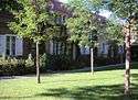
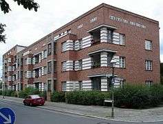
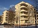
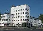
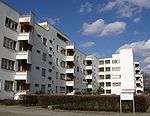
Berlin Modernism Housing Estates (German: Siedlungen der Berliner Moderne) are an ensemble of six subsidized housing estates from the early 20th century, listed as a UNESCO World Heritage Site. Dating mainly from the years of the Weimar Republic (1919–1933), when the city of Berlin was particularly progressive socially, politically and culturally, they are outstanding examples of the building reform movement that contributed to improving housing and living conditions for people with low incomes through the novel approaches to architecture and urban planning.[1] The estates also provide exceptional examples of new urban and architectural typologies, featuring fresh design solutions, as well as technical and aesthetic innovations.[1]
Bruno Taut, Martin Wagner and Walter Gropius were among the leading architects of these projects which exercised considerable influence on the development of housing around the world.[1]
List of Housing Estates

See also
- New Frankfurt, Frankfurt 1925-32
- Weissenhof Estate, Stuttgart 1927
Notes
- 1 2 3 "Berlin Modernism Housing Estates". UNESCO World Heritage Centre. Retrieved 4 July 2016.