Saint-Alban-de-Montbel
| Saint-Alban-de-Montbel | |
|---|---|
| Commune | |
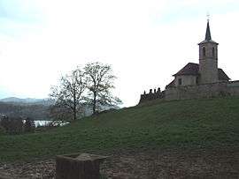 View of the church of Saint-Alban-de-Montbel next to the Lac d'Aiguebelette | |
 Saint-Alban-de-Montbel Location within Auvergne-Rhône-Alpes region  Saint-Alban-de-Montbel | |
| Coordinates: 45°33′09″N 5°47′03″E / 45.5525°N 5.7842°ECoordinates: 45°33′09″N 5°47′03″E / 45.5525°N 5.7842°E | |
| Country | France |
| Region | Auvergne-Rhône-Alpes |
| Department | Savoie |
| Arrondissement | Chambéry |
| Canton | Le Pont-de-Beauvoisin |
| Intercommunality | Lac d'Aiguebelette |
| Government | |
| • Mayor (2014–2020) | Annick Chevalier |
| Area1 | 4.55 km2 (1.76 sq mi) |
| Population (2014)2 | 629 |
| • Density | 140/km2 (360/sq mi) |
| Time zone | UTC+1 (CET) |
| • Summer (DST) | UTC+2 (CEST) |
| INSEE/Postal code | 73219 /73610 |
| Elevation | 372–528 m (1,220–1,732 ft) |
| Website | www.stalbandemontbel.fr |
|
1 French Land Register data, which excludes lakes, ponds, glaciers > 1 km2 (0.386 sq mi or 247 acres) and river estuaries. 2 Population without double counting: residents of multiple communes (e.g., students and military personnel) only counted once. | |
Saint-Alban-de-Montbel is a commune in the Savoie department in the Auvergne-Rhône-Alpes region in south-eastern France.
World heritage site
It is home to one or more prehistoric pile-dwelling (or stilt house) settlements that are part of the Prehistoric Pile dwellings around the Alps UNESCO World Heritage Site.[1]
See also
References
| Wikimedia Commons has media related to Saint-Alban-de-Montbel. |
External links
This article is issued from
Wikipedia.
The text is licensed under Creative Commons - Attribution - Sharealike.
Additional terms may apply for the media files.