Fiavé
| Fiavé | |
|---|---|
| Comune | |
| Comune di Fiavé | |
 Fiavé Location of Fiavé in Italy | |
| Coordinates: 46°0′16″N 10°50′32″E / 46.00444°N 10.84222°ECoordinates: 46°0′16″N 10°50′32″E / 46.00444°N 10.84222°E | |
| Country | Italy |
| Region | Trentino-Alto Adige/Südtirol |
| Province | Trentino (TN) |
| Frazioni | Ballino, Favrio, Stumiaga |
| Area | |
| • Total | 24.3 km2 (9.4 sq mi) |
| Elevation | 669 m (2,195 ft) |
| Population (Dec. 2004) | |
| • Total | 1,053 |
| • Density | 43/km2 (110/sq mi) |
| Time zone | UTC+1 (CET) |
| • Summer (DST) | UTC+2 (CEST) |
| Postal code | 38075 |
| Dialing code | 0465 |
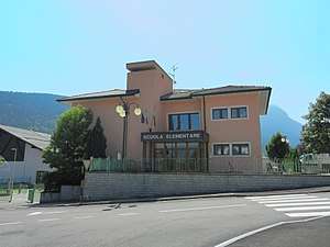
The elementary school of Fiavè
Fiavé is a comune (municipality) in Trentino in the northern Italian region Trentino-Alto Adige/Südtirol, located about 25 kilometres (16 mi) southwest of Trento. As of 31 December 2004, it had a population of 1,053 and an area of 24.3 square kilometres (9.4 sq mi).[1]
The municipality of Fiavè contains the frazioni (subdivisions, mainly villages and hamlets) Ballino, Favrio and Stumiaga.
Fiavè borders the following municipalities: Comano Terme, Bleggio Superiore, Ledro and Tenno.
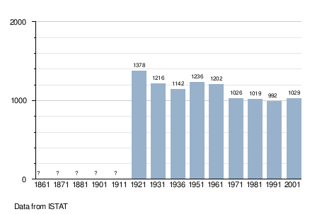
Demographic evolution
World heritage site
It is home to one or more prehistoric pile-dwelling (or stilt house) settlements that are part of the Prehistoric Pile dwellings around the Alps UNESCO World Heritage Site.[2]
References
- ↑ All demographics and other statistics: Italian statistical institute Istat.
- ↑ UNESCO World Heritage Site - Prehistoric Pile dwellings around the Alps

This article is issued from
Wikipedia.
The text is licensed under Creative Commons - Attribution - Sharealike.
Additional terms may apply for the media files.