Penguin Island (South Shetland Islands)
 King George Island | |
 Penguin Island Location of Penguin Island  Penguin Island Penguin Island (Antarctica) | |
| Geography | |
|---|---|
| Location | Antarctica |
| Coordinates | 62°06′00″S 57°55′41″W / 62.10000°S 57.92806°WCoordinates: 62°06′00″S 57°55′41″W / 62.10000°S 57.92806°W |
| Length | 1.7 km (1.06 mi) |
| Width | 1.4 km (0.87 mi) |
| Highest elevation | 180 m (590 ft) |
| Highest point | Deacon Peak |
| Administration | |
| Administered under the Antarctic Treaty System | |
| Demographics | |
| Population | Uninhabited |
| Penguin Island | |
|---|---|
| Highest point | |
| Elevation | 180 m (590 ft) |
| Coordinates | 62°06′S 57°56′W / 62.10°S 57.93°W |
| Geography | |
| Location | Antarctica |
| Topo map | USGS |
| Geology | |
| Mountain type | Stratovolcano |
| Last eruption | 1905 (?) |
Penguin Island (also known as Georges Island, Île Pingouin, Isla Pingüino, and Penguin Isle) is one of the smaller of the South Shetland Islands of Antarctica.
History
Penguin Island was sighted in January 1820 by a British expedition under Edward Bransfield, and so named by him because penguins occupied the shores of the island.[1]
Description
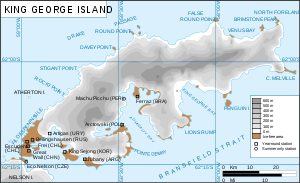
The island, which is ice-free and oval shaped, 1.4 km (0.87 mi) wide by 1.7 km (1.1 mi) long, lies close off the south coast of the much larger King George Island, and marks the eastern side of the entrance to King George Bay. It has a shoreline of low cliffs, with a beach on the north coast providing access. There is a small lake in the north-east.[2] It is capped by Deacon Peak, a basaltic scoria cone. Deacon Peak was last thought to be active about 300 years ago. Petrel Crater, a maar crater, is located on the east side of the island, and is thought to have last erupted in or around 1905.[3]
Important Bird Area
The island has been identified as an Important Bird Area (IBA) by BirdLife International because it supports a wide range of seabirds including a breeding colony of over 600 pairs of southern giant petrels. Other birds nesting at the site include Adélie and chinstrap penguins, Antarctic terns and kelp gulls. Weddell and southern elephant seals regularly haul out.[2]
See also
References
- ↑ "Penguin Island". Global Volcanism Program. Smithsonian Institution. Retrieved 2009-02-28.
- 1 2 "Penguin Island, King George Island". BirdLife data zone: Important Bird Areas. BirdLife International. 2013. Retrieved 2013-01-13.
- ↑ LeMasurier, W. E.; Thomson, J. W., eds. (1990). Volcanoes of the Antarctic Plate and Southern Oceans. American Geophysical Union. p. 512 pp. ISBN 0-87590-172-7. |Club Penguin
![]()
External links
- Composite Antarctic Gazetteer.
- |Information on the South Shetland Islands including Penguin Island.
| General |
| .svg.png) |
|---|---|---|
| Geographic regions | ||
| Waterways | ||
| Famous explorers | ||