Murray Island (Antarctica)
 Location of Pefaur (Ventimiglia) Peninsula on Danco Coast, Antarctic Peninsula | |
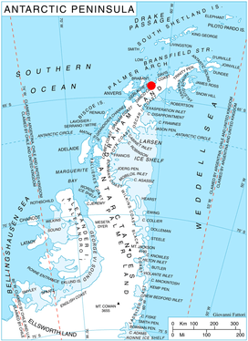
 Murray Islands Location in Antarctica | |
| Geography | |
|---|---|
| Location | Antarctica |
| Coordinates | 64°22′S 61°34′W / 64.367°S 61.567°WCoordinates: 64°22′S 61°34′W / 64.367°S 61.567°W |
| Administration | |
| Administered under the Antarctic Treaty System | |
| Demographics | |
| Population | Uninhabited |
Murray Island, also sometimes known as Bluff Island, is an island 6 km long lying at the south-west side of Hughes Bay, off the west coast of Graham Land, Antarctica. The feature has been known to sealers operating in the area since the 1820s, although it was shown on charts as part of the mainland. In 1922 the whale catcher Graham passed through the channel separating it from the mainland, proving its insularity. It was named in association with Cape Murray, the seaward extremity of the island.
Important Bird Area
A 98 ha ice-free site on the western side of a small peninsula on the northern coast of the island has been identified as an Important Bird Area (IBA) by BirdLife International because it supports a breeding colony of about 180 pairs of imperial shags.[1]
See also
Map
- British Antarctic Territory. Scale 1:200000 topographic map. DOS 610 Series, Sheet W 64 60. Directorate of Overseas Surveys, Tolworth, UK, 1978.
References
- ↑ "Bluff Island". BirdLife data zone: Important Bird Areas. BirdLife International. 2012. Retrieved 2012-12-09.
![]()