English Strait
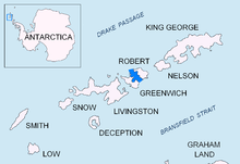
English Strait is the 10.5-mile (17-km) long and 1.2-mile (2-km) wide strait lying between Greenwich Island and Robert Island in the South Shetland Islands, Antarctica. Trending southeast-northwest, and entered between Santa Cruz Point and Edwards Point in the south, and Fort William Point and Okol Rocks, Aitcho Islands in the north. The name dates back to 1822 and is established in international usage.
Location
English Strait is located at 62°26′00″S 59°38′00″W / 62.43333°S 59.63333°W. British mapping in 1821, 1822 and 1968, Chilean in 1971, Argentine in 1980, and Bulgarian in 2009.
Map

L.L. Ivanov. Antarctica: Livingston Island and Greenwich, Robert, Snow and Smith Islands. Scale 1:120000 topographic map. Troyan: Manfred Wörner Foundation, 2010. ISBN 978-954-92032-9-5 (First edition 2009. ISBN 978-954-92032-6-4)
References
| General |
| .svg.png) |
|---|---|---|
| Geographic regions | ||
| Waterways | ||
| Famous explorers | ||