McFarlane Strait
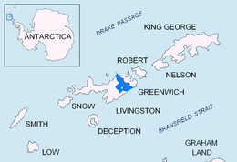


McFarlane Strait is a strait lying between Greenwich Island and Livingston Island, in the South Shetland Islands off Antarctica. It is 24 kilometres (13 nmi) long and 3 kilometres (1.6 nmi) wide. The name appears on an 1822 chart by Captain George Powell, a British sealer, and is now well established in international usage.[1]
Location
The strait is centred at (62°32′S 59°55′W / 62.533°S 59.917°WCoordinates: 62°32′S 59°55′W / 62.533°S 59.917°W), and entered between Williams Point and Duff Point to the northwest and between Renier Point and Ephraim Bluff to the southeast[2] (British mapping in 1822 and 1968, Chilean mapping in 1971, Argentine mapping in 1980, Spanish mapping in 1991, and Bulgarian mapping in 2005 and 2009).
Maps
- Chart of South Shetland including Coronation Island, &c. from the exploration of the sloop Dove in the years 1821 and 1822 by George Powell Commander of the same. Scale ca. 1:200000. London: Laurie, 1822.
- South Shetland Islands. Scale 1:200000 topographic map. DOS 610 Sheet W 62 60. Tolworth, UK, 1968.
- South Shetland Islands. Scale 1:200000 topographic map. DOS 610 Sheet W 62 58. Tolworth, UK, 1968.
- Islas Livingston y Decepción. Mapa topográfico a escala 1:100000. Madrid: Servicio Geográfico del Ejército, 1991.
- L.L. Ivanov et al., Antarctica: Livingston Island and Greenwich Island, South Shetland Islands (from English Strait to Morton Strait, with illustrations and ice-cover distribution), 1:100000 scale topographic map, Antarctic Place-names Commission of Bulgaria, Sofia, 2005
- L.L. Ivanov. Antarctica: Livingston Island and Greenwich, Robert, Snow and Smith Islands. Scale 1:120000 topographic map. Troyan: Manfred Wörner Foundation, 2010. ISBN 978-954-92032-9-5 (First edition 2009. ISBN 978-954-92032-6-4)
- Antarctic Digital Database (ADD). Scale 1:250000 topographic map of Antarctica. Scientific Committee on Antarctic Research (SCAR). Since 1993, regularly updated.
- L.L. Ivanov. Antarctica: Livingston Island and Smith Island. Scale 1:100000 topographic map. Manfred Wörner Foundation, 2017. ISBN 978-619-90008-3-0
References
- ↑ "McFarlane Strait". Geographic Names Information System. United States Geological Survey. Retrieved 2013-09-06.
- ↑ McFarlane Strait. SCAR Composite Antarctic Gazetteer
![]()
| General |
| .svg.png) |
|---|---|---|
| Geographic regions | ||
| Waterways | ||
| Famous explorers | ||