Låvebrua Island
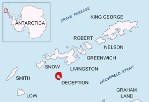 Location of Deception Island in the South Shetland Islands | |
 Låvebrua Island Location of Låvebrua Island  Låvebrua Island Låvebrua Island (Antarctica) | |
| Geography | |
|---|---|
| Location | Antarctica |
| Coordinates | 63°01′20″S 60°34′40″W / 63.02222°S 60.57778°WCoordinates: 63°01′20″S 60°34′40″W / 63.02222°S 60.57778°W |
| Highest elevation | 95 m (312 ft) |
| Administration | |
| Administered under the Antarctic Treaty System | |
| Demographics | |
| Population | Uninhabited |
Låvebrua Island is an island, 95 metres (310 ft) high, lying 1.3 kilometres (0.7 nmi) east of South Point, Deception Island, in the South Shetland Islands off Antarctica. It was charted by a British expedition under Henry Foster, 1828–31. The name was given by Norwegian whalers operating from Deception Island, and was in use as early as 1927; it is descriptive, meaning literally "threshing floor bridge" or "barn bridge", and was a slang word for the inclined plane of the whaling factories' slipway.[1][2]
See also
References
- ↑ "Låvebrua Island". Geographic Names Information System. United States Geological Survey. Retrieved 2013-06-05.
- ↑ Guren, Reidar (1935). Hvalfangsten i Sør-Ishavet [Whaling in the Southern Ocean] (in Norwegian). Oslo: J.W. Cappelens Forlag. p. 10.
|access-date=requires|url=(help)
![]()
| General |
| .svg.png) |
|---|---|---|
| Geographic regions | ||
| Waterways | ||
| Famous explorers | ||
This article is issued from
Wikipedia.
The text is licensed under Creative Commons - Attribution - Sharealike.
Additional terms may apply for the media files.