Petermann Island
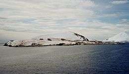 Petermann Island from a distance | |
 Petermann Island Location of Petermann Island  Petermann Island Petermann Island (Antarctica) | |
| Geography | |
|---|---|
| Location | Antarctica |
| Coordinates | 65°10′S 64°10′W / 65.167°S 64.167°W |
| Length | 2 km (1.2 mi) |
| Administration | |
| Administered under the Antarctic Treaty System | |
| Demographics | |
| Population | 0 |
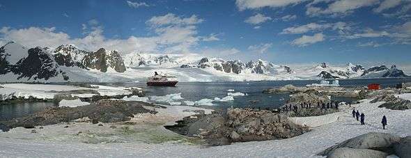
Petermann Island is a small, low and rounded island, lying off the northwest coast of Kiev Peninsula in Graham Land, Antarctica, a short distance south of Booth Island and the Lemaire Channel. It is a popular tourist destination.
Description
The island is 1.8 km (1.1 mi) long and 1.2 km (0.75 mi) across. It rises steeply to elevations of up to 250 m from a rocky coastline with raised pebble beaches. It has volcanic origins, with about half the land surface covered by a permanent, crevassed icecap. Ice-free areas have a sparse vegetation of mosses and lichens.[1]
History
The island was discovered by a German expedition of 1873-74, who named it after geographer August Petermann. The French Antarctic Expedition of 1908-10 wintered over aboard ship in a cove on the southeast side of the island, named Port Circumcision because it was spotted 1 January 1909, the traditional day for the Feast of the Circumcision.
Huts built by the expedition are gone, although a cairn remains, along with a refuge hut built by Argentina in 1955, and a cross commemorating three members of the British Antarctic Survey who died in a 1982 attempt to cross the sea ice from Faraday Station to Petermann.
Important Bird Area
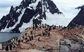
The island has been identified as an Important Bird Area (IBA) by BirdLife International because it supports a breeding colony of about 3000 pairs of gentoo penguins. Other birds nesting at the site in smaller numbers include Adélie penguins, imperial shags, Wilson's storm petrels and south polar skuas.[1]
See also
Groussac Refuge
| Groussac Refuge | |
|---|---|
| Refuge | |
.jpg) Naval refuge Groussac in 2013 | |
| Country |
|
| Location in Antarctic Peninsula |
Petermann Island Graham Land Antarctica |
| Administered by | Argentine Navy |
| Established | 1955 |
| Named for | Paul Groussac |
| Type | Seasonal |
| Status | Operational |
Groussac Refuge (65°10′33″S 64°08′10″W / 65.175727°S 64.136247°W) is an Argentine naval refuge (originally called Hippolyte Bouchard) in Antarctica, located on the southern coast of the Port Circumcision, on Petermann Island, next to the west coast of the Antarctic Peninsula. The refuge was inaugurated on February 6, 1955 and is operated by the Argentine Navy and was occupied periodically by personnel of the British Antarctic Survey of the former Faraday Station. The refuge take place in the middle of a colony of Gentoo penguin. Its current name is in honour of Paul Groussac, a French writer and historian who lived in Argentina, author of a plea on the Argentine claim of the Malvinas Islands and biographies of Argentine national heroes.[2]
References
- 1 2 "Petermann Island". BirdLife data zone: Important Bird Areas. BirdLife International. 2013. Retrieved 2013-01-14.
- ↑ "Refugio naval Groussac". Wikipedia Espanol. Wikimedia Foundation Inc. Retrieved September 22, 2018.
External links
| Wikimedia Commons has media related to Petermann Island. |